Report on Unzendake (Japan) — January 1991

Bulletin of the Global Volcanism Network, vol. 16, no. 1 (January 1991)
Managing Editor: Lindsay McClelland.
Unzendake (Japan) Ash eruption from new vent
Please cite this report as:
Global Volcanism Program, 1991. Report on Unzendake (Japan) (McClelland, L., ed.). Bulletin of the Global Volcanism Network, 16:1. Smithsonian Institution. https://doi.org/10.5479/si.GVP.BGVN199101-282100
Unzendake
Japan
32.761°N, 130.299°E; summit elev. 1483 m
All times are local (unless otherwise noted)
Unzen began to erupt on the morning of 12 February for the first time since 17 November . . . . No explosion sounds were heard, and no clear shocks were detected by seismometers. The first reported eruption plume was noted around 0700 on 12 February, but the exact time of the eruption's onset is not known. Steam containing ash rose continuously throughout the day, reaching a maximum height of 500 m. Slight ashfall was recognized downwind in inhabited areas, reaching 7 km SE from the vent.
The eruption occurred from a new 50-m-long NW-SE line of small vents (named Byobu-iwa) 500 m E of Fugen-dake peak and 170 m WSW of Jigoku-ato crater, one of two that erupted on 17 November. By 1030 on 12 February, ash and lapilli deposits were 30 cm thick at an uninhabited shrine 10 m E of the vent's rim. No incandescence was seen and no juvenile material was detected in the ash. The eruption was considered to be phreatic. Emission of steam containing ash continued at similar levels throughout 13 February and persisted through the morning of 14 February.
The steam plume from Tsukumo-jima crater, emitted since 17 November, steadily declined in height through January and early February. Weak steam emission, reaching 10 m height, began in the middle of January in Jigoku-ato crater, which had been quiet since December.
Seismicity. An earthquake swarm took place on 15 January after 2 months of relative quiet (figure 10). Three shocks were felt during the swarm at UWS . . . . Another swarm took place at night on 13 February, and five shocks were felt at the station. Earthquakes were at shallow depth about 5 km W of Fugen-dake peak in January and February, the same epicentral zone as in previous months.
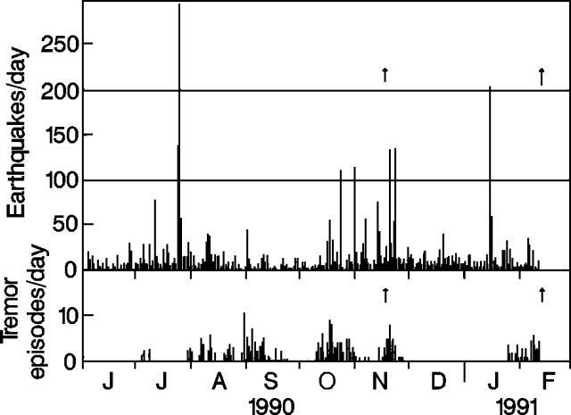 |
Figure 10. Daily number of recorded earthquakes (top) and tremor episodes (bottom) at Unzen, June 1990-early February 1991. Arrows mark small eruptions on 17 November and 12 February. Courtesy of JMA. |
Tremor began to be detected on 25 January . . . . Tremor characteristics were similar to July-November 1990; durations ranged from about 30 to 60 seconds and amplitudes were from 0 to 2 µm, a little larger than those of July-November (figure 11). Tremor occurrence was unchanged before and after the eruption.
 |
Figure 11. Amplitudes of tremor episodes at Unzen, June 1990-early February 1991. Arrows mark small eruptions on 17 November and 12 February. Courtesy of JMA. |
Geological Summary. The massive Unzendake volcanic complex comprises much of the Shimabara Peninsula east of the city of Nagasaki. An E-W graben, 30-40 km long, extends across the peninsula. Three large stratovolcanoes with complex structures, Kinugasa on the north, Fugen-dake at the east-center, and Kusenbu on the south, form topographic highs on the broad peninsula. Fugendake and Mayuyama volcanoes in the east-central portion of the andesitic-to-dacitic volcanic complex have been active during the Holocene. The Mayuyama lava dome complex, located along the eastern coast west of Shimabara City, formed about 4000 years ago and was the source of a devastating 1792 CE debris avalanche and tsunami. Historical eruptive activity has been restricted to the summit and flanks of Fugendake. The latest activity during 1990-95 formed a lava dome at the summit, accompanied by pyroclastic flows that caused fatalities and damaged populated areas near Shimabara City.
Information Contacts: JMA.