Report on Unzendake (Japan) — February 1991

Bulletin of the Global Volcanism Network, vol. 16, no. 2 (February 1991)
Managing Editor: Lindsay McClelland.
Unzendake (Japan) Ash emission declines; continued strong seismicity
Please cite this report as:
Global Volcanism Program, 1991. Report on Unzendake (Japan) (McClelland, L., ed.). Bulletin of the Global Volcanism Network, 16:2. Smithsonian Institution. https://doi.org/10.5479/si.GVP.BGVN199102-282100
Unzendake
Japan
32.761°N, 130.299°E; summit elev. 1483 m
All times are local (unless otherwise noted)
No incandescence has been seen and no juvenile material has been detected in ash from the eruption that began on 12 February. Ash was present in steam plumes until the end of February. Near the vent, ash was 2-3 m thick by the end of February. Slight ashfall extended about 10 km downwind in February but there have been no reports of ashfall in early March. Steam emission gradually declined through early March (figure 12). Tsukumo-jima and Jigoku-ato craters, active in the November eruption remained quiet.
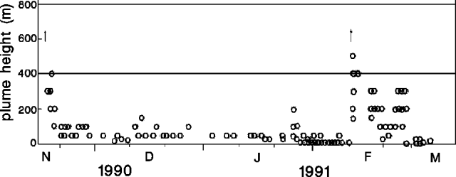 |
Figure 12. Height of steam cloud from Unzen, 17 November 1990-13 March 1991. Arrows mark eruptions on 17 November 1990 and 12 February 1991. Courtesy of JMA. |
Seismicity was at high levels and no changes were associated with the February eruption. Earthquake swarms were recorded on 13 and 27 February, and on 3 March (figure 13). Felt earthquakes appear in table 4. The 27 February swarm was the strongest since the initial swarm occurred on 25 July 1990. A seismometer near the summit recorded 937 earthquakes in February, up from 572 in January. Epicenters were concentrated 3-5 km W of the summit, unchanged from previous months. About five tremor episodes were recorded/day beginning 25 January. On 18 February, 22 episodes were recorded, the highest total since the first tremor episode in July 1990.
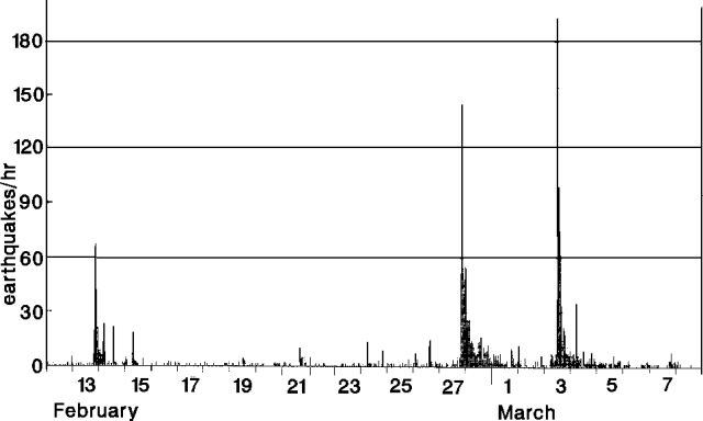 |
Figure 13. Hourly number of recorded earthquakes at Unzen, 12 February-8 March 1991. Courtesy of JMA. |
Table 4. Number of earthquakes felt at Unzendake Weather Station, 3.6 km SW of the summit, February-March 1991. Courtesy of JMA.
| Date | Felt Earthquakes |
| 05 Feb 1991 | 1 |
| 08 Feb 1991 | 1 |
| 13 Feb 1991 | 4 |
| 25 Feb 1991 | 1 |
| 26 Feb 1991 | 3 |
| 27 Feb 1991 | 28 |
| 28 Feb 1991 | 8 |
| 01 Mar 1991 | 2 |
| 03 Mar 1991 | 11 |
| 07 Mar 1991 | 1 |
| 10 Mar 1991 | 1 |
| 13 Mar 1991 | 1 |
| 17 Mar 1991 | 2 |
| 25 Mar 1991 | 1 |
| 28 Mar 1991 | 2 |
Geological Summary. The massive Unzendake volcanic complex comprises much of the Shimabara Peninsula east of the city of Nagasaki. An E-W graben, 30-40 km long, extends across the peninsula. Three large stratovolcanoes with complex structures, Kinugasa on the north, Fugen-dake at the east-center, and Kusenbu on the south, form topographic highs on the broad peninsula. Fugendake and Mayuyama volcanoes in the east-central portion of the andesitic-to-dacitic volcanic complex have been active during the Holocene. The Mayuyama lava dome complex, located along the eastern coast west of Shimabara City, formed about 4000 years ago and was the source of a devastating 1792 CE debris avalanche and tsunami. Historical eruptive activity has been restricted to the summit and flanks of Fugendake. The latest activity during 1990-95 formed a lava dome at the summit, accompanied by pyroclastic flows that caused fatalities and damaged populated areas near Shimabara City.
Information Contacts: JMA.