Report on Telica (Nicaragua) — February 1991

Bulletin of the Global Volcanism Network, vol. 16, no. 2 (February 1991)
Managing Editor: Lindsay McClelland.
Telica (Nicaragua) Large vapor clouds; fumaroles to 246°C
Please cite this report as:
Global Volcanism Program, 1991. Report on Telica (Nicaragua) (McClelland, L., ed.). Bulletin of the Global Volcanism Network, 16:2. Smithsonian Institution. https://doi.org/10.5479/si.GVP.BGVN199102-344040
Telica
Nicaragua
12.606°N, 86.84°W; summit elev. 1036 m
All times are local (unless otherwise noted)
"In February 1990, fumarolic activity had declined from 1989 levels, with no observed incandescence. On 29 May, large clouds were observed from León and El Limón mine (50 km away). Subsequent observations at the crater revealed a strong geyser-like steam vent in the 1984/1987 explosion pits (figures 3 and 4). The steam at the crater edge (200 m above the vent) was warm and highly toxic; respiration was impossible without a gas mask. Local inhabitants reported crop damage from acid rain up to 2 km from the crater.
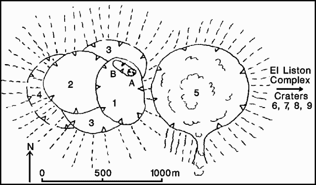 |
Figure 3. Sketch map of Telica showing the distribution of craters (numbered in order of increasing age), and the 1984 (A) and 1987 (B) explosion pits. Compiled from from aerial photos. Courtesy of Benjamin van Wyk de Vries. |
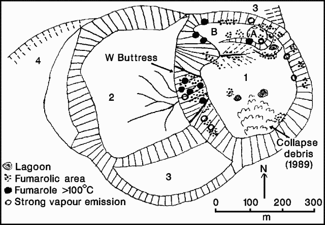 |
Figure 4. Sketch map of Telica's W craters, showing fumarole distribution 13 June 1990, drawn from on-site observation and aerial photographs. Courtesy of B. van Wyk de Vries. |
"Fumarole temperatures measured with an infrared radiometer on 13 June showed a maximum of 246°C in the SW side of the 1984/1987 explosion pits (figure 5). The steam vent was below 100°C. After heavy rain, the volume of steam increased enormously. The clear relationship between activity and precipitation was confirmed by local inhabitants, who claimed that such activity was common after storms, especially at the start of the wet season."
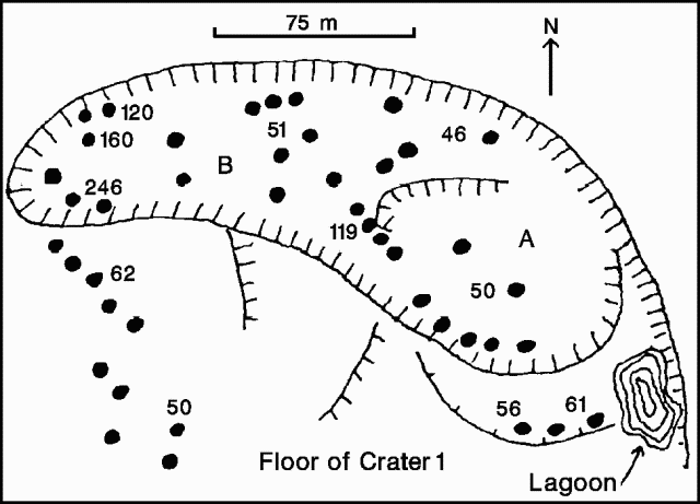 |
Figure 5. Sketch of Telica's 1984 / 87 explosion pits showing fumarole distribution and temperatures (in °C), 13 June 1990. All temperatures were measured using a Palmer "Colt" Radiometer with a 1° target field and 8-14 µm band, from 200-400 m distance. Courtesy of B. van Wyk de Vries. |
Geological Summary. Telica, one of Nicaragua's most active volcanoes, has erupted frequently since the beginning of the Spanish era. This volcano group consists of several interlocking cones and vents with a general NW alignment. Sixteenth-century eruptions were reported at symmetrical Santa Clara volcano at the SW end of the group. However, its eroded and breached crater has been covered by forests throughout historical time, and these eruptions may have originated from Telica, whose upper slopes in contrast are unvegetated. The steep-sided cone of Telica is truncated by a 700-m-wide double crater; the southern crater, the source of recent eruptions, is 120 m deep. El Liston, immediately E, has several nested craters. The fumaroles and boiling mudpots of Hervideros de San Jacinto, SE of Telica, form a prominent geothermal area frequented by tourists, and geothermal exploration has occurred nearby.
Information Contacts: B. van Wyk de Vries, O. Castellón, A. Murales, and V. Tenorio, INETER.