Report on Masaya (Nicaragua) — February 1991

Bulletin of the Global Volcanism Network, vol. 16, no. 2 (February 1991)
Managing Editor: Lindsay McClelland.
Masaya (Nicaragua) Rockfall activity declines after November 1989 collapse
Please cite this report as:
Global Volcanism Program, 1991. Report on Masaya (Nicaragua) (McClelland, L., ed.). Bulletin of the Global Volcanism Network, 16:2. Smithsonian Institution. https://doi.org/10.5479/si.GVP.BGVN199102-344100
Masaya
Nicaragua
11.9844°N, 86.1688°W; summit elev. 594 m
All times are local (unless otherwise noted)
"Growth of Santiago crater has slowed since the November 1989 collapse when 50,000 m3 of rock fell from the S (Plaza Sapper) side (figure 8). The overlook with protective wall and part of the parking lot were lost in this event. Cracks continue to open and widen on Plaza Sapper, but rockfalls decreased to negligible levels by April 1990. Seismic activity has been recorded at a station in the Masaya Volcano Museum, 5 km from the crater, and occasionally at a station in Nindirí crater, but overall, very little activity was detected. The tremor associated with the February 1989 lava lake and subsequent Strombolian activity (May-June 1989) was absent. Three samples of the 1989 ejecta were analysed at the Open Univ (UK); all are typical Masaya tholeiitic basalt, similar to that of 1965 and 1772. Fumarolic activity in Santiago is restricted to a few points surrounded by damp ground. Small areas of yellow sulfur deposits have built up locally. Vegetation has started to colonize the Nindirí and San Pedro craters, and some small grass patches have been established on the 1965 lava lake in Santiago.
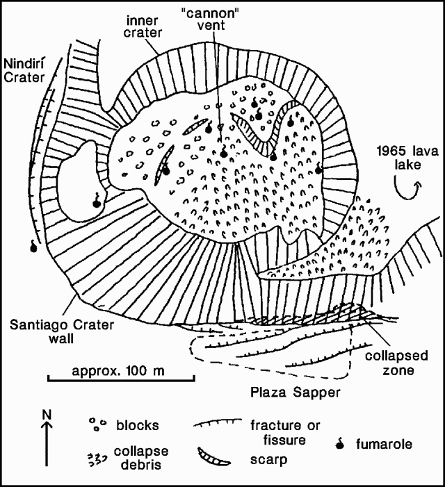 |
Figure 8. Sketch map of Santiago crater, Masaya, 19 December 1990. Courtesy of B. van Wyk de Vries. |
"A water well that was drilled 3 years ago, about 5 km N of the caldera (near the village of Veracruz) on the volcanic alignment extending from the volcano, was reported to have started to produce hot (almost boiling) water. Geologists from INETER are investigating the cause of this phenomenon. Two maar craters lie 1 km NE of the well."
Geological Summary. Masaya volcano in Nicaragua has erupted frequently since the time of the Spanish Conquistadors, when an active lava lake prompted attempts to extract the volcano's molten "gold" until it was found to be basalt rock upon cooling. It lies within the massive Pleistocene Las Sierras caldera and is itself a broad, 6 x 11 km basaltic caldera with steep-sided walls up to 300 m high. The caldera is filled on its NW end by more than a dozen vents that erupted along a circular, 4-km-diameter fracture system. The Nindirí and Masaya cones, the source of observed eruptions, were constructed at the southern end of the fracture system and contain multiple summit craters, including the currently active Santiago crater. A major basaltic Plinian tephra erupted from Masaya about 6,500 years ago. Recent lava flows cover much of the caldera floor and there is a lake at the far eastern end. A lava flow from the 1670 eruption overtopped the north caldera rim. Periods of long-term vigorous gas emission at roughly quarter-century intervals have caused health hazards and crop damage.
Information Contacts: B. van Wyk de Vries, O. Castellón, A. Murales, and V. Tenorio, INETER.