Report on Unzendake (Japan) — April 1991

Bulletin of the Global Volcanism Network, vol. 16, no. 4 (April 1991)
Managing Editor: Lindsay McClelland.
Unzendake (Japan) Ash emission from two vents; frequent seismicity; lava dome extruded into summit crater
Please cite this report as:
Global Volcanism Program, 1991. Report on Unzendake (Japan) (McClelland, L., ed.). Bulletin of the Global Volcanism Network, 16:4. Smithsonian Institution. https://doi.org/10.5479/si.GVP.BGVN199104-282100
Unzendake
Japan
32.761°N, 130.299°E; summit elev. 1483 m
All times are local (unless otherwise noted)
Frequent, almost continuous, ash emissions (500 m high) continued in April from two vents. In mid-April, the most intense activity switched from Byobu-iwa vent . . . to Jigoku-ato vent . . . . No earthquake swarms were recorded in April, but seismicity remained high. A total of 733 earthquakes was recorded and 27 felt . . . compared to 734 recorded and 21 felt in March. Most of the events were located a few kilometers W of Fugen-dake peak . . . . The number of tremor episodes increased in April (181, compared to 99 in March), as did amplitudes and durations (figure 16).
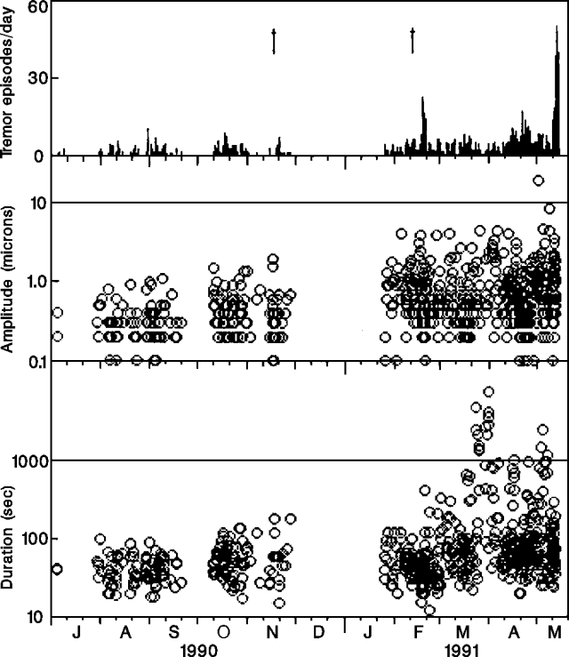 |
Figure 16. Daily number (top), amplitude (middle), and duration (bottom) of tremor episodes at Unzen, July 1990-early May 1991. Arrows at top mark eruptions on 17 November 1990 and 12 February 1991. Courtesy of JMA. |
A swarm of microearthquakes, the first since July 1990, began 13 May and continued as of 17 May. Ash emissions were at low levels during this period. Heavy rains on recently fallen tephra caused lahars in at least one flank valley. The press reported that more than 1,200 people were evacuated on 19 May. A lava dome was extruded into the summit crater before dawn on 21 May. Small ash emissions occurred from the dome and fissures exposed its interior.
Geological Summary. The massive Unzendake volcanic complex comprises much of the Shimabara Peninsula east of the city of Nagasaki. An E-W graben, 30-40 km long, extends across the peninsula. Three large stratovolcanoes with complex structures, Kinugasa on the north, Fugen-dake at the east-center, and Kusenbu on the south, form topographic highs on the broad peninsula. Fugendake and Mayuyama volcanoes in the east-central portion of the andesitic-to-dacitic volcanic complex have been active during the Holocene. The Mayuyama lava dome complex, located along the eastern coast west of Shimabara City, formed about 4000 years ago and was the source of a devastating 1792 CE debris avalanche and tsunami. Historical eruptive activity has been restricted to the summit and flanks of Fugendake. The latest activity during 1990-95 formed a lava dome at the summit, accompanied by pyroclastic flows that caused fatalities and damaged populated areas near Shimabara City.
Information Contacts: JMA; H. Glicken, Tokyo Metropolitan Univ; AP.