Report on Unzendake (Japan) — May 1991

Bulletin of the Global Volcanism Network, vol. 16, no. 5 (May 1991)
Managing Editor: Lindsay McClelland.
Unzendake (Japan) 41 killed by pyroclastic flow from lava dome
Please cite this report as:
Global Volcanism Program, 1991. Report on Unzendake (Japan) (McClelland, L., ed.). Bulletin of the Global Volcanism Network, 16:5. Smithsonian Institution. https://doi.org/10.5479/si.GVP.BGVN199105-282100
Unzendake
Japan
32.761°N, 130.299°E; summit elev. 1483 m
All times are local (unless otherwise noted)
On 3 June a large pyroclastic flow formed near the summit of Fugen-dake cone and moved down the E flank, reaching the outskirts of Kita-Kamikoba, 3 km from the 20 May lava dome. Forty people were killed, including volcanologists Harry Glicken, and Maurice and Katia Krafft. The pyroclastic flow and accompanying fires destroyed more than 56 houses and portions of Shimabara were blanketed with wet ash. A larger pyroclastic flow, on 8 June, destroyed an additional 73 houses in Shimabara and Fukae, but no injuries were reported. On 11 June, ejecta from an explosive event, not associated with pyroclastic-flow activity, damaged houses and car windows in Shimabara. Ashfall was reported 250 km to the NE. Dome extrusion and pyroclastic-flow activity at Unzen continued as of 24 June.
Premonitory activity and small ash emission. Increased seismicity was initially centered in Chijiiwa Bay, 13 km W, in November 1989, and gradually migrated E in July-October 1990, when seismicity increased further and the first volcanic tremor was recorded. Following several earthquake swarms, including one on 13-14 November (centered 5 km W of the summit at shallow depth), the volcano erupted on 17 November, weakly emitting ash to heights of 300-400 m from two newly formed vents (Jigoku-ato and Tsukumo-jima) within existing craters roughly 650 m E of the summit (figure 17). Ash emissions, tremor, and swarm activity quickly ceased, but steam emission continued and seismicity remained at high levels. An earthquake swarm occurred on 15 January and tremor resumed on 25 January (figure 18).
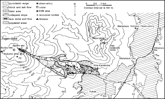 |
Figure 17. Map showing the distribution of the three facies of the 3 June pyroclastic flow at Unzen. Crosses represent locations of recovered bodies. Data from Kyushu and Kagoshima universities. Body locations from The Japan Times. Courtesy of JMA. |
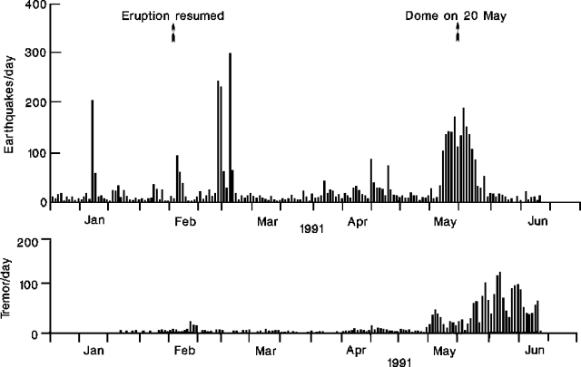 |
Figure 18. Daily number of earthquakes (top) and tremor episodes (bottom) at Unzen, January-18 June 1991. Arrows represent resumption of explosive activity on 12 February and dome appearance on 20 May 1991. Courtesy of JMA. |
Phreato-magmatic activity, February-May. A second eruption on 12 February produced 500-m ash plumes from a new 50-m-long line of small vents (named Byobu-iwa) 170 m WSW of Jigoku-ato crater and 500 m E of the summit. Deposits of ash and lapilli reached 30 cm thick (10 m E of the vent) but no incandescence was seen and no juvenile material was detected in the ash. Frequent small ash emissions continued from Byobu-iwa vent and seismicity remained at high levels.
In early April, ash emissions resumed at Jigoku-ato vent, which widened and began to eject bombs. By mid-April, Jigoku-ato was the site of the most intense activity. The Geographic Survey Institute detected a summit offset of 11 cm to the W on 12 April.
Juvenile volcanic glass was first recognized on 12 May, although emissions remained small. Shallow microseismicity beneath Jigoku-ato rose sharply the next day, and EDM measurements showed rapid inflation of the summit region.
Debris flows, 15 and 19 May. Heavy rains on accumulated ash deposits triggered debris flows along the Mizunashi River on 15 and 19 May that destroyed two bridges and caused the temporary evacuation of about 1,300 people from Shimabara.
Lava extrusion, 20-23 May. On 20 May, high-silica dacite (table 6) lava extrusion began in Jigoku-ato crater. By the following day large fractures had appeared and the dome had separated into four parts. Debris flows along the Mizunashi River continued; after the fourth debris flow, at 0252 on 21 May, about 1,100 people were evacuated. Water level in the river dropped following a debris flow at 0445, and people were allowed to return home at 0555.
Table 6. Chemical composition of eruptive products from Unzen. Sample 1 - block from 24 May 1991 pyroclastic flow. Sample 2 - surface of lava dome 1 June 1991. Sample 3 - pumice block from 8 June 1991 pyroclastic flow. Sample 4 - 1792 lava flow. Total Fe as Fe2O3. Analyses performed by XRF at Kyushu Univ, normalized anhydrous.
| Component | Sample 1 | Sample 2 | Sample 3 | Sample 4 |
| SiO2 | 65.92 | 66.03 | 66.18 | 66.1 |
| TiO2 | 0.66 | 0.64 | 0.65 | 0.65 |
| Al2O3 | 15.46 | 15.47 | 15.46 | 15.8 |
| Fe2O3* | 4.18 | 4.14 | 4.07 | 4.28 |
| MnO | 0.09 | 0.08 | 0.08 | 0.09 |
| MgO | 2.39 | 2.37 | 2.34 | 2.24 |
| CaO | 4.90 | 4.98 | 4.86 | 4.56 |
| Na2O | 3.85 | 3.77 | 3.80 | 3.78 |
| K2O | 2.39 | 2.35 | 2.41 | 2.39 |
| P2O5 | 0.16 | 0.17 | 0.16 | 0.13 |
| Total | 100.02 | 100.00 | 100.01 | 100.02 |
The dome continued to grow, reaching about 110 m diameter and 44 m height (a few tens of meters above the crater rim) on 23 May, when material began spalling from its margins down the steep outer slopes. Large blocks, to 5 m in diameter (60-70 m3 volume), were observed falling from the dome, and explosive events produced grayish clouds to 100 m height. The Geological Society of Japan reported that Fugen-dake cone had expanded 89 cm from 10 to 22 May (figure 19), and that the lava dome front was moving E at 70-80 cm/hour.
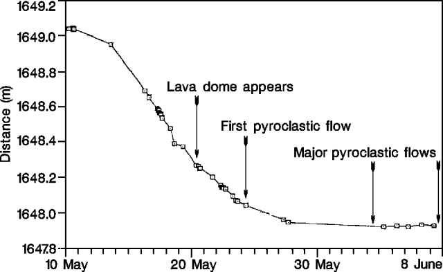 |
Figure 19. Results of EDM measurements between points T1 and F2 on the S flank of Fugen-dake cone at Unzen, 10 May-8 June. Shortening of this line reflects expansion of the cone as F2 moves toward T1. Data from the GSJ. Courtesy of JMA. |
Pyroclastic flows begin, 24 May. At 0810 on 24 May, a large explosion was heard as a portion of the lava dome collapsed, producing a pyroclastic flow that traveled about 1 km down the E flank to within 2 km of Kita-Kamikoba. The flow discolored trees and transported blocks 10 m in diameter. Smaller collapse/pyroclastic flow events occurred at 1755 and 1920.
About 1,300 people were evacuated on 24 May because of increasing mudflow hazard along the Mizunashi River, as volcanic debris accumulated and heavy rains continued. During the evening, workers dredged material from above a dam (2 km from the summit) constructed after the November 1990 eruption to reduce the mudflow danger. By 0600 the following morning the evacuation recommendation was withdrawn and residents were allowed to return home.
Heavy rain on 25 May made observation difficult, but dust and ash from a pyroclastic flow was seen at around 1145. The lava dome continued to grow at an estimated rate of 80,000 m3/day. Rain continued on 26 May, and ash plumes 600 m high were reported, but little is known about activity at the dome.
At 1130 on 26 May, a pyroclastic flow traveled into the Mizunashi valley, injuring a worker (2.6 km from the crater) who had climbed up from the dredging area for better views of the volcano. The flow traveled 3 km, to within 600 m of Kita-Kamikoba, and deposited ash 5 km E on Shimabara. Bursts of tremor accompanied this flow and the prior pyroclastic flow at 1113, suggesting that the tremor signal could be used to detect and count pyroclastic flows (figure 20).
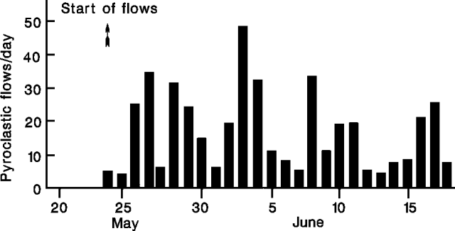 |
Figure 20. Daily number of pyroclastic flows determined seismically at Unzen, 20 May-18 June 1991. Number represents counts of tremor lasting >30 seconds with amplitudes larger than an empirical threshold. Courtesy of JMA. |
The 1130 pyroclastic flow, and the continued accumulation of debris in the river channel, prompted the evacuation of around 3,500 people from the surrounding valley. Several mudflows were reported during that evening, and rain soaked previously-deposited dust and ash to create more mud. Many people were allowed to return home the next day when the rain ceased.
Observations of the dome (27 May) revealed a v-shaped vent, from which a 60-m-wide tongue of lava was being extruded. Pyroclastic flows spawned from the margins of the lava tongue traveled along E and SE paths that joined at mid-flank. On 28 May, fluid (no longer blocky) lava overflowed the crater's E rim and moved down the outer flank, reaching about 700 m elevation by midnight.
The 26 May evacuation order was extended. Pyroclastic flows continued to form, reaching to within 500 m of Kita-Kamikoba on the 29th, and within 200 m on the 30th. Trees in the valley were burned to charcoal, suggesting that flow temperatures had increased. On 31 May, lava was observed emerging from the vent, and then avalanching 1 km down the steep slope in 30 seconds, producing a roaring sound that was heard 6 km E in Shimabara.
Pyroclastic flow kills 41, 3 June. At about 1610 on 3 June, an audible explosion and 6 minutes of recorded tremor signaled the collapse of a portion of the summit dome and lava flow. The resulting large pyroclastic flow moved down the Mizunashi River at reported speeds of up to 100 km/hour and entered Kita-Kamikoba. The core of the pyroclastic flow traveled about 3.2 km (figure 17) over a vertical drop of 1,000 m. An ash cloud surge apparently detached from the flow and traveled an additional 0.8 km, knocking down trees, burning houses, and leaving deposits up to 30 cm thick. Blasted zones occurred in places along the margins of the flow and surge. The volume of the deposits was estimated to be 7.3 x 10⁵ m3.
All of the casualties were within an evacuated "forbidden" zone and all were caused by the detached surge. The victims consisted of: 15 members of the Japanese press, three volcanologists, four taxi drivers, a few local residents, and members of police and fire brigades. Of the 41 people listed dead, 27 bodies were recovered, four remain missing and are presumed dead, and 10 died in hospitals from burns.
Pyroclastic flows continued over the next several days, hampering rescue and recovery efforts, but were less frequent. Lava effusion occurred at a constant rate of around 105 m3/day, producing a tongue 70-80 m wide and 100 m long by 5 June. Periodic explosions produced gas/ash columns 100 m high. One helicopter was grounded due to ash-related engine problems on 6 June. On 7 June, the evacuated zone was widened to include an additional 1,500 people, bringing the total number of evacuees to more than 7,200, and a fine of $75 was imposed on people entering the evacuated area. Observers reported that despite continued growth of the dome it had not yet recovered half of its pre-3 June size.
Large pyroclastic flow, 8 June. An increase in pyroclastic flow activity occurred in the afternoon of 8 June, with numerous small flows over a 5-hour period leading to a larger flow at 1723. The evacuation zone was again widened, to include parts of Fukae, bringing the total number evacuated to about 8,500. Multiple pyroclastic flows began at 1930. Finally, from 1951 to 2016, a continuous series of pyroclastic flows traveled 5.5 km down the Mizunashi River, through parts of Shimabara and Fukae, to within 50 m of Highway 57 (2 km from the sea). Deposits reached 100 m wide and had an estimated volume of ~1.0 x 10⁶ m3. The flows destroyed 73 houses, but no injuries were reported.
Activity continued, with an explosion (detected by infrared camera) at 2007 and a small pyroclastic flow at 2120. Ashfall from the explosion was deposited 90 km NE (in Hida) and 80 km N (in Fukuoka). Clasts 5 cm in diameter fell to 5 km.
Evacuation zones were expanded on 9 June and again on 10 June, to a total of 9,800 people. Mudflow hazards were considered high given the more than 1 x 10⁶ m3 of debris that completely filled the Mizunashi River channel and covered the surrounding valley.
Large explosive event, 11 June. By 11 June, a 50-m-wide dome partly filled the large horseshoe-shaped depression that formed 8 June on the E side of the summit dome. A large explosive ash emission, not associated with pyroclastic-flow formation, occurred at 2359-0003, accompanied by strong tremor and sharp deflation (10 µrad; figure 21). Houses, car windows, and two helicopters were damaged by tephra clasts (d = 1.0-2.0 g/cm3) >=15 cm in diameter that fell to 3.5 km (figure 22). Ash was deposited to 130 km NE (Oita) and 250 km NE (Matsuyama, Shikoku Is.). Two hours after the explosion, 25 µrad of inflation was recorded over a 10-hour period, suggesting rising magma.
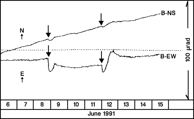 |
Figure 21. Change of ground tilt 850 m W of Unzen's dome, 6-15 June, 1991. Arrows represent large eruptive events on 8 and 11 June. E up corresponds to inflation of the summit area. Data from the Joint Monitoring Group of National Universities. Courtesy of JMA. |
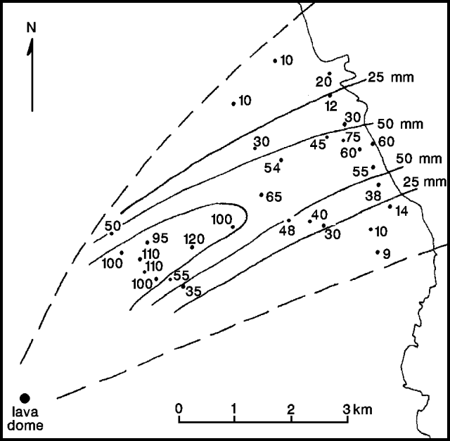 |
Figure 22. Isopleth map of maximum pumice clast sizes from the explosion at Unzen on 11 June at 2359. Data from Kyushu and Kagoshima universities. Courtesy of JMA. |
Continued activity. Dome extrusion and pyroclastic-flow formation continued at Unzen as of 24 June. On 14 June, the dome was 100 m wide and 50 m high; it grew another 20 m in height by 16 June. Cracks in the dome emitted gas to 200-300 m height, and periodic explosions produced 1-km-high ash columns. The evacuation area was again expanded on 17 June, bringing the total number of evacuees to more than 10,000.
Actions by Coordinating Committee. The following is from Daisuke Shimozuru, Chairman of the Coordinating Committee for the Prediction of Volcanic Eruptions. "The Japan Meteorological Agency (JMA) dispatched an observation team in mid-October to intensify seismic observation, assisting JMA's local observatory. Early in November, volcanic tremors were observed. We were very worried about an impending eruption, and asked the Ministry for financial aid for observations by university scientists. On 9 November, the Ministry decided to provide financial aid for observations by 6 universities. The university team set up seismic and deformation nets, in cooperation with Shimabara Volcano Observatory of Kyushu Univ." A chronology of Unzen's activity and statements and warnings issued by the Coordinating Committee is shown in table 7 (see following report).
Geological Summary. The massive Unzendake volcanic complex comprises much of the Shimabara Peninsula east of the city of Nagasaki. An E-W graben, 30-40 km long, extends across the peninsula. Three large stratovolcanoes with complex structures, Kinugasa on the north, Fugen-dake at the east-center, and Kusenbu on the south, form topographic highs on the broad peninsula. Fugendake and Mayuyama volcanoes in the east-central portion of the andesitic-to-dacitic volcanic complex have been active during the Holocene. The Mayuyama lava dome complex, located along the eastern coast west of Shimabara City, formed about 4000 years ago and was the source of a devastating 1792 CE debris avalanche and tsunami. Historical eruptive activity has been restricted to the summit and flanks of Fugendake. The latest activity during 1990-95 formed a lava dome at the summit, accompanied by pyroclastic flows that caused fatalities and damaged populated areas near Shimabara City.
Information Contacts: JMA; D. Shimozuru, Tokyo Univ of Agriculture; H. Kamata, GSJ; Public Works Research Institute, Ministry of Construction; K. Uto, USGS; M. Takahashi, SI; Kyodo News Service; The Japan Times; Asahi Shinbun; Yomiuri Shinbun; AP; UPI; Reuters.