Report on Ontakesan (Japan) — May 1991
Bulletin of the Global Volcanism Network, vol. 16, no. 5 (May 1991)
Managing Editor: Lindsay McClelland.
Ontakesan (Japan) Earthquake swarms and tremor; renewed steam emission from 1979 vent
Please cite this report as:
Global Volcanism Program, 1991. Report on Ontakesan (Japan) (McClelland, L., ed.). Bulletin of the Global Volcanism Network, 16:5. Smithsonian Institution. https://doi.org/10.5479/si.GVP.BGVN199105-283040
Ontakesan
Japan
35.893°N, 137.48°E; summit elev. 3067 m
All times are local (unless otherwise noted)
Many earthquakes and tremor episodes have been detected by a seismometer near the volcano since April, bringing seismicity to its highest levels since the start of regular seismic monitoring in 1988. Earthquake swarms were recorded on 20, 23, and 27 April, and 12 and 13 May, with tremor on 27 and 28 April, and 2 and 12-16 May (figure 8). In mid-May, steam began to emerge from a vent formed in the last eruption (in 1979) that had remained quiet since soon after the eruption ended. Similar seismicity continued in June, and as of the 19th, 170 earthquakes and eight tremor episodes had been recorded.
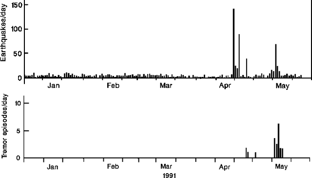 |
Figure 8. Daily number of earthquakes (top) and tremor episodes (bottom) at On-take, January-May, 1991. |
Geological Summary. The massive Ontakesan stratovolcano, the second highest volcano in Japan, lies at the southern end of the Northern Japan Alps. Ascending this volcano is one of the major objects of religious pilgrimage in central Japan. It is constructed within a largely buried 4 x 5 km caldera and occupies the southern end of the Norikura volcanic zone, which extends northward to Yakedake volcano. The older volcanic complex consisted of at least four major stratovolcanoes constructed from about 680,000 to about 420,000 years ago, after which Ontakesan was inactive for more than 300,000 years. The broad, elongated summit of the younger edifice is cut by a series of small explosion craters along a NNE-trending line. Several phreatic eruptions post-date the roughly 7300-year-old Akahoya tephra from Kikai caldera. The first historical eruption took place in 1979 from fissures near the summit. A non-eruptive landslide in 1984 produced a debris avalanche and lahar that swept down valleys south and east of the volcano. Very minor phreatic activity caused a dusting of ash near the summit in 1991 and 2007. A significant phreatic explosion in September 2014, when a large number of hikers were at or near the summit, resulted in many fatalities.
Information Contacts: JMA.