Report on Rincon de la Vieja (Costa Rica) — May 1991
Bulletin of the Global Volcanism Network, vol. 16, no. 5 (May 1991)
Managing Editor: Lindsay McClelland.
Rincon de la Vieja (Costa Rica) More details on 8 May eruption and deposits
Please cite this report as:
Global Volcanism Program, 1991. Report on Rincon de la Vieja (Costa Rica) (McClelland, L., ed.). Bulletin of the Global Volcanism Network, 16:5. Smithsonian Institution. https://doi.org/10.5479/si.GVP.BGVN199105-345020
Rincon de la Vieja
Costa Rica
10.83°N, 85.324°W; summit elev. 1916 m
All times are local (unless otherwise noted)
The following, from the Univ Nacional, supplements last month's report from ICE.
A phreatic eruption on 8 May ejected lake sediments and ash, and produced small mudflows. The eruption followed several low-frequency earthquakes during the night of 6-7 May, and a low-frequency earthquake with a 155-second duration at 0811 on 7 May. Reports from residents of Dos Ríos de Upala (8 km NW) and from guards at Parque Nacional Rincón de la Vieja described an accompanying explosion and a 1-km-high light-colored plume with ash that traveled NW.
Seven low-frequency microearthquakes preceded the 8 May phreatic eruption. An earthquake that lasted 120 seconds, possibly associated with a small explosion, occurred 18 minutes prior to the eruption, and low-frequency tremor began 7 minutes before it.
The sound wave of the main explosion arrived at the seismometer (6 km SW) 6 seconds after the start of the eruption signal at 1017, and the instrument was saturated for 25 seconds. The subsequent 150-second signal was interpreted to record strong degassing and the initiation of mudflows. Low-frequency harmonic tremor was recorded for 30 minutes, gradually decreasing below detection limits. The main explosion produced a gray ash cloud, 5 km high, that was carried NW. Ash was deposited to 14 km NW from this (figure 1) and the approximately 10 small (columns
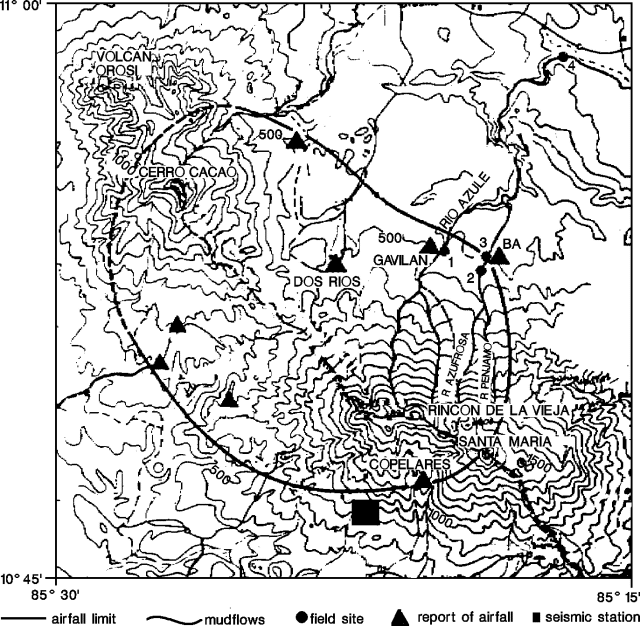 |
Figure 1. Map showing deposits from the 8 May 1991 phreatic eruption at Rincón de la Vieja. Site numbers correspond to cross-sections in figures 2 and 3, and table 1. Courtesy of OVSICORI. |
Table 1. Field observations of 8 May 1991 mudflow deposits from Rincón de la Vieja. Sites correspond to locations in figure 1. Courtesy of OVSICORI.
| Site | Distance | Deposit width | Channel width | Max. flow height | Deposit description |
| 1 | 7.2 km | 41 m | 10 m | 4-6 m | 1.65 m of erosion. |
| 2 | 6.6 km | 185 m | 12 m | 2-3 m | ~8 m deposited. |
| 3 | 7.0 km | 239 m | -- | 4-5 m | 2-60 cm of fine (2-16 mm) material. |
| 4 | 16.6 km | -- | -- | 2.15 m | Blocks (to 1.5 x 2.0 m) and tree trunks (50 cm diameter); 10-50-cm mantle of fine sediment. |
Mudflows traveled down the N flank (along the Quebrada Azufrosa, and Río Pénjamo), destroying two small bridges and cutting off access to the towns of Buenos Aires (~12 km NE) and Gavilán. Several smaller mudflows traveled down tributaries to the Río Azul (also to the N). Erosion occurred predominantly between 1,500 and 500 m elevation. Field observations of the mudflow deposits were made at several sites (figures 2 and 3; table 1). Park guards reported small quantities of sediment transported by the Río Colorado (S flank), but no effects on the ecosystem were observed.
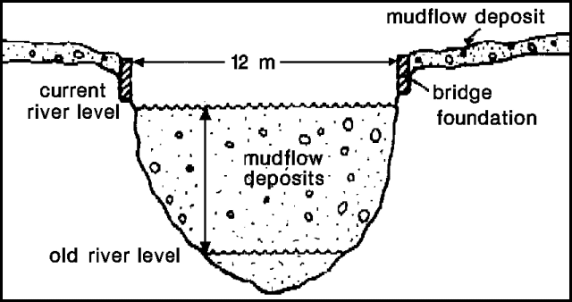 |
Figure 2. Cross-section of 8 May 1991 Rincón de la Vieja mudflow deposits near a bridge over the Río Azul. Site location is marked in figure 1. Courtesy of OVSICORI. |
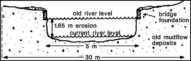 |
Figure 3. Cross-section of 8 May 1991 Rincón de la Vieja mudflow deposits near a bridge over the Río Pénjamo. Site location is marked in figure 1. Courtesy of OVSICORI. |
Blocks (to 40 x 50 cm) with impact craters and ejected lake sediments were found near the summit during a 9 May visit. Acidity and sediment-fall had variable impacts on nearby vegetation, ranging to complete defoliation. Fumarolic activity continued, as evidenced by a strong sulfur odor, eye irritation, and breathing difficulties near the crater. Rain collected 3 km S had a pH of 3.85.
Seismicity declined to 9 low-frequency recorded earthquakes/day (9 May), with only sporadic (1-2/day) events on later days.
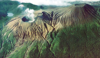
Geological Summary. Rincón de la Vieja, the largest volcano in NW Costa Rica, is a remote volcanic complex in the Guanacaste Range. The volcano consists of an elongated, arcuate NW-SE-trending ridge constructed within the 15-km-wide early Pleistocene Guachipelín caldera, whose rim is exposed on the south side. Sometimes known as the "Colossus of Guanacaste," it has an estimated volume of 130 km3 and contains at least nine major eruptive centers. Activity has migrated to the SE, where the youngest-looking craters are located. The twin cone of Santa María volcano, the highest peak of the complex, is located at the eastern end of a smaller, 5-km-wide caldera and has a 500-m-wide crater. A Plinian eruption producing the 0.25 km3 Río Blanca tephra about 3,500 years ago was the last major magmatic eruption. All subsequent eruptions, including numerous historical eruptions possibly dating back to the 16th century, have been from the prominent active crater containing a 500-m-wide acid lake located ENE of Von Seebach crater.
Information Contacts: E. Fernández S., Jorge Brenes M., V. Barboza M., and Tomás Marino H., Observatorio Vulcanológico y Sismológico de Costa Rica, Univ Nacional.