Report on Lascar (Chile) — May 1991

Bulletin of the Global Volcanism Network, vol. 16, no. 5 (May 1991)
Managing Editor: Lindsay McClelland.
Lascar (Chile) High crater temperatures detected by satellite
Please cite this report as:
Global Volcanism Program, 1991. Report on Lascar (Chile) (McClelland, L., ed.). Bulletin of the Global Volcanism Network, 16:5. Smithsonian Institution. https://doi.org/10.5479/si.GVP.BGVN199105-355100
Lascar
Chile
23.37°S, 67.73°W; summit elev. 5592 m
All times are local (unless otherwise noted)
On 8 January, radiant flux from the crater was near the highest levels since 1984, as demonstrated by Open Univ researchers using data from Landsat TM bands 5 and 7 (1.55-1.75 and 2.08-2.35 µm wavelength, respectively) (figure 8). The January images are the third in a set of three night images that have been used to provide improved estimates of radiated power output at Lascar. Previous estimates were based on daylight images (Glaze and others, 1989). No reflected sunlight is mingled with the thermal signal in night images, yielding more reliable thermal radiance values.
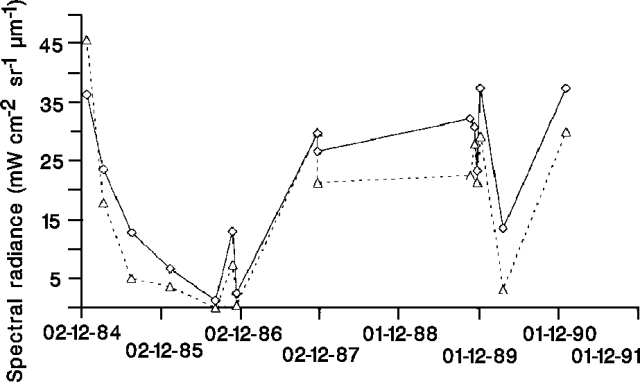 |
Figure 8. Spectral radiance from Lascar measured in 2 short-wavelength infrared bands, 2 December 1984-8 January 1991. Solid line, Landsat TM band 7 (2.08-2.35 µm); dashed line, Landsat TM band 5 (1.55-1.75 µm). Courtesy of D. Rothery and C. Oppenheimer. |
The following is from D. Rothery and C. Oppenheimer. "Two of the night images are shown in figure 9. The 12 November 1989 image shows a strong equidimensional radiant anomaly in a position that corresponds to the lava dome, with some isolated radiant pixels just beyond the edges that are probably sites of fumaroles. The 26 March 1990 image shows a much reduced radiant anomaly, following the 20 February 1990 explosive eruption.
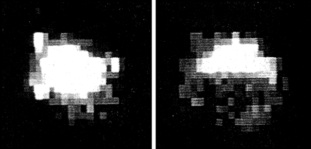 |
Figure 9. Night images of Lascar's active dome on 12 November 1989 (left) and 26 March 1990 (right), recorded at 2.08-2.35 µm wavelengths (Landsat TM band 7). N is toward the top. The individual pixels are ~30 m across. An image recorded on 8 January 1991 is almost identical to the 12 November 1989 image. Courtesy of D. Rothery and C. Oppenheimer. |
"Field observations at the summit of Lascar on 23-24 March and 4 April 1990 showed that there were sites of incandescence over regions of the collapsed dome, and that some fumaroles elsewhere were also incandescent. Temperatures of up to 940°C were estimated by the use of an infrared thermometer.
"The most recent image (8 January 1991, not shown here) is almost indistinguishable from the 12 November 1989 image, which suggests a return to earlier conditions."
Reference. Glaze, L.S., Francis, P.W., and Rothery, D.A., 1989, Measuring Thermal Budgets of Active Volcanoes; Nature, v. 338, p. 144-146.
Geological Summary. Láscar is the most active volcano of the northern Chilean Andes. The andesitic-to-dacitic stratovolcano contains six overlapping summit craters. Prominent lava flows descend its NW flanks. An older, higher stratovolcano 5 km E, Volcán Aguas Calientes, displays a well-developed summit crater and a probable Holocene lava flow near its summit (de Silva and Francis, 1991). Láscar consists of two major edifices; activity began at the eastern volcano and then shifted to the western cone. The largest eruption took place about 26,500 years ago, and following the eruption of the Tumbres scoria flow about 9000 years ago, activity shifted back to the eastern edifice, where three overlapping craters were formed. Frequent small-to-moderate explosive eruptions have been recorded since the mid-19th century, along with periodic larger eruptions that produced ashfall hundreds of kilometers away. The largest historical eruption took place in 1993, producing pyroclastic flows to 8.5 km NW of the summit and ashfall in Buenos Aires.
Information Contacts: D. Rothery and C. Oppenheimer, Open Univ.