Report on Unzendake (Japan) — June 1991

Bulletin of the Global Volcanism Network, vol. 16, no. 6 (June 1991)
Managing Editor: Lindsay McClelland.
Unzendake (Japan) Continued lava dome growth; debris flows to 7.5 km destroy houses; evacuations prevent more casualties
Please cite this report as:
Global Volcanism Program, 1991. Report on Unzendake (Japan) (McClelland, L., ed.). Bulletin of the Global Volcanism Network, 16:6. Smithsonian Institution. https://doi.org/10.5479/si.GVP.BGVN199106-282100
Unzendake
Japan
32.761°N, 130.299°E; summit elev. 1483 m
All times are local (unless otherwise noted)
Lava extrusion from Jigoku-ato crater began on 20 May. As growth of the dome continued, its E side, advancing down the steep upper flank, became structurally unstable, and collapse episodes triggered pyroclastic flows that traveled E down the Mizunashi River beginning 24 May. Pyroclastic flows were frequent in June, and continued as of mid-July (table 7). A large pyroclastic flow on 3 June traveled 4.6 km, reaching Kita-Kamikoba (a district of Shimabara), where 41 people were killed, and many houses destroyed. On 8 June, a pyroclastic flow advanced 5.5 km (the largest as of 24 July; figure 23), reaching the coast highway (57) and destroying additional houses. Evacuations prevented any injuries. An explosion from the crater at 2359 on 11 June ejected pumice, up to 10 cm in diameter, that fell 10 km NE. Ashfall was reported 250 km NE (at Matsuyama, Shikoku Is.). No further explosions had occurred by 24 July.
Table 7. Volcanic activity at Unzen along with injuries and major damage, and actions taken by the Coordinating Committee for the Prediction of Volcanic Eruptions, November 1990-24 July 1991. Courtesy of D. Shimozuru.
| Date | Volcanic Activity and Action by Committee |
| 17 Nov 1990 | Minor phreatic eruption; Official statement issued. |
| early Dec 1990 | Surface activity declines. |
| 12 Dec 1990 | Official statement issued, warning of future activity based on seismicity. |
| 13 May 1991 | Shallow earthquakes begin beneath crater. |
| 17 May 1991 | Official statement issued, warning of the appearance of lava. |
| 20 May 1991 | Lava appears in crater. |
| 24 May 1991 | First minor pyroclastic flow observed. |
| 26 May 1991 | Official statement issued, warning of debris flows and pyroclastic flows. One person injured by pyroclastic flow. |
| 31 May 1991 | Committee meeting held evaluating activity; setup of advanced HQ at Shimabara Volcano Obs. proposed to deal with rapid changes in activity. |
| 03 Jun 1991 | Pyroclastic flow kills 41 people, injures 11 people, and destroys 49 houses. |
| 08 Jun 1991 | Pyroclastic flow destroys 70 houses. |
| 11 Jun 1991 | Official statement issued from Shimabara. Block fall damages 11 houses and 53 cars. |
| mid-Jun 1991 | Continuous ash emission. |
| 19 Jun 1991 | Increase in pyroclastic-flow rate for 2 hours. |
| 30 Jun 1991 | Heavy rainfall caused large debris flow, destroying 87 houses and injuring one person. |
| 01-24 Jul 1991 | Dome growth, partial collapse, and pyroclastic flows continued. Flows became smaller and less frequent. Continuous ash emission from crater since 13 July. |
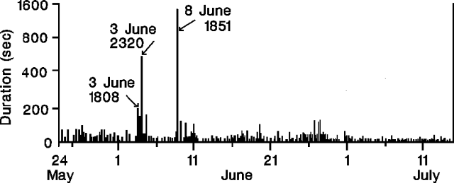 |
Figure 23. Seismically-recorded durations of pyroclastic-flow events at Unzen, May-mid July 1991. Courtesy of JMA. |
The pyroclastic-flow rate increased briefly on 19 June (between 1400 and 1600) with some of the larger flows traveling 2 km E. Larger pyroclastic flows were reported by the press on 26 and 27 June (~2.5 and 3.5 km in length, respectively). Ash elutriated from pyroclastic flows fell to the NE in June and July. By the end of June, the crater dome was about 150 x 250 m and 80 m thick, and pyroclastic flows were recorded seismically 10-20 times daily (figure 24).
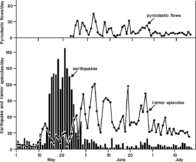 |
Figure 24. Daily number of earthquakes (bars), tremor episodes (lower curve), and pyroclastic-flow events (upper curve) at Unzen, May to mid-July 1991. Courtesy of JMA. |
On 30 June, heavy rainfall caused a large debris flow down the Mizunashi River, injuring one person, and destroying 87 houses [a total of 202 were damaged] near the coast (7.5 km E). The area affected by the flow was entirely within the evacuation zone designated in early June (a 5 x 5 km zone E of the summit, including parts of Shimabara and Fukae), with a pre-evacuation population of 12,395.
The dome continued to grow E, reaching 150 x 530 m and 80 m thick by 21 July. The eruption rate calculated from dome and pyroclastic deposit volumes was 0.3 x 10⁶ m3/day in June and July, although the rate of dome growth was higher in July. Continuous ash emission to 1,000 m height began 13 July, echoing a similar period in mid-June.
By mid-July, the month's longest pyroclastic flows had advanced
Summit seismicity was at lower levels in June and July than in May, with 230 earthquakes recorded in June, compared to 1959 in May. The monthly number of tremor episodes increased dramatically in June, apparently associated with small dome collapses.
An earthquake swarm, from 23 June to early July, was centered 18 km SW of the summit, at 10 km depth (figure 25). Nine of the earthquakes were felt. However, seismicity near the volcano and to its W (in Tachibana Bay) was lower in June and July than in previous months.
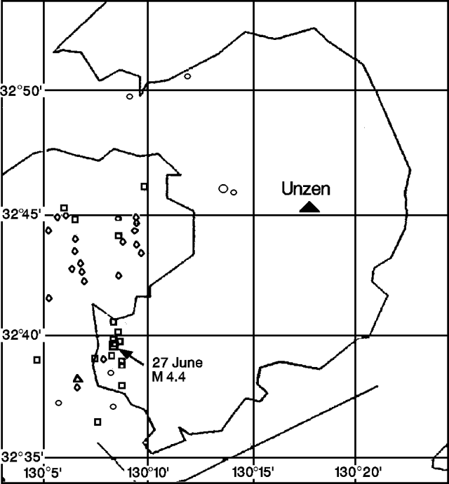 |
Figure 25. Epicenters of earthquakes near Unzen, June-mid July, 1991. A triangle marks the summit. Courtesy of JMA. |
Geological Summary. The massive Unzendake volcanic complex comprises much of the Shimabara Peninsula east of the city of Nagasaki. An E-W graben, 30-40 km long, extends across the peninsula. Three large stratovolcanoes with complex structures, Kinugasa on the north, Fugen-dake at the east-center, and Kusenbu on the south, form topographic highs on the broad peninsula. Fugendake and Mayuyama volcanoes in the east-central portion of the andesitic-to-dacitic volcanic complex have been active during the Holocene. The Mayuyama lava dome complex, located along the eastern coast west of Shimabara City, formed about 4000 years ago and was the source of a devastating 1792 CE debris avalanche and tsunami. Historical eruptive activity has been restricted to the summit and flanks of Fugendake. The latest activity during 1990-95 formed a lava dome at the summit, accompanied by pyroclastic flows that caused fatalities and damaged populated areas near Shimabara City.
Information Contacts: JMA; S. Nakada, Kyushu Univ; Kyodo News Service, Tokyo.