Report on Unzendake (Japan) — July 1991

Bulletin of the Global Volcanism Network, vol. 16, no. 7 (July 1991)
Managing Editor: Lindsay McClelland.
Unzendake (Japan) Continued dome growth and pyroclastic flow generation; dome history reviewed
Please cite this report as:
Global Volcanism Program, 1991. Report on Unzendake (Japan) (McClelland, L., ed.). Bulletin of the Global Volcanism Network, 16:7. Smithsonian Institution. https://doi.org/10.5479/si.GVP.BGVN199107-282100
Unzendake
Japan
32.761°N, 130.299°E; summit elev. 1483 m
All times are local (unless otherwise noted)
The dome in Jigoku-ato crater continued to grow in an easterly direction in July, at a rate of 0.3 x 10⁶ m3/day (figure 26). The magma supply rate remained unchanged in August, but the direction of growth became westerly. By 15 August, the dome was estimated to be 650 x 250 m and 130 m thick. On 19 July it had been 520 x 260 m, with a volume of 5.9 x 10⁶ m3.
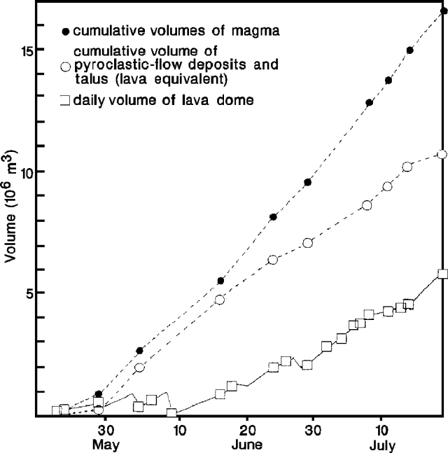 |
Figure 26. Cumulative volumes of magma erupted from Unzen, May-July 1991. Courtesy of S. Nakada. |
The number of seismically-detected pyroclastic flows and avalanches from the dome decreased in July (compared to June), showed a gradual increase late July-early August, then decreased suddenly on 12 August to only a few events/day. A total of 326 pyroclastic flows were recorded in July (down from 482 in June), and 155 during 1-15 August. Event durations were shorter than in previous months when flow signals occasionally lasted more than 300 seconds. The longest events lasted 140 seconds in July and 150 seconds in August.
Pyroclastic flows continued to travel as much as 2 km E down the Mizunashi River. None of the flows reached the evacuated areas of Shimabara and Fukae, which remained closed with 12,395 inhabitants relocated. Ash clouds from the larger pyroclastic flows rose 2 km, with ash falling mainly NE on Shimabara. Prevailing winds remained unchanged since May. Continuous ash emission from vents in the crater near the dome occurred in mid-July (16:06), and on 5-6, and 12 August, when the ash cloud rose 1.5 km. Explosive ejections of incandescent blocks to 100 m height were observed from midnight to 0200 on 12 August, presumably from a vent on the W end of the dome that continuously emitted ash throughout the day.
In contrast to the drop in pyroclastic flows on 12 August, the number of summit earthquakes and tremor episodes increased sharply on 11 August. This followed reduced seismic activity in June (230 recorded earthquakes) and July (133), compared to April (1959). More than 460 earthquakes had already been recorded in August by the 15th. Earthquake magnitudes were small and no shocks were felt, nor were changes in ground deformation detected by tiltmeters or EDM lines near the summit. Following the peak on 12 August, seismicity began to decrease. The increase in seismicity may be related to the incandescent ejections on 12 August, the active continuous ash emission, and the westward growth of the dome.
A man died on 8 August from burns suffered on 3 June, bringing the total casualties to 39 dead and three missing.
The following is a report from Setsuya Nakada on dome growth and morphology in June. "Large pyroclastic flows occurred on 3 and 8 June (figure 27), with volumes of about 0.7 x 10⁶, and 1 x 10⁶ m3, respectively. The E half of the lava dome collapsed during the eruption of the 3 June pyroclastic flow, leaving a 150-m-wide horseshoe-shaped depression opening to the E (figure 28). The volume of dome material left behind (referred to as W dome) was about 0.48 x 10⁶ m3. A new lava dome formed within the depression by 8 June, obtaining pre-3 June volumes.
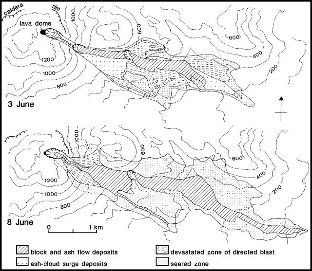 |
Figure 27. Distribution of the 3 and 8 June 1991 pyroclastic flow deposits at Unzen. From Nakada and Kobayashi (1991). |
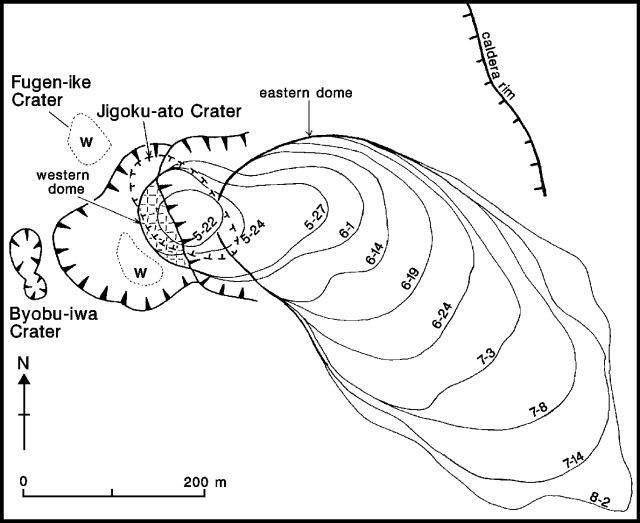 |
Figure 28. Growth pattern of the lava dome in Jigoku-ato Crater at Unzen, May-August, 1991. From Nakada and Kobayashi (1991). |
"Some of the 8 June pyroclastic flows, which reached 5.5 km beyond the crater, resulted from the direct eruption of magma from the vent. An extensive area of trees was burnt by the accompanying ash clouds. Pyroclastic surge (ash-cloud surge) deposits, such as those in the deposits from 3 June, were not clearly identified. Breadcrust bombs 5 cm in diameter were ejected to 3 km NE of the crater. Half of the W dome and the entire E dome (post-3 June material) were destroyed, widening the horseshoe-shaped depression to 200 m. About 0.15 x 10⁶ m3 of the W dome remained.
"Vulcanian explosions on 11 June ejected breadcrust and cauliflower bombs, up to 46 cm long, to 3 km distance. As a result, a depression 20-30 m in diameter formed within the crater, just above the former Jigoku-ato crater. On 17 June a continuous eruption column was observed rising from the W dome, for the first time since the start of lava extrusion.
"The E dome continued to grow and collapse along its E margin, filling a steep valley on the E slope of Jigoku-ato crater, then growing over the valley-fill deposits, a gentler surface than the original valley floor. The surface of the lava dome had the form of a petal with two lobes. These were created by extrusion near the summit of the E dome. After the middle of June, the lava surface traveled SE at a rate of 40 m/day, but the dome only lengthened a maximum of 10 m/day. By the end of June the horseshoe-shaped depression was filled with dome material, and lava blocks began to overflow NE onto the caldera floor."
Reference. Nakada, S., and Kobayashi, T., 1991, Lava dome and pyroclastic flows of the 1991 eruption at Unzen volcano: Bulletin of the Volcanological Society of Japan, v. 36, in press.
Geological Summary. The massive Unzendake volcanic complex comprises much of the Shimabara Peninsula east of the city of Nagasaki. An E-W graben, 30-40 km long, extends across the peninsula. Three large stratovolcanoes with complex structures, Kinugasa on the north, Fugen-dake at the east-center, and Kusenbu on the south, form topographic highs on the broad peninsula. Fugendake and Mayuyama volcanoes in the east-central portion of the andesitic-to-dacitic volcanic complex have been active during the Holocene. The Mayuyama lava dome complex, located along the eastern coast west of Shimabara City, formed about 4000 years ago and was the source of a devastating 1792 CE debris avalanche and tsunami. Historical eruptive activity has been restricted to the summit and flanks of Fugendake. The latest activity during 1990-95 formed a lava dome at the summit, accompanied by pyroclastic flows that caused fatalities and damaged populated areas near Shimabara City.
Information Contacts: JMA; S. Nakada, Kyushu Univ.