Report on Unzendake (Japan) — August 1991

Bulletin of the Global Volcanism Network, vol. 16, no. 8 (August 1991)
Managing Editor: Lindsay McClelland.
Unzendake (Japan) Continued lava dome extrusion and pyroclastic flows
Please cite this report as:
Global Volcanism Program, 1991. Report on Unzendake (Japan) (McClelland, L., ed.). Bulletin of the Global Volcanism Network, 16:8. Smithsonian Institution. https://doi.org/10.5479/si.GVP.BGVN199108-282100
Unzendake
Japan
32.761°N, 130.299°E; summit elev. 1483 m
All times are local (unless otherwise noted)
Lava extrusion continued at Jigoku-ato crater through mid-September, generating destructive pyroclastic flows that advanced down two valleys. More than 12,000 people remained evacuated and no new casualties were reported.
A summit seismic swarm that began 11 August peaked 12-13 August (figure 29), then gradually declined through the 19th. Incandescent block ejection was seen between 0000 and 0200 on 12 August, followed by continuous ash emission through the day. The number of seismically detected pyroclastic flows from the lava dome decreased suddenly to a few events daily on 12 August. A new lava dome, first recognized from the air on 13 August, emerged W of the former dome, and began to produce pyroclastic flows on 25 August. Pyroclastic flows had previously traveled down the Mizunashi River valley but those from the new dome (C dome; see below) moved ENE down the Oshigatani Valley, which extends N of and parallel to the Mizunashi, then joins it several kilometers downstream. Some of the larger pyroclastic flows from the new dome advanced 3 km down the Oshigatani valley from late August through mid-September, and pyroclastic surges burned vegetation. The mayor of Shimabara city ordered the evacuation of about 500 people from an area (Senbongi) 3.5 km NE of the dome on 31 August. Frequent pyroclastic flows during the afternoon of 3 September included one of about 1 x 10⁵ m3 volume that advanced down the Oshigatani Valley at 1611. The accompanying cloud rose about 1,500 m and ash fell to the N part of Shimabara city. Ashfalls from pyroclastic flow elutriation clouds disrupted traffic around Shimabara city throughout the following day; the cloud from a flow at 1311 was 2,500 m high.
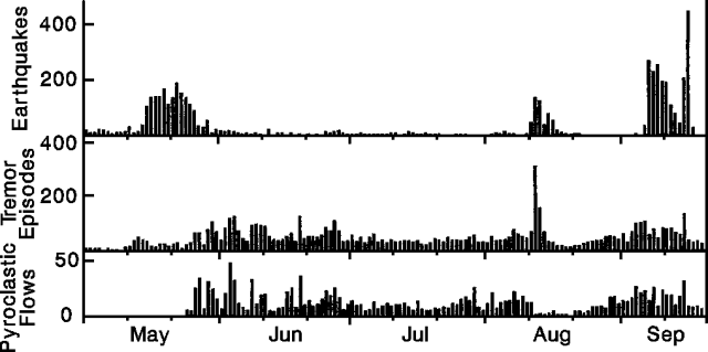 |
Figure 29. Daily numbers of earthquakes (top), tremor episodes (middle), and pyroclastic-flow events (bottom) recorded at Unzen, 1 May-20 September 1991. Courtesy of JMA. |
Another seismic swarm began beneath the crater on 6 September, and a pyroclastic flow that evening at 2121 advanced about 3.5 km down the Oshigatani Valley. Hypocenters and seismic wave characteristics were similar to those of mid-August, although the September swarm was more vigorous.
By 12 September, the lava dome had broken into numerous small blocks. Seismic activity declined through 14 September but increased again on the 15th. Seismometers near the summit began to record larger pyroclastic flows, with longer durations than any since 8 June, on 15 September at 1644 (150 seconds) followed by others at 1759 (120 seconds), 1842 (360 seconds), and the largest at 1854 (670 seconds). The latter moved down the Oshigatani valley, entered the Mizunashi valley, and continued to within 500 m of highway 57, a total of 5.5 km. The main body of the pyroclastic flow turned east into the Mizunashi valley, where it damaged 50 houses in Shimabara city, but the pyroclastic surge continued about 800 m southward, destroying 26 houses and 74 other buildings including those of a primary school (in Onokoba district, Fukae town). All of the affected area had previously been evacuated, so there were no casualties. The largest pyroclastic flow was associated with the collapse of a section of the new lava dome about 250 m wide, 300 m long, and 50 m thick, a volume exceeding 3 x 10⁶ m3. This is about 20% of the total volume of lava domes erupted to date, and 3 times the volume of material removed by the 8 June pyroclastic flow. Two days later, a new lobe had grown to 100 x 200 m and 30 m high (0.3 x 10⁶ m3/day), about twice the June-August extrusion rate (see below).
A total of 292 pyroclastic-flow events was recorded in August, down from 326 in July, but the more frequent episodes toward mid-September raised that month's total to 310 as of the 17th. September earthquake counts had reached 2075 through the 17th, up from 559 in August and 133 in July.
The following, from Setsuya Nakada, describes eruption products through early September.
The size and frequency of pyroclastic flows had decreased until July, and travel distances were almost always <2 km. However, collapse episodes from the E lava dome remained frequent and lava blocks had filled the narrow headwaters of the Mizunashi River, along which the 3 and 8 June pyroclastic flows had descended. As a result, cliffs along the valley disappeared, and valley-fill deposits (talus) became thick enough to act as a cushion to soften the shock of falling blocks. The E dome flowed southeastward on the valley-fill deposits. After the end of June, the horseshoe-shaped depression had filled with dome materials, and lava blocks began to fall northeastward onto the floor of Myoken caldera (figure 30). They filled the E end of the floor with talus, which overflowed the caldera rim at the end of July. Lava blocks then fell down the E and NE flanks as pyroclastic flows and their paths widened northeastward. Some reached the N bank of the Mizunashi River. The E margin of the E dome widened; because the NE slope under the dome was steeper than the SE slope, the northern half of the E dome migrated northeastward, while the southern half did not move and solidified. By the middle of August, the caldera rim NE of the dome had been eroded away by the falling lava blocks.
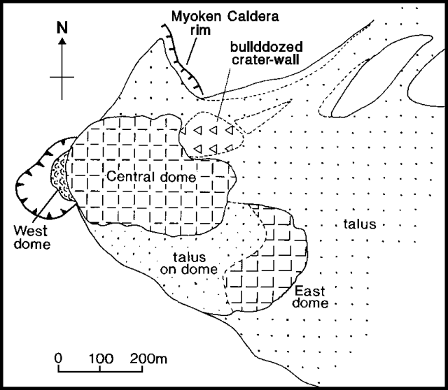 |
Figure 30. Sketch map of Unzen's lava dome, 8 September 1991. Courtesy of Setsuya Nakada. |
At the beginning of August, the ash-laden plume from the small vent at the northern base of the remnant W dome became stronger, and new lava was extruded on the western part of the E dome. On 5 August, many bubbles were observed coming from an old water-filled crater near the W dome. The small explosions that took place from the W dome on 12 August (see above) enlarged the vent to 20 m across and built a tuff cone around it. The E dome temporarily thickened for a few days prior to the new lava extrusion; the western part of the E dome, just above the former Jigoku-ato Crater, had swelled vertically. By the time new lava appeared 13 August, magma supply into the E dome had stopped, since the E dome did not lengthen and the surface of the dome did not move eastward (figure 31). It was difficult to accurately estimate the change in magma supply rate; talus and pyroclastic flows were deposited over an extensive area with irregular topography, which causes difficulties in calculating volumes of talus plus pyroclastic deposits.
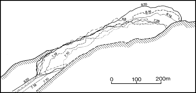 |
Figure 31. Tracings of photographs from a fixed point about 4.4 km from Unzen's E lava dome, illustrating its growth 10 July-20 August 1991. Courtesy of Setsuya Nakada. |
At the end of August, the new dome (central, or C dome) was 375 m long, 275 m wide, and 60-80 m high. The C dome grew eastward and northeastward, keeping a constant thickness. It covered the E dome and talus, plus a part of the old volcanic edifice, which was bulldozed by the growing dome from the former crater wall to the caldera rim. Talus also formed on the E dome. At the end of August, the volume of C dome was about 4 x 10⁶ m3 and the total volume of the domes was about 12 x 106 m3. The resulting dome growth rate is about 0.15 x 10⁶ m3/day for 8 June-28 August.
Lava blocks fell down the E and NE margins of C dome into the Oshigatani Valley, forming pyroclastic flows beginning 25 August. The upstream area of the valley was the source area for lahars on 30 June. The pyroclastic flows traveled a maximum distance of 3 km from the dome, and had associated ash-cloud surge and seared zones like those of 3 and 8 June (figure 32). Flows moving down the Oshigatani Valley changed course southeastward when they encountered a high point dividing the valley and a residential area. Ash-cloud surges climbed the barrier, burning or searing trees, but block-and-ash flows did not. The devastated area was widest for pyroclastic flows that took place within the first week. By mid-September, Oshigatani Valley had been almost filled by pyroclastic-flow deposits.
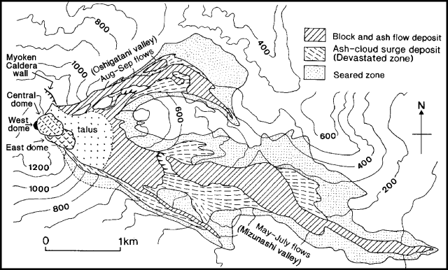 |
Figure 32. Map showing the distribution of pyroclastic flows from Unzen as of 9 September 1991. Deposits from lahars, which occurred mainly on 30 June, are omitted. Courtesy of Setsuya Nakada. |
Average speeds of pyroclastic flows were estimated using travel distances observed by Ground Self-Defense Force radar and durations of tremor signals. The higher the average speed of a pyroclastic flow, the longer its travel distance: about 100 km/hour for flows reaching 3 km distance and 50 km/hour for flows 1 km long. The average speed of a pyroclastic flow at the end of August was estimated at 93 km/hour using the time lag between the start of the tremor signal and the time when the seismometer was broken by the flow.
Geological Summary. The massive Unzendake volcanic complex comprises much of the Shimabara Peninsula east of the city of Nagasaki. An E-W graben, 30-40 km long, extends across the peninsula. Three large stratovolcanoes with complex structures, Kinugasa on the north, Fugen-dake at the east-center, and Kusenbu on the south, form topographic highs on the broad peninsula. Fugendake and Mayuyama volcanoes in the east-central portion of the andesitic-to-dacitic volcanic complex have been active during the Holocene. The Mayuyama lava dome complex, located along the eastern coast west of Shimabara City, formed about 4000 years ago and was the source of a devastating 1792 CE debris avalanche and tsunami. Historical eruptive activity has been restricted to the summit and flanks of Fugendake. The latest activity during 1990-95 formed a lava dome at the summit, accompanied by pyroclastic flows that caused fatalities and damaged populated areas near Shimabara City.
Information Contacts: JMA; S. Nakada, Kyushu Univ; M. Takahashi, SI; Yomiuri Shinbun, Tokyo.