Report on Kilauea (United States) — August 1991

Bulletin of the Global Volcanism Network, vol. 16, no. 8 (August 1991)
Managing Editor: Lindsay McClelland.
Kilauea (United States) Continued lava flow into sea; lava pond overflows; magma intrusion
Please cite this report as:
Global Volcanism Program, 1991. Report on Kilauea (United States) (McClelland, L., ed.). Bulletin of the Global Volcanism Network, 16:8. Smithsonian Institution. https://doi.org/10.5479/si.GVP.BGVN199108-332010
Kilauea
United States
19.421°N, 155.287°W; summit elev. 1222 m
All times are local (unless otherwise noted)
Lava . . . continued to enter the ocean at two main sites through August (figure 79). By the end of the month, numerous breakouts from the tube system had reduced the volume of lava reaching the sea. Flows produced by major breakouts at ~180 and 340 m (600 and 1,100 ft) elevation spread over the W third of the lava field. Most remained on older lava, but a few lobes reached the field's W edge and ignited small brush fires in the remnants of the Royal Gardens subdivision. One flow from the breakout at 180 m reached 20 m elevation in early August.
Since at least January, a small lava pond has been continuously active in the bottom of Pu`u `O`o crater, covering ~20% of the crater floor on its E side. By April, the pond was circular and surrounded by levees. During the evening of 27 August, bright glow was visible over Pu`u `O`o, and a nearby seismometer recorded frequent bursts of higher amplitude tremor lasting 1-3 minutes. Overflights the next morning revealed that the pond had overflowed its levees, covering the entire crater floor with several meters of active lava that had a thin, frequently overturning, crust. Lava periodically drained back to its former level, remaining confined within the original pond until the next overflow. Similar activity continued through the end of the month. Crater depth remained roughly 80 m.
Seismicity in August included the upper East rift zone's third intrusive swarm since December 1990. More than 200 shallow summit microearthquakes were registered between 1100 and 1200 on 21 August. Earthquake counts quickly declined during the next hour, but elevationated levels of seismicity . . . continued through the next day. The largest concentration of events appeared to be centered just SE of the caldera, and very few occurred beyond Hiiaka crater, 4.5 km from the caldera rim. Most of the month's seismicity in the summit/upper east rift area occurred during the swarm.
Earthquake epicenters since December 1990 (figure 80) have been concentrated in several clusters, the largest of which were associated with the period's three intrusive episodes. The three swarms occurred in different portions of what geophysicists infer to be the same shallow (<5 km deep) structure between the summit and the East rift zone, suggesting a significant role for the summit in the current East rift eruption. During the early December swarm earthquakes were located from the summit roughly 6 km downrift (to Pauahi crater). The largest concentration of events was in the SE part of the caldera, perhaps extending a short distance into the rift zone (toward the Chain of Craters). The March activity occurred away from the summit, with the majority of located events between Pauahi and Mauna Ulu, roughly 3 km farther downrift. Following the early December seismicity and a long-period summit swarm late in the month, seismicity increased between the summit and Hiiaka crater. The same segment of the uppermost East rift zone has consistently shown low levels of shallow seismicity throughout Kupaianaha vent's post-1986 eruptive activity. After the March swarm, seismic activity along this rift segment appears to have increased further, and the August swarm was largely confined to this area.
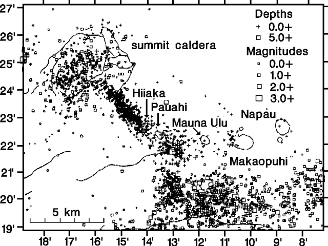 |
Figure 80. Plot of earthquake epicenters in Kīlauea's summit, upper to middle East rift zone, and south flank areas, December 1990-11 September 1991. Some of the larger craters are labeled. The eruption's two currently active vents, Pu`u `O`o and Kupaianaha, are off the map ~3 and 6 km ENE of Napau Crater. Courtesy of HVO. |
Geological Summary. Kilauea overlaps the E flank of the massive Mauna Loa shield volcano in the island of Hawaii. Eruptions are prominent in Polynesian legends; written documentation since 1820 records frequent summit and flank lava flow eruptions interspersed with periods of long-term lava lake activity at Halemaumau crater in the summit caldera until 1924. The 3 x 5 km caldera was formed in several stages about 1,500 years ago and during the 18th century; eruptions have also originated from the lengthy East and Southwest rift zones, which extend to the ocean in both directions. About 90% of the surface of the basaltic shield volcano is formed of lava flows less than about 1,100 years old; 70% of the surface is younger than 600 years. The long-term eruption from the East rift zone between 1983 and 2018 produced lava flows covering more than 100 km2, destroyed hundreds of houses, and added new coastline.
Information Contacts: T. Mattox and P. Okubo, HVO.