Report on Kikai (Japan) — October 1991
Bulletin of the Global Volcanism Network, vol. 16, no. 10 (October 1991)
Managing Editor: Lindsay McClelland.
Kikai (Japan) Continued thermal activity; plume from new crater
Please cite this report as:
Global Volcanism Program, 1991. Report on Kikai (Japan) (McClelland, L., ed.). Bulletin of the Global Volcanism Network, 16:10. Smithsonian Institution. https://doi.org/10.5479/si.GVP.BGVN199110-282060
Kikai
Japan
30.793°N, 130.305°E; summit elev. 704 m
All times are local (unless otherwise noted)
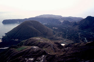
"Geologists visited Satsuma-Iwo-jima 7-10 November. Several large fumarole fields exist within and around the 300-m-diameter crater. Accessible fumaroles had temperatures ranging from 100 to > 800°C. Several types of sampling were conducted to geochemically characterize the emissions. GSJ geologists had used a COSPEC to measure a maximum SO2 flux of 500 t/d in May 1990, similar to . . . 15 years previously. In addition to geochemical samples, a portable spectrometer was used to collect spectra of various features to provide ground truth for satellite images of the region. The major summit geomorphological change since last year's visit by GSJ geologists was the formation of a 15 x 30 m pit crater in the SE corner of the main summit crater. Local silica-mine workers first noticed the new pit crater in June or July 1991. A large plume was continuously emitted from the pit crater."
Geological Summary. Multiple eruption centers have exhibited recent activity at Kikai, a mostly submerged, 19-km-wide caldera near the northern end of the Ryukyu Islands south of Kyushu. It was the source of one of the world's largest Holocene eruptions about 6,300 years ago when rhyolitic pyroclastic flows traveled across the sea for a total distance of 100 km to southern Kyushu, and ashfall reached the northern Japanese island of Hokkaido. The eruption devastated southern and central Kyushu, which remained uninhabited for several centuries. Post-caldera eruptions formed Iodake (or Iwo-dake) lava dome and Inamuradake scoria cone, as well as submarine lava domes. Recorded eruptions have occurred at or near Satsuma-Iojima (also known as Tokara-Iojima), a small 3 x 6 km island forming part of the NW caldera rim. Showa-Iojima lava dome (also known as Iojima-Shinto), a small island 2 km E of Satsuma-Iojima, was formed during submarine eruptions in 1934 and 1935. Mild-to-moderate explosive eruptions have occurred during the past few decades from Iodake, a rhyolitic lava dome at the eastern end of Satsuma-Iojima.
Information Contacts: R. Andres, Michigan Technological Univ; H. Shinohara, R. Symonds, and B. Ritchie, GSJ.