Report on Kilauea (United States) — October 1991

Bulletin of the Global Volcanism Network, vol. 16, no. 10 (October 1991)
Managing Editor: Lindsay McClelland.
Kilauea (United States) New east rift fissure vents
Please cite this report as:
Global Volcanism Program, 1991. Report on Kilauea (United States) (McClelland, L., ed.). Bulletin of the Global Volcanism Network, 16:10. Smithsonian Institution. https://doi.org/10.5479/si.GVP.BGVN199110-332010
Kilauea
United States
19.421°N, 155.287°W; summit elev. 1222 m
All times are local (unless otherwise noted)
New fissure vents opened on 8 November between the East rift zone's two active vents (Kupaianaha and Pu`u `O`o), feeding aa flows that advanced into the remnants of Royal Gardens subdivision (figure 81). Lava from Kupaianaha vent continued to emerge from tubes on the W side of the flow field, but the lava pond in Pu`u `O`o drained rapidly and was no longer visible by 11 November.
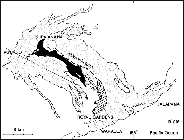 |
Figure 81. Lava produced by Kīlauea's East Rift eruption, 1983-91 (stippled). The area of October surface lava flow activity from Kupaianaha vent is indicated by a diagonal pattern. Arrows indicate flow in tubes. Crosses mark the discontinuous fissure vents that opened between Pu`u `O`o and Kupaianaha on 8 November. Lava extruded by the new fissures as of mid-November is black. Courtesy of HVO. |
October activity. Lava from Kupaianaha vent moved downslope through tubes and emerged onto the W side of the flow field through October, feeding surface flows between ~400 m (1,300 ft) altitude and the coastal plain (figure 81). Lava that broke out of the main (Wahaula) tube at ~270 m (900 ft) destroyed one of the remaining houses in Royal Gardens subdivision on 27 October. Breakouts behind the flow front destroyed a nearby house 4 days later. The two destroyed houses, and two others that remained intact nearby, had been isolated by 1990 flows. Three houses in Royal Gardens remained inhabited at the end of October, one within 1 km of recent flows. In the past few months, flows in this area have extended the margin of the lava field ~700 m to the W, but have been blocked from reaching the ocean by 1989 lava.
Kupaianaha vent's lava pond remained frozen during October. During an 11 October overflight, two small skylights were seen next to the former pond: one in large cracks on the faulted, uprift side of the pond, and the other (emitting heavy fume) in the crater wall on the pond's SE side. The lava pond in Pu`u `O`o crater fluctuated between 1 and 10 m below the crater floor, 36 m below the 1986 spillway. The vigorous degassing episodes noted in previous months were not as common in October. Fieldwork on 25 October revealed a large pile of spatter in the former spillway, and tephra that included Pele's tears and reticulite were found along the downrift side of the crater rim (figure 82).
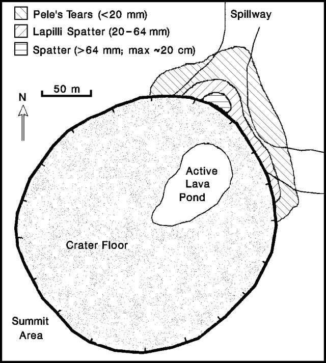 |
Figure 82. Pu`u `O`o's crater floor, 25 October 1991. Tephra deposits in and around the 1986 spillway are shown. Periodic overflows of the active pond have coated much of the crater floor. Sketch by Mauro Coltelli; courtesy of HVO. |
Fissure eruption beginning 8 November. Seismic activity preceding the fissure eruption began with a short burst of shallow summit tremor on 8 November at about 0200, followed by small earthquakes that became frequent beneath the summit and upper East rift zone. The summit began to deflate at about 0430 as magma moved into the upper east rift. The fissures opened from W to E starting before 0445, with the easternmost fissures opening about 0500. Glow was reported just downrift from Pu`u `O`o at 0450. A plume of dust rose roughly 400 m above Pu`u `O`o at about 0715, as the crater floor collapsed. Helicopter pilots reported that at 0745 the pond at Pu`u `O`o had drained and a fissure eruption was underway, initially from a discontinuous series of fissures ~1.5 km long. Volcanic tremor intensified beneath the summit and in the vent area that night. The next day, lava fountains were <5 m high, and by the morning of 10 November the eastern fissures were feeding lava directly into a pond nearly 15 m deep. Late that day, the pond was stagnant NE of the fissures, but to the SE, two wide channelized aa flows were moving slowly toward the coast. The pond had drained into a rapidly advancing aa flow by the morning of 11 November, and fountains had again emerged above the subsided pond.
By 1600 on 11 November, the flows had advanced 3 km to ~400 m (1,300 ft) altitude, at the top of Royal Gardens subdivision, and trees were burning along the subdivision's E side. Two days later, the flows had advanced another 200 m into Royal Gardens. As of 14 November, the flow front was stagnant, but new aa flows were advancing atop earlier lava, and were particularly active ~125 m above the multilobate terminus. Lava was issuing quietly into a channel ~30 m wide that fed the flows downslope, but fountaining had stopped. The deflation rate at the summit had slowed during 8-10 November, accelerated on 11 November, but was slowing again as of the 14th. Volcanic tremor, indicating magma migration, continued at moderate levels beneath the summit and upper East rift zone, but amplitudes decreased on 13 November.
The level of lava in the tube extending from Kupaianaha to the flat area near the coast has dropped somewhat since the onset of fissure activity. Pahoehoe flows originating at Kupaianaha remained active on the E side of Royal Gardens subdivision on 14 November, but other Kupaianaha flows had stagnated along the coastal plain. [see also 16:11]
Geological Summary. Kilauea overlaps the E flank of the massive Mauna Loa shield volcano in the island of Hawaii. Eruptions are prominent in Polynesian legends; written documentation since 1820 records frequent summit and flank lava flow eruptions interspersed with periods of long-term lava lake activity at Halemaumau crater in the summit caldera until 1924. The 3 x 5 km caldera was formed in several stages about 1,500 years ago and during the 18th century; eruptions have also originated from the lengthy East and Southwest rift zones, which extend to the ocean in both directions. About 90% of the surface of the basaltic shield volcano is formed of lava flows less than about 1,100 years old; 70% of the surface is younger than 600 years. The long-term eruption from the East rift zone between 1983 and 2018 produced lava flows covering more than 100 km2, destroyed hundreds of houses, and added new coastline.
Information Contacts: T. Mattox and P. Okubo, HVO.