Report on Westdahl (United States) — November 1991
Bulletin of the Global Volcanism Network, vol. 16, no. 11 (November 1991)
Managing Editor: Lindsay McClelland.
Westdahl (United States) Lava flows and tephra from 8-km NE-flank fissure
Please cite this report as:
Global Volcanism Program, 1991. Report on Westdahl (United States) (McClelland, L., ed.). Bulletin of the Global Volcanism Network, 16:11. Smithsonian Institution. https://doi.org/10.5479/si.GVP.BGVN199111-311340
Westdahl
United States
54.516°N, 164.65°W; summit elev. 1563 m
All times are local (unless otherwise noted)
Westdahl erupted at approximately 1700 on 29 November, sending a plume of steam and ash to more than 6 km altitude. The FAA immediately rerouted air traffic to the Pacific side of the eastern Aleutians to avoid encounters with the plume, which drifted NNE over the Bering Sea.
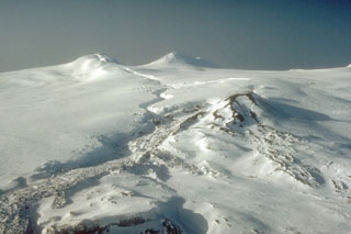
Video and still photographs from 30 November (courtesy of the U.S. Coast Guard, Peninsula Airways, and several civilians) show that the eruption occurred from a fissure, ~8 km long, extending down the NE flank from Westdahl Peak to an elevation of ~760 m. Several large craters and gaping sinuous cracks, parallel to the fissure, formed in snow and ice fields, probably by collapse due to melting. Ash venting occurred discontinuously along most of the fissure's length, but lava fountaining was concentrated along the lower few kilometers. Several streams of fluid lava traveled E down at least two steep-walled drainages. By the second day of the eruption, the principal lava flow had moved a distance of about 4 km. Based on observations by AVO staff from a Coast Guard C-130 aircraft on 3 December, the very active flow front was 1.5 km wide, 5-10 m high, and ~7 km from the vent [figure 5]. The lava flow consisted of blocky gray aa, and widened as it reached the broad valley draining to the Pacific Ocean. As of 3 December, the front was about 10 km from the ocean. Also observed on the overflight was a dark-colored debris-flow deposit that extended to the Pacific. Streams draining the NE flank were muddy and steaming slightly when observed on 30 November and 3 December. Lava fountaining was visible, during clear weather, through 10 December, and lava flows remained active on the NE flank.
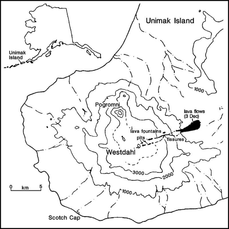 |
Figure 5. Sketch map of the SW part of Unimak Island, showing the eruption vents and lava flow from the Westdahl eruption as of 3 December 1991. Contour interval, 1,000 feet (about 300 m). Printed by permission of the Alaska Volcano Observatory. [Originally in 17:01] |
Satellite imagery and pilot observations through mid-December indicated that the steam plume, periodically containing small quantities of ash, rose to as much as 7 km altitude and was preferentially carried NE. On 30 November, residents of False Pass, 90 km NE, reported ash-laden skies, fine ash deposition, and a strong sulfur smell that lasted into the night. Similar strong sulfur odors were reported by pilots up to several hundred kilometers inland. Light ashfall occurred again at False Pass on 9 and 12 December, and distant roaring and rumbling were occasionally heard at night through mid-December. No ash was reported in Cold Bay (145 km NE).
[No seismometers are installed on Westdahl, so information about seismicity associated with the eruption is limited. Data from the nearest seismic station, 170 km ENE of Westdahl (at Dutton), included six earthquakes of M 2.8-3.1 between 1100 and 1940 on 29 November. S-P values were consistent with epicenters in the Westdahl area, as were those recorded at Sand Point, 275 km ENE. The Dutton station also detected a tremor-like signal, different from typical noise at the site, between 1500 and 1949 on 29 November. (Originally in 17:01).]
Further Reference. Swanson, S., 1990, Westdahl, in Wood, C. and Kienle, J., Volcanoes of North America: Cambridge University Press, p. 45-46.
Geological Summary. Westdahl is a broad glacier-covered volcano occupying the SW end of Unimak Island. Two peaks protrude from the summit plateau, and a new crater formed in 1978 cuts the summit icecap. The volcano has a somewhat of a shield-like morphology and forms one of the largest volcanoes of the Aleutian Islands. The sharp-topped, conical Pogromni stratovolcano, 6 km N, rises several hundred meters higher than Westdahl, but is moderately glacially dissected and presumably older. Many satellitic cones of postglacial age are located along a NW-SE line cutting across the summit of Westdahl. Some of the historical eruptions attributed to the eroded Pogromni may have originated instead from Westdahl (Miller et al. 1998). The first historical eruption occurred in 1795. An 8-km-long fissure extending east from the summit produced explosive eruptions and lava flows in 1991.
Information Contacts: AVO; SAB; AP.