Report on Kanlaon (Philippines) — December 1991
Bulletin of the Global Volcanism Network, vol. 16, no. 12 (December 1991)
Managing Editor: Lindsay McClelland.
Kanlaon (Philippines) Small ash emission
Please cite this report as:
Global Volcanism Program, 1991. Report on Kanlaon (Philippines) (McClelland, L., ed.). Bulletin of the Global Volcanism Network, 16:12. Smithsonian Institution. https://doi.org/10.5479/si.GVP.BGVN199112-272020
Kanlaon
Philippines
10.4096°N, 123.13°E; summit elev. 2422 m
All times are local (unless otherwise noted)
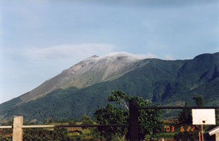
Mild ash emission occurred from Canlaon on 8 January [1992] from 1405 to 1426. The light-gray ash clouds rose 600-800 m above the crater before drifting SW. Ashfall was confined to the upper flanks. During the ash emission, the seismograph at Canalon City Observatory recorded short-duration harmonic tremor with a maximum double amplitude of 10 mm, and 15 volcanic earthquakes. Seismic activity then gradually decreased; 8 volcanic earthquakes were recorded shortly after the eruption, but only two small volcanic events were detected between 1600 and 0600 the next morning. Steam emission also gradually decreased from voluminous (filling 80% of the crater) to moderate (40% of the crater filled). As of 12 January, activity was characterized by weak to moderate white vapor emission, with plume heights of 50->100 m and vapor filling 20-40% of the crater. Prevailing winds carried the plume SW and SSW.
Seismic activity had remained at background levels (<5 events/day) from 15 February 1991 through the day before the eruption, and pre-eruption steam emission varied from wispy to weak. Geologists believe that the eruption was triggered by ground water suddenly contacting hot rock beneath the summit crater.
A PHIVOLCS quick-response team left for Canlaon on 9 January. They issued no recommendation for evacuation, but advised residents of the area not to venture within the previously delineated danger zone (5 km radius) and to heed precautionary and safety measures.
Geological Summary. Kanlaon volcano (also spelled Canlaon) forms the highest point on the Philippine island of Negros. The massive andesitic stratovolcano is covered with fissure-controlled pyroclastic cones and craters, many of which are filled by lakes. The largest debris avalanche known in the Philippines traveled 33 km SW from Kanlaon. The summit contains a 2-km-wide, elongated northern caldera with a crater lake and a smaller but higher active vent, Lugud crater, to the south. Eruptions recorded since 1866 have typically consisted of phreatic explosions of small-to-moderate size that produce minor local ashfall.
Information Contacts: PHIVOLCS.

