Report on Unzendake (Japan) — December 1991

Bulletin of the Global Volcanism Network, vol. 16, no. 12 (December 1991)
Managing Editor: Lindsay McClelland.
Unzendake (Japan) Continued dome extrusion and pyroclastic flows; vigorous seismicity; more than 8,000 still evacuated
Please cite this report as:
Global Volcanism Program, 1991. Report on Unzendake (Japan) (McClelland, L., ed.). Bulletin of the Global Volcanism Network, 16:12. Smithsonian Institution. https://doi.org/10.5479/si.GVP.BGVN199112-282100
Unzendake
Japan
32.761°N, 130.299°E; summit elev. 1483 m
All times are local (unless otherwise noted)
The following is from Setsuya Nakada, with additional information from JMA.
Lava domes continued to grow through early January, with growth occurring both exogenously and endogenously (figures 35 and 36). Talus from the domes buried their SE slopes.
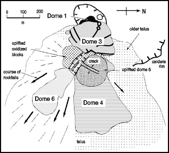 |
Figure 35. Oblique view of the dome complex at Unzen, 7 January 1992. Extrusion of dome 6 began in early December. Courtesy of Setsuya Nakada. |
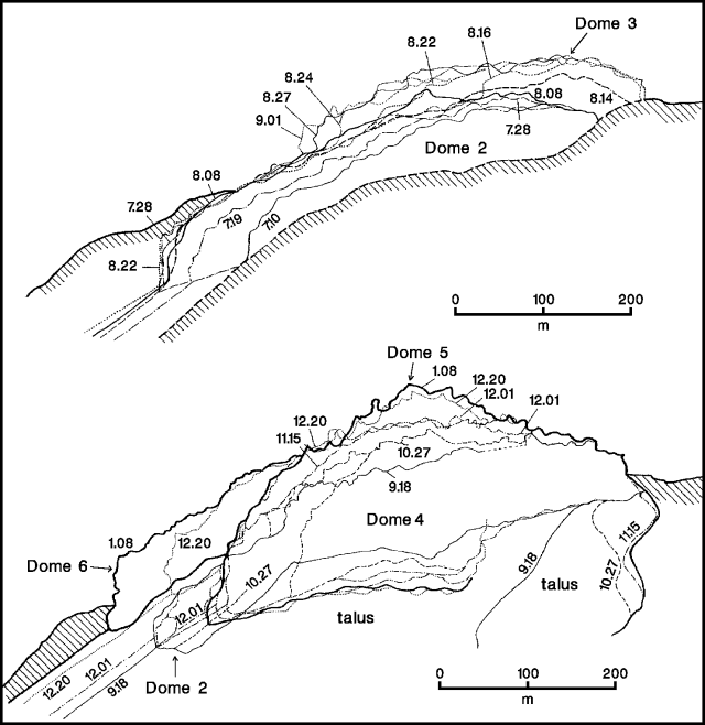 |
Figure 36. Successive dome surfaces traced from photographs taken from a fixed point about 4.4 km N of the dome complex at Unzen, illustrating growth July-early September 1991 (top) and September 1991-early January 1992 (bottom). Courtesy of Setsuya Nakada. |
Extrusion of a new lava dome (6) toward the SE began in early December. By late December, its initial 2-lobed petal structure had become poorly defined and its advance had nearly stopped, as lava blocks began falling directly from the head of the dome, eroding the southern margin of dome 4. On 7 January, dome 6 was about 370 m long, 180 m wide, and 80 m high. Collapsed dome material eroded and buried dome 2, which was no longer visible by mid-December.
Dome 5, emerging since 21 November at the head of dome 4, grew upward about 50 m in mid-December to become the highest of the six 1991 domes. Its peak, at about 1,360 m above sea level, had reached the height of the volcano's summit (Fugen-dake). A crack formed in the top of dome 5, roughly perpendicular to the NW-SE-trending graben that developed on the lava-supply vent and widened in late December.
Pyroclastic flows, generated mainly from dome 6, advanced as much as 2.5 km SE down the Mizunashi and Tansansui valleys. The number of seismically recorded pyroclastic-flow events increased from 149 in November to 395 in December, continuing at a rate of 10-20/day through mid-January (figure 37). Ash clouds generated by pyroclastic flows, reddish brown to dark brown early in the eruption, had become milky colored, and those from the largest flows reached 2 km height. Failure of dome portions as large as 104-105 m3 in volume seldom triggered pyroclastic flows, but remained simple rockfalls. This suggested to geologists a decline in the fragmentation force (and perhaps the auto-explosivity) of falling lava blocks, probably implying a decreased pore pressure.
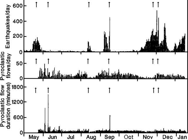 |
Figure 37. Daily number of recorded earthquakes (top), with number (middle) and duration (bottom) of seismically recorded pyroclastic flows at Unzen, May 1991-early January 1992. Arrows represent the first appearance of domes 1-6. Courtesy of JMA. |
Plumes from the NW margin of the former Jigoku-ato Crater had become weaker and less frequent by mid-December, and ash-laden columns were rare. White-bluish, sulfur-rich, acidic gas was discharged continuously from Jigoku-ato through cracks in dome 3. Strong steam-rich gas emission accompanied the bluish plumes, especially the day after heavy rains. The SO2 discharge rate from Jigoku-ato ranged from 50 to 350 metric tons/day (t/d), probably averaging about 200 t/d for June-December 1991. The Cl/SO4 ratio of water-soluble ash components increased from 0.5 in May to 10-15 in early August, then decreased to lower levels (analyses by the Kusatsu-Shirane Volcano Observatory, Tokyo Institute of Technology).
The seismic swarm that began beneath the dome on 24 October was continuing as of mid-January, becoming the longest and most vigorous since lava extrusion began in May. Earthquakes recorded in December totaled 4253, the highest monthly figure since activity began to increase in July 1990 (table 8 and figure 38).
Table 8. Monthly seismicity and number of seismically recorded pyroclastic flow events at Unzen, 1991. Courtesy of JMA.
| Month | Earthquakes | Small tremor episodes | Pyroclastic flows |
| Jan 1991 | 571 | 15 | 0 |
| Feb 1991 | 937 | 139 | 0 |
| Mar 1991 | 735 | 99 | 0 |
| Apr 1991 | 727 | 176 | 0 |
| May 1991 | 1957 | 696 | 143 |
| Jun 1991 | 230 | 1509 | 492 |
| Jul 1991 | 133 | 867 | 326 |
| Aug 1991 | 559 | 1285 | 292 |
| Sep 1991 | 2102 | 1237 | 521 |
| Oct 1991 | 208 | 902 | 438 |
| Nov 1991 | 3933 | 664 | 149 |
| Dec 1991 | 4253 | 1331 | 395 |
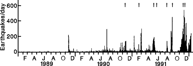 |
Figure 38. Daily number of recorded earthquakes at Unzen, 1989-early January 1992. The first two arrows mark phreatic eruptions on 17 November 1990 and 12 February 1991; the remaining six represent the first appearance of lava domes 1-6. Courtesy of JMA. |
The evacuation zone has remained almost unchanged since September, with a total of 8,125 evacuees in December (5,526 from Shimabara city, 2,599 from Fukae town). Shimabara Railway traffic resumed on 27 December.
Geological Summary. The massive Unzendake volcanic complex comprises much of the Shimabara Peninsula east of the city of Nagasaki. An E-W graben, 30-40 km long, extends across the peninsula. Three large stratovolcanoes with complex structures, Kinugasa on the north, Fugen-dake at the east-center, and Kusenbu on the south, form topographic highs on the broad peninsula. Fugendake and Mayuyama volcanoes in the east-central portion of the andesitic-to-dacitic volcanic complex have been active during the Holocene. The Mayuyama lava dome complex, located along the eastern coast west of Shimabara City, formed about 4000 years ago and was the source of a devastating 1792 CE debris avalanche and tsunami. Historical eruptive activity has been restricted to the summit and flanks of Fugendake. The latest activity during 1990-95 formed a lava dome at the summit, accompanied by pyroclastic flows that caused fatalities and damaged populated areas near Shimabara City.
Information Contacts: S. Nakada, Kyushu Univ; JMA.