Report on Kama'ehuakanaloa (United States) — December 1991
Bulletin of the Global Volcanism Network, vol. 16, no. 12 (December 1991)
Managing Editor: Lindsay McClelland.
Kama'ehuakanaloa (United States) Earthquake swarm
Please cite this report as:
Global Volcanism Program, 1991. Report on Kama'ehuakanaloa (United States) (McClelland, L., ed.). Bulletin of the Global Volcanism Network, 16:12. Smithsonian Institution. https://doi.org/10.5479/si.GVP.BGVN199112-332000
Kama'ehuakanaloa
United States
18.92°N, 155.27°W; summit elev. -975 m
All times are local (unless otherwise noted)
An earthquake swarm centered near Lōʻihi Seamount began with a sudden burst of events between 0200 and 0300 on 19 December 1991, with the most vigorous activity continuing through 1900 the next day. By late afternoon on 23 Dec, seismic stations on Hawaii were no longer detecting any activity in the Lōʻihi area. Of the more than 400 recorded events, 16 exceeded M 3.0. Hypocenters were recomputed with the HYPOINVERSE program (figure 5). The swarm events were located beneath the steep E flank and appeared to be concentrated at 10-20 km depth, although recording geometry does not allow tight constraint of focal depths. Work is continuing to re-evaluate the velocity model and hypocentral estimates. No seismic instruments or hydrophones were functioning on or near the Lōʻihi edifice during the swarm.
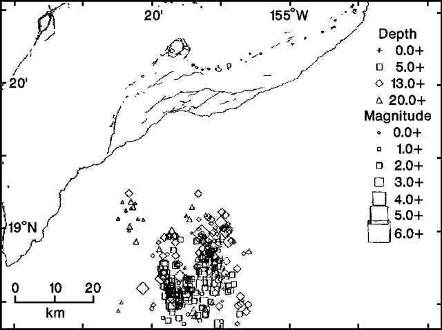 |
Figure 5. Hypocenters of swarm events near Lōʻihi Seamount, 19-23 December 1991. Locations are from the HYPOINVERSE program. Courtesy of HVO. |
A plot of 1986-90 events (figure 6) outlines Lōʻihi's summit. The summit region was surveyed in 1986; an August/September 1991 SeaBeam resurvey from the NOAA ship Discoverer revealed no significant morphologic changes exceeding the 5-15 m resolution of the comparison technique.
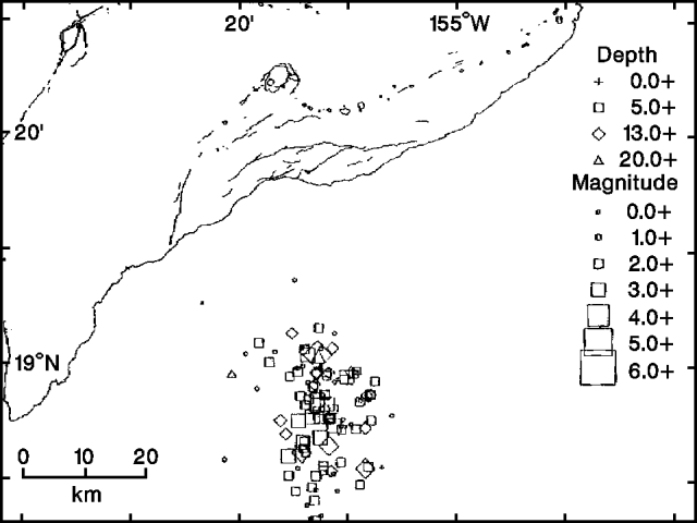 |
Figure 6. Hypocenters of swarm events near Lōʻihi Seamount, 1986-90, located using the HYPOINVERSE program. Courtesy of HVO. |
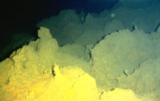
Geological Summary. The Kama’ehuakanaloa seamount, previously known as Loihi, lies about 35 km off the SE coast of the island of Hawaii. This youngest volcano of the Hawaiian chain has an elongated morphology dominated by two curving rift zones extending north and south of the summit. The summit region contains a caldera about 3 x 4 km and exhibits numerous lava cones, the highest of which is about 975 m below the ocean surface. The summit platform also includes two well-defined pit craters, sediment-free glassy lava, and low-temperature hydrothermal venting. An arcuate chain of small cones on the western edge of the summit extends north and south of the pit craters and merges into the crests prominent rift zones. Seismicity indicates a magmatic system distinct from that of Kilauea. During 1996 a new pit crater formed at the summit, and lava flows were erupted. Continued volcanism is expected to eventually build a new island; time estimates for the summit to reach the ocean surface range from roughly 10,000 to 100,000 years.
Information Contacts: P. Okubo, USGS Hawaiian Volcano Observatory; W. Chadwick, Oregon State University; C. Fox, NOAA.