Report on Pacaya (Guatemala) — December 1991

Bulletin of the Global Volcanism Network, vol. 16, no. 12 (December 1991)
Managing Editor: Lindsay McClelland.
Pacaya (Guatemala) Stronger explosions; October lava extrusion continues
Please cite this report as:
Global Volcanism Program, 1991. Report on Pacaya (Guatemala) (McClelland, L., ed.). Bulletin of the Global Volcanism Network, 16:12. Smithsonian Institution. https://doi.org/10.5479/si.GVP.BGVN199112-342110
Pacaya
Guatemala
14.382°N, 90.601°W; summit elev. 2569 m
All times are local (unless otherwise noted)
During 1991, 14 eruptive episodes were documented at Pacaya, with the strongest in July and August (figure 9 and 16:7 & 9). Continuous gas emission, punctuated by occasional explosive activity, characterized the activity until 28 September, when explosions began to eject pyroclastic material to 25-35 m above the main crater. Weak to moderate explosions were more frequent in October. Extrusion of lava onto the SW flank began on 27 October, and this flow remained active as of early January.
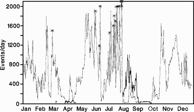 |
Figure 9. Number of seismically recorded explosions (dashed lines) and B-type events (solid lines) at Pacaya, 1991. Stars mark the strongest eruptive episodes. Courtesy of INSIVUMEH. |
Strong explosions on 8 January ejected substantial amounts of pyroclastic material to 200-400 m height. The explosions destroyed part of the active crater, and were accompanied by acoustic waves that were heard and felt over a radius of 15 km. Seismic activity increased for 7 hours on 8 January, with 80-150 recorded explosions/hour accompanied by tremor of constant frequency and higher amplitude. Explosion shocks and tremor declined after the 8 January activity. INSIVUMEH's volcanology section notified the Emergency Committee and recommended that appropriate precautions be taken. Preparations were made to evacuate the 5,000 residents nearest the volcano, but activity declined and none were evacuated. Vigorous explosions resumed on 13 January.
Geological Summary. Eruptions from Pacaya are frequently visible from Guatemala City, the nation's capital. This complex basaltic volcano was constructed just outside the southern topographic rim of the 14 x 16 km Pleistocene Amatitlán caldera. A cluster of dacitic lava domes occupies the southern caldera floor. The post-caldera Pacaya massif includes the older Pacaya Viejo and Cerro Grande stratovolcanoes and the currently active Mackenney stratovolcano. Collapse of Pacaya Viejo between 600 and 1,500 years ago produced a debris-avalanche deposit that extends 25 km onto the Pacific coastal plain and left an arcuate scarp inside which the modern Pacaya volcano (Mackenney cone) grew. The NW-flank Cerro Chino crater was last active in the 19th century. During the past several decades, activity has consisted of frequent Strombolian eruptions with intermittent lava flow extrusion that has partially filled in the caldera moat and covered the flanks of Mackenney cone, punctuated by occasional larger explosive eruptions that partially destroy the summit.
Information Contacts: Sección de Vulcanología, INSIVUMEH; Reuters.