Report on Taal (Philippines) — January 1992
Bulletin of the Global Volcanism Network, vol. 17, no. 1 (January 1992)
Managing Editor: Lindsay McClelland.
Taal (Philippines) Earthquake swarm, deformation, and new fissures document apparent intrusion; evacuations
Please cite this report as:
Global Volcanism Program, 1992. Report on Taal (Philippines) (McClelland, L., ed.). Bulletin of the Global Volcanism Network, 17:1. Smithsonian Institution. https://doi.org/10.5479/si.GVP.BGVN199201-273070
Taal
Philippines
14.0106°N, 120.9975°E; summit elev. 311 m
All times are local (unless otherwise noted)
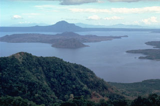
A sudden increase in local seismicity began early 14 February, reaching a peak of 385 high-frequency earthquakes recorded between 1200 on 14 February and 0600 on 15 February. Many were felt in 6 towns near the shores of Lake Taal, which fills the 15 x 22 km caldera. The active cone forms an island near the center of Lake Taal. According to press reports, volcanologists observed that water temperature in the island's crater lake (1.0 x 1.4 km) increased by several degrees, and that a bulge and several fissures (up to 400 m long) had formed on the volcano's N flank. A Notice to Airmen was issued at 1445 on 14 February, advising all aircraft to exercise caution and avoid flying over the area. PHIVOLCS elevated the volcano's status to Alert Level 3 on 15 February and authorities began to evacuate island residents. By the following day, >2,600 of the island's 6,000 residents had reportedly been evacuated. Seismicity quickly decreased on 15 February, and only 14 earthquakes were recorded during a 13-hour period on 16 February. Geologists suggested that the activity represented a magma intrusion episode that appeared to have stopped.
A similar episode of increased seismicity occurred in March-April 1991, with as many as 64 earthquakes (25 March) recorded under the E side of the volcano (16:3). Several thousand people were evacuated from the island. Seismicity decreased in May 1991, and no more than five earthquakes were recorded daily in early August . No inflation was observed.
Geological Summary. Taal is one of the most active volcanoes in the Philippines and has produced some powerful eruptions. The 15 x 20 km Talisay (Taal) caldera is largely filled by Lake Taal, whose 267 km2 surface lies only 3 m above sea level. The maximum depth of the lake is 160 m, with several submerged eruptive centers. The 5-km-wide Volcano Island in north-central Lake Taal is the location of all observed eruptions. The island is composed of coalescing small stratovolcanoes, tuff rings, and scoria cones. Powerful pyroclastic flows and surges have caused many fatalities.
Information Contacts: PHIVOLCS; T. Fox, ICAO; AP; UPI; Reuters.

