Report on Merapi (Indonesia) — February 1992

Bulletin of the Global Volcanism Network, vol. 17, no. 2 (February 1992)
Managing Editor: Lindsay McClelland.
Merapi (Indonesia) Lava dome growth and pyroclastic flows
Please cite this report as:
Global Volcanism Program, 1992. Report on Merapi (Indonesia) (McClelland, L., ed.). Bulletin of the Global Volcanism Network, 17:2. Smithsonian Institution. https://doi.org/10.5479/si.GVP.BGVN199202-263250
Merapi
Indonesia
7.54°S, 110.446°E; summit elev. 2910 m
All times are local (unless otherwise noted)
The following supersedes [16:12 and 17:1].
Increased seismicity preceded the start of summit-area lava extrusion that was first observed on 20 January. Deep (A type, 3.1-3.7 km depth) and shallow (B type,
Glowing rockfalls were first seen on 20 January between 1800 and 2000, emerging from a narrow opening between the NW crater rim (formed by the 1957 lava dome) and the 1984 dome. The rockfalls initially traveled an estimated 125 m from the summit, but they extended farther with time, to ~1,500 m on 31 January (figures 3 and 4). A new lava dome was covering the NW part of the 1984 dome when geologists from the MVO climbed the volcano on 31 January. The 1992 lava was ~50 m higher than the 1984 dome.
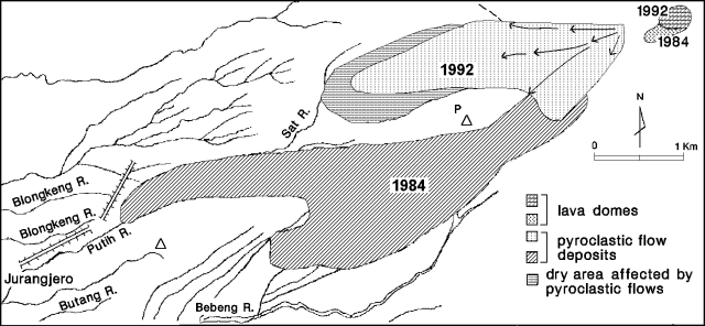 |
Figure 3. Sketch map of Merapi's 1992 lava dome, and the distribution of avalanche-generated, pyroclastic-flow deposits as of 18 February. Courtesy of MVO. |
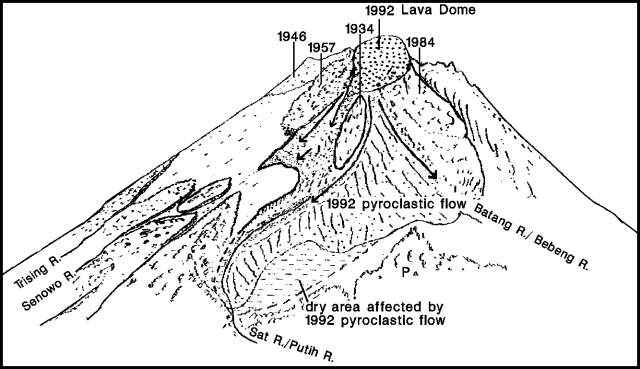 |
Figure 4. View of Merapi at 0630 on 3 March 1992, drawn by Sadjiman from Jurangjero, ~ 8 km WSW of the summit. Courtesy of MVO. |
The first avalanche-generated pyroclastic flow occurred on 31 January at 1535, and three more were detected the next day (table 5).
Table 5. Number of avalanche-generated pyroclastic flows at Merapi, 31 January-2 March 1992. Courtesy of MVO.
| Date | Pyroclastic Flows | Distance from summit (m) |
| 31 Jan 1992 | 1 | 800 |
| 01 Feb 1992 | 3 | 850-900 |
| 02 Feb 1992 | 3 | up to 4000 |
| 04 Feb 1992 | 9 | 800-1500 |
| 05 Feb 1992 | 7 | up to 1500 |
| 06 Feb 1992 | 2 | up to 2000 |
| 07 Feb 1992 | 6 | up to 3500 |
| 10 Feb 1992 | 3 | 1000-1750 |
| 12 Feb 1992 | 1 | 800 |
| 17 Feb 1992 | 20 | 1500-2500 |
| 18 Feb 1992 | 3 | 1500-2000 |
| 20 Feb 1992 | 5 | 600-1000 |
| 21 Feb 1992 | 1 | 1750 |
| 25 Feb 1992 | 1 | 800 |
| 29 Feb 1992 | 1 | 2000 |
| 01 Mar 1992 | 1 | 2000 |
The most vigorous pyroclastic-flow activity was on 2 February, when 33 were observed between 1220 and 2221, extending a maximum of 4 km from the summit. These were accompanied by small explosions that were heard 4 km NW of the summit (at Babadan Observatory). Ash rose to 2,600 m above the summit. Sulfur odors were also noted. Volcanic earthquakes were very rare during the eruption.
Pyroclastic-flow intensity then decreased; none have occurred since 2 March, but the lava dome continued to grow as of mid-March. Glowing rockfalls were nearly continuous (>1,000/day since 2 March), but relatively small, extending
Four alert levels have been established by VSI at Merapi: 1) Notifies residents of increased activity and the need for awareness and caution: 2) More serious precursors require increased awareness; local authorities are requested to prepare for hazard prevention and evacuation: 3) All persons living in the danger zone must pack valuables and items that would supply basic needs during an evacuation: 4) Evacuation required because of explosive eruption and the approach of pyroclastic flows toward inhabited areas.
During the 1992 eruption, Alert Level 1 was announced on 24 January, increasing to Level 2 on 1 February at 2215, and to Level 3 the next day at 1430. As the eruption intensity decreased, the alert level was lowered to 2 on 12 February and to 1 on 2 March.
Geological Summary. Merapi, one of Indonesia's most active volcanoes, lies in one of the world's most densely populated areas and dominates the landscape immediately north of the major city of Yogyakarta. It is the youngest and southernmost of a volcanic chain extending NNW to Ungaran volcano. Growth of Old Merapi during the Pleistocene ended with major edifice collapse perhaps about 2,000 years ago, leaving a large arcuate scarp cutting the eroded older Batulawang volcano. Subsequent growth of the steep-sided Young Merapi edifice, its upper part unvegetated due to frequent activity, began SW of the earlier collapse scarp. Pyroclastic flows and lahars accompanying growth and collapse of the steep-sided active summit lava dome have devastated cultivated lands on the western-to-southern flanks and caused many fatalities.
Information Contacts: S. Bronto, MVO.