Report on Unzendake (Japan) — February 1992

Bulletin of the Global Volcanism Network, vol. 17, no. 2 (February 1992)
Managing Editor: Lindsay McClelland.
Unzendake (Japan) Continued dome growth; occasional pyroclastic flows; large debris flow nearly reaches coast
Please cite this report as:
Global Volcanism Program, 1992. Report on Unzendake (Japan) (McClelland, L., ed.). Bulletin of the Global Volcanism Network, 17:2. Smithsonian Institution. https://doi.org/10.5479/si.GVP.BGVN199202-282100
Unzendake
Japan
32.761°N, 130.299°E; summit elev. 1483 m
All times are local (unless otherwise noted)
Summit lava dome growth continued through early March, with frequent pyroclastic flows generated by partial dome collapse. Geologists estimated that by late January, the volume of the dome complex was 40 x 106 m3, and that ~ 75 x 106 m3 of lava had been extruded since 20 May 1991. The rate of extrusion was around 3 x 10⁵ m3/day during December-January, a rate that has remained nearly constant since June 1991.
Most of the growth of dome 6 . . . had been endogenous in mid-February through early March, then became dominantly exogenous. The area around the dome swelled upwards, and complicated "petal" structures formed on its surface. Continued thickening of dome 6 forced dome 5 . . . to the NE. The surface of dome 5 was very reddish, implying that it was composed of older, oxidized lavas, and was dominantly a cryptodome. Rockfalls from the E and N faces of dome 5 produced reddish block-and-ash flow deposits and left behind numerous small cliffs (figure 39). Dome 5 in turn pushed dome 4 (split into N and S parts), especially its N part, which moved more than 50 m to the E during mid-February-early March. Much of dome 4 was eroded or buried by material from other domes, bringing the talus slope flush with its top. Incandescence and strong gas emissions were observed along cracks and pit craters in and near dome 3. Emission of ash-laden plumes became continuous from Jigoku-ato Crater in early March.
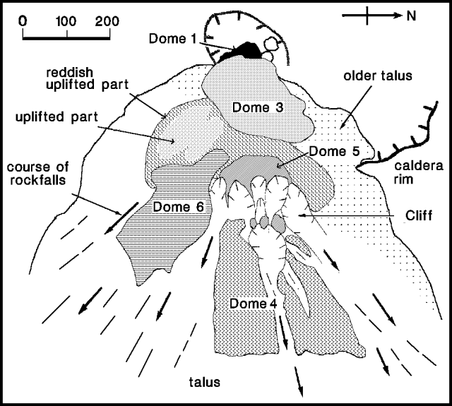 |
Figure 39. Sketch of the lava dome complex at Unzen, 27 February 1992. Courtesy of S. Nakada. |
Lava blocks frequently fell from near the head and front of dome 6, generating pyroclastic flows to the SE and occasionally to the E and NE (figure 40). Clouds of elutriated ash descending to the S sometimes reached the N cliff of Mt. Iwatoko, but the accompanying block-and-ash flows stopped about 300 m short of this point. Thus, trees on the N slope of the cliff were covered by the elutriated ash clouds, but they were neither bent over nor burned. Larger pyroclastic flows occurred on 2 and 12 February. Flows at 2020 and 2028 on 12 February had durations of 290 and 300 seconds, respectively, the longest since 15 September.
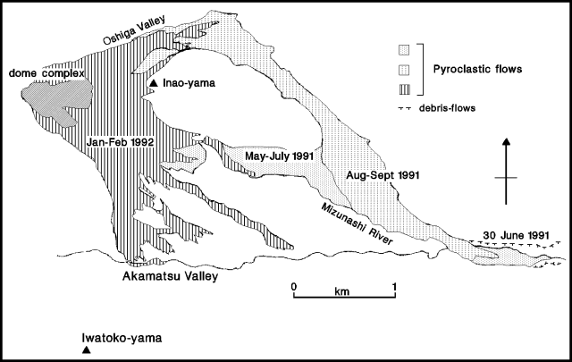 |
Figure 40. Map showing distribution of 1991-92 pyroclastic-flow deposits at Unzen, February 1992. The 1991 pyroclastic-surge deposits are not shown. Courtesy of S. Nakada. |
Heavy rainfall triggered a large debris flow at 0130 on 1 March, along the E flank's Mizunashi River, following the route of the previous large debris flow on 30 June 1991. The flow reached a point 100 m from the coast, 8 km E of the summit, crossing Routes 57 and 251, and burying a 200-m section of the Shimabara Railway. No damage occurred in previously untouched areas, and rail service was resumed within 6 days. As of early March, roughly 7,600 people remained evacuated.
February's 6,434 recorded earthquakes represent the largest monthly total since the eruption began, but seismicity started to decline on 4 March. Seismicity has been at very high levels since October.
Geological Summary. The massive Unzendake volcanic complex comprises much of the Shimabara Peninsula east of the city of Nagasaki. An E-W graben, 30-40 km long, extends across the peninsula. Three large stratovolcanoes with complex structures, Kinugasa on the north, Fugen-dake at the east-center, and Kusenbu on the south, form topographic highs on the broad peninsula. Fugendake and Mayuyama volcanoes in the east-central portion of the andesitic-to-dacitic volcanic complex have been active during the Holocene. The Mayuyama lava dome complex, located along the eastern coast west of Shimabara City, formed about 4000 years ago and was the source of a devastating 1792 CE debris avalanche and tsunami. Historical eruptive activity has been restricted to the summit and flanks of Fugendake. The latest activity during 1990-95 formed a lava dome at the summit, accompanied by pyroclastic flows that caused fatalities and damaged populated areas near Shimabara City.
Information Contacts: S. Nakada, Kyushu Univ; JMA.