Report on Unzendake (Japan) — March 1992

Bulletin of the Global Volcanism Network, vol. 17, no. 3 (March 1992)
Managing Editor: Lindsay McClelland.
Unzendake (Japan) Lava extrusion persists; new dome follows increased seismicity; strong pyroclastic-flow activity
Please cite this report as:
Global Volcanism Program, 1992. Report on Unzendake (Japan) (McClelland, L., ed.). Bulletin of the Global Volcanism Network, 17:3. Smithsonian Institution. https://doi.org/10.5479/si.GVP.BGVN199203-282100
Unzendake
Japan
32.761°N, 130.299°E; summit elev. 1483 m
All times are local (unless otherwise noted)
Lava extrusion . . . was continuing in mid-April 1992. Dome 5 . . . swelled by intrusion, pushing the N half of dome 4 eastward, while dome 6 (formed 3 December 1991) thickened by new surface flows (figure 41). The length of dome 6 did not increase significantly, and the complex "petal" surface structures remained close to the vent, now the highest point in the dome complex. Increased seismicity in early April preceded the extrusion of a new dome (7), which was growing rapidly at mid-month.
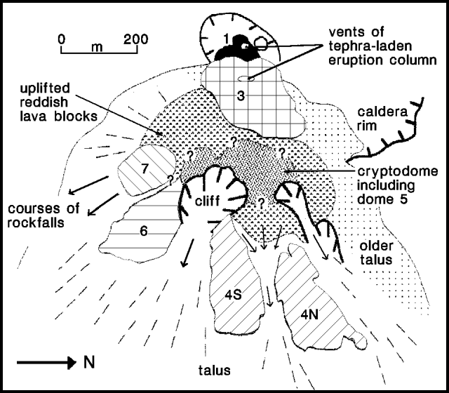 |
Figure 41. Sketch of the dome complex at Unzen, 12 April 1992. Individual domes are numbered. Courtesy of Setsuya Nakada. |
Frequent partial collapse of the front and sides of dome 6, and rarely the E and NE side of dome 5, generated pyroclastic flows that descended SE (toward the Akamatsu River) and sometimes ESE (along the Mizunashi River). During March, 504 pyroclastic flows were seismically recorded, up from 344 in February. The SE slope of the Akamatsu Valley was almost filled by block-and-ash-flow deposits by early April. A large pyroclastic flow, generated by collapse of large blocks between domes 5 and 6 on 1 April, traveled 3 km down the Mizunashi River, reaching the evacuated town of Kita-Kamikoba (where 43 people were killed by the 3 June 1991 flows). The 1 April block-and-ash-flow deposit was thinner, and its ash-cloud surge deposit was thinner and distributed over a much smaller area than those from the 3 June 1991 flows. The 1 April pyroclastic flow was the largest since the 15 September 1991 flows, whose deposit surface and lava blocks continued to steam as of early April. Small pit craters (to 30 cm diameter) were visible on the surface of the September 1991 deposit.
Heavy rainfall triggered three large debris flows in March. The 1 March debris flow reached a point 100 m from the coast (8 km E of the summit) crossing Routes 57 and 251, and burying a 200-m section of the Shimabara Railway. At 1000 on 15 March, 30 mm/hour of rainfall triggered a debris flow of similar size and route. Both highways were crossed, and a 140-m section of the railway was buried by 0.3 m of mud, remaining closed until 14 April. A smaller debris flow occurred along the same route on the morning of 23 March, burying a 30-m section of Route 251. Roughly 7,600 people remained evacuated as of mid-April.
During March, 5,663 earthquakes were recorded on the dome complex, down slightly from 6423 in February. Seismicity declined through mid-March, increased to the highest level of the eruption, and then declined again at the end of the month. The number of earthquakes increased during the first few days of April, before declining once more on 6 April, as a new dome (7) began to emerge. The new dome had grown to 100 x 150 m by 12 April (figure 41).
Geological Summary. The massive Unzendake volcanic complex comprises much of the Shimabara Peninsula east of the city of Nagasaki. An E-W graben, 30-40 km long, extends across the peninsula. Three large stratovolcanoes with complex structures, Kinugasa on the north, Fugen-dake at the east-center, and Kusenbu on the south, form topographic highs on the broad peninsula. Fugendake and Mayuyama volcanoes in the east-central portion of the andesitic-to-dacitic volcanic complex have been active during the Holocene. The Mayuyama lava dome complex, located along the eastern coast west of Shimabara City, formed about 4000 years ago and was the source of a devastating 1792 CE debris avalanche and tsunami. Historical eruptive activity has been restricted to the summit and flanks of Fugendake. The latest activity during 1990-95 formed a lava dome at the summit, accompanied by pyroclastic flows that caused fatalities and damaged populated areas near Shimabara City.
Information Contacts: S. Nakada, Kyushu Univ; JMA.