Report on Yellowstone (United States) — March 1992
Bulletin of the Global Volcanism Network, vol. 17, no. 3 (March 1992)
Managing Editor: Lindsay McClelland.
Yellowstone (United States) Strong new thermal activity
Please cite this report as:
Global Volcanism Program, 1992. Report on Yellowstone (United States) (McClelland, L., ed.). Bulletin of the Global Volcanism Network, 17:3. Smithsonian Institution. https://doi.org/10.5479/si.GVP.BGVN199203-325010
Yellowstone
United States
44.43°N, 110.67°W; summit elev. 2805 m
All times are local (unless otherwise noted)
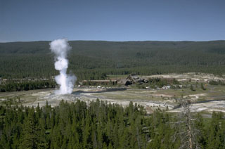
In 1985, a new superheated fumarole formed on the upper E margin of the Mushpots thermal area, which lies on the E side of the caldera associated with the youngest of Yellowstone's three cycles of voluminous rhyolitic volcanism, 0.6 million years ago. The presence of vegetation and the limited extent of bare thermal ground indicated that heat flow near the site of the new fumarole had been moderate to low for at least the previous 15 years. Interviews with park personnel strongly suggested that activity began about 3 July 1985. The steam cloud from the vent may have inspired a false report of smoke from the area, but the vent was not discovered until 5 October 1986, during fieldwork by C. Craig-Hunter and Roderick Hutchinson. At that time, the fumarole's transparent dry-steam jet was directed upslope N35°W at an approximate angle of 21°. A small, reddish-brown, iron-stained cone of hydrothermally altered sand-sized material had grown ~ 0.5 m above the uphill side of the rectangular 1.35 x 1.9-m vent, which dipped at an angle under the lower S rim. Just below the fumarole, on the floor of an old thermal zone, were numerous new or recently enlarged, small, steaming, thermal and mud pot vents, covering an area ~ 10 m in diameter. Sulfate and/or yellow elemental sulfur deposits covered most of the area and nearby slopes to the W, SW, and NW. A second area of new or rejuvenated thermal vents was also discovered in the drainage to the south.
Many trees had been killed in line with the fumarole's directed plume and around the margins of the old thermal zone. Mature trees as much as 87 cm in diameter were snapped off at ground level or uprooted, and tops were broken on other trees 40 m from the rim of the old thermal zone (54 m from the fumarole). A narrow zone of hydrothermally altered white chips of glacial till was found among the toppled trees up to 40 m from the thermal zone rim. These ejecta were 6 cm deep on the rim in 1986.
Geologists returned on 12 February 1987, after a nearby Univ of Utah seismograph . . . detected an isolated episode resembling volcanic tremor. The fumarole's temperature had increased (figure 1) and more elemental sulfur and iron sulfates had been deposited in the old thermal zone, but no other changes were evident. Since then, a biannual survey has been conducted in the area.
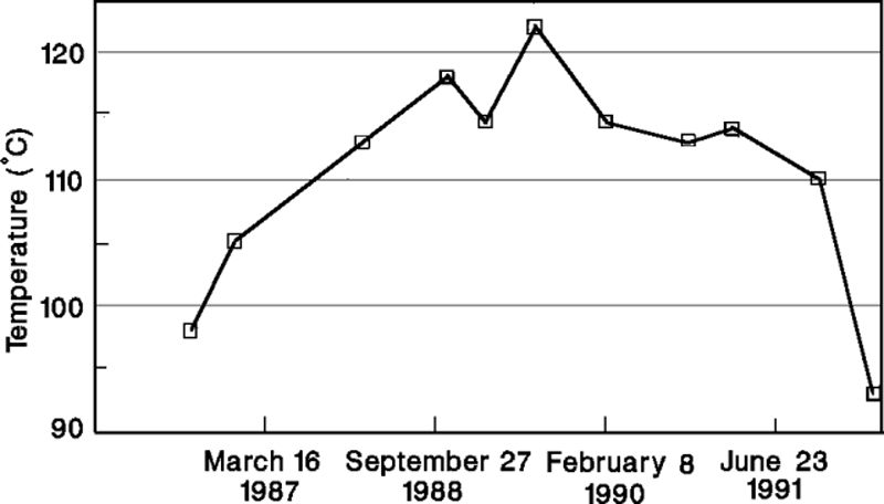 |
Figure 1. Temperatures measured at Mushpot Fumarole, Yellowstone National Park, 5 October 1986-28 March 1992. Courtesy of R. Hutchinson. |
During fieldwork on 28 March 1992, a quiet cloud of wet, 93°C vapor filled the 1985 fumarole's vent. However, less than 30 m downslope (S), on the E margin of the old thermal zone's floor, the ground was shaking violently with the formation and growth of a new mud pot. Bursts of thick, viscous mud were typically doming to 2 m and occasionally to 5 m in diameter before exploding to 3-6 m height. Each explosion shook the ground in all directions. Branches of thermally killed trees shook 50 m away, the ground was visibly moving 8-10 m from the rim, and within 4 m of the rim was behaving like pudding, with violent shaking causing surface oscillations of 1-2 cm. During 90 minutes of observations, the surface area of the mud pot increased by ~ 50%, to an estimated 11 x 7 m. It had a depth of at least 2 m. The minimal amount of ejected mud surrounding the crater and the intense shaking suggested that development of the mud pot had begun within the last 24 hours.
Geological Summary. The Yellowstone Plateau volcanic field developed through three volcanic cycles spanning two million years that included some of the world's largest known eruptions. Eruption of the over 2,450 km3 Huckleberry Ridge Tuff about 2.1 million years ago created the more than 75-km-long Island Park caldera. The second cycle concluded with the eruption of the Mesa Falls Tuff around 1.3 million years ago, forming the 16-km-wide Henrys Fork caldera at the western end of the first caldera. Activity subsequently shifted to the present Yellowstone Plateau and culminated 640,000 years ago with the eruption of the over 1,000 km3 Lava Creek Tuff and the formation of the present 45 x 85 km caldera. Resurgent doming subsequently occurred at both the NE and SW sides of the caldera and voluminous (1000 km3) intracaldera rhyolitic lava flows were erupted between 150,000 and 70,000 years ago. No magmatic eruptions have occurred since the late Pleistocene, but large hydrothermal events took place near Yellowstone Lake during the Holocene. Yellowstone is presently the site of one of the world's largest hydrothermal systems, including Earth's largest concentration of geysers.
Information Contacts: Roderick A. Hutchinson, Yellowstone National Park.