Report on Karangetang (Indonesia) — April 1992
Bulletin of the Global Volcanism Network, vol. 17, no. 4 (April 1992)
Managing Editor: Lindsay McClelland.
Karangetang (Indonesia) Lava extrusion and incandescent tephra emission; pyroclastic flow kills six
Please cite this report as:
Global Volcanism Program, 1992. Report on Karangetang (Indonesia) (McClelland, L., ed.). Bulletin of the Global Volcanism Network, 17:4. Smithsonian Institution. https://doi.org/10.5479/si.GVP.BGVN199204-267020
Karangetang
Indonesia
2.781°N, 125.407°E; summit elev. 1797 m
All times are local (unless otherwise noted)
A pyroclastic flow, triggered by collapse of a lava flow front, killed six people on 11 May.
After an increase in seismicity to as many as 4 events/week in April-May 1991, ash explosions began in the main central crater, ejecting incandescent projectiles to 50-75 m height (16:08). Strombolian activity lasted until August, when lava emission began in the main crater. During September, explosive activity decreased to ash emissions 25-75 m high, accompanied by audible explosions and some incandescence.
Activity increased in February 1992, and incandescent ash emissions became continuous. An estimated 6 x 10⁶ m3 of lava had accumulated in the crater and lava flows began to advance down the S flank's Kali Keting valley. On 2 March, VSI and local authorities warned farmers along the upper Kali Keting to be prepared for the possibility of collapse of the lava flow front and subsequent generation of pyroclastic flows. This region was designated on the 1989 VSI volcano hazard map as being at highest risk of destruction (by pyroclastic flows). At 1330 on 11 May, a pyroclastic flow caused by the collapse of the lava flow front traveled 4 km from the main crater down the Kali Keting, burning seven farmers (six of whom later died in hospitals) and destroying >30 houses and ~2 km2 of coconut, cassava, and nutmeg farms. The pyroclastic-flow deposit had a volume of ~1.2 x 10⁶ m3 (roughly 20% of the lava in the crater). The eruption was continuing as of 19 May, as indicated by the increasing number of volcanic earthquakes and seismically recorded degassing events (table 2).
Table 2. Monthly seismicity at Karangetang, February-19 May 1992. Courtesy of VSI.
| Date | Volcanic A-type | Volcanic B-type | Degassing | Tectonic local | Tectonic distant | Felt shocks |
| Feb 1992 | -- | -- | 12 | 221 | 289 | 4 |
| Mar 1992 | -- | -- | 345 | 101 | 252 | 1 |
| Apr 1992 | -- | -- | 253 | 150 | 158 | 2 |
| 1-19 May 1992 | 21 | 23 | 500 | 13 | 41 | 1 |
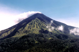
Geological Summary. Karangetang (Api Siau) volcano lies at the northern end of the island of Siau, about 125 km NNE of the NE-most point of Sulawesi. The stratovolcano contains five summit craters along a N-S line. It is one of Indonesia's most active volcanoes, with more than 40 eruptions recorded since 1675 and many additional small eruptions that were not documented (Neumann van Padang, 1951). Twentieth-century eruptions have included frequent explosive activity sometimes accompanied by pyroclastic flows and lahars. Lava dome growth has occurred in the summit craters; collapse of lava flow fronts have produced pyroclastic flows.
Information Contacts: W. Modjo, VSI; UPI.

