Report on Pacaya (Guatemala) — May 1992

Bulletin of the Global Volcanism Network, vol. 17, no. 5 (May 1992)
Managing Editor: Lindsay McClelland.
Pacaya (Guatemala) Numerous explosions; lava flows; temporary evacuations
Please cite this report as:
Global Volcanism Program, 1992. Report on Pacaya (Guatemala) (McClelland, L., ed.). Bulletin of the Global Volcanism Network, 17:5. Smithsonian Institution. https://doi.org/10.5479/si.GVP.BGVN199205-342110
Pacaya
Guatemala
14.382°N, 90.601°W; summit elev. 2569 m
All times are local (unless otherwise noted)
Activity was unusually high through May, with several thousand explosions recorded seismically every day (figure 10). Powerful pyroclastic episodes in early May temporarily forced the evacuations of villages near the W base of the volcano. During the first week of May, two lava flows were extruded from vents near the NW and S summit of MacKenney cone.
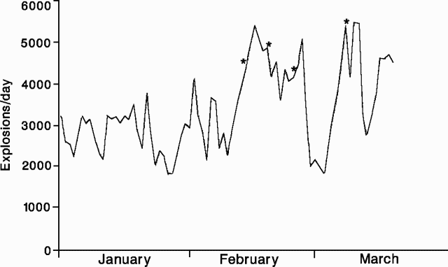 |
Figure 10. Daily number of explosions recorded seismically at Pacaya, January-March 1992. Stars mark the strongest eruptive episodes. Prepared by INSIVUMEH. |
Pacaya has erupted almost continuously since January-February 1990, when Strombolian activity was observed producing a new cone. Strong Strombolian activity destroyed the new cone and lava emission began in July 1990. Since then, lava emission has continued, and periodic increases in explosive activity have resulted in crop damage and the evacuation of up to 1,500 people.
Geological Summary. Eruptions from Pacaya are frequently visible from Guatemala City, the nation's capital. This complex basaltic volcano was constructed just outside the southern topographic rim of the 14 x 16 km Pleistocene Amatitlán caldera. A cluster of dacitic lava domes occupies the southern caldera floor. The post-caldera Pacaya massif includes the older Pacaya Viejo and Cerro Grande stratovolcanoes and the currently active Mackenney stratovolcano. Collapse of Pacaya Viejo between 600 and 1,500 years ago produced a debris-avalanche deposit that extends 25 km onto the Pacific coastal plain and left an arcuate scarp inside which the modern Pacaya volcano (Mackenney cone) grew. The NW-flank Cerro Chino crater was last active in the 19th century. During the past several decades, activity has consisted of frequent Strombolian eruptions with intermittent lava flow extrusion that has partially filled in the caldera moat and covered the flanks of Mackenney cone, punctuated by occasional larger explosive eruptions that partially destroy the summit.
Information Contacts: E. Sanchez and Otoniel Matías, INSIVUMEH, Guatemala City; Michael Conway, Michigan Technological Univ, USA; Rodolfo Morales, INSIVUMEH, Guatemala City.