Report on Rumble III (New Zealand) — June 1992
Bulletin of the Global Volcanism Network, vol. 17, no. 6 (June 1992)
Managing Editor: Lindsay McClelland.
Rumble III (New Zealand) Gas bubbles detected; summit 140 m below surface
Please cite this report as:
Global Volcanism Program, 1992. Report on Rumble III (New Zealand) (McClelland, L., ed.). Bulletin of the Global Volcanism Network, 17:6. Smithsonian Institution. https://doi.org/10.5479/si.GVP.BGVN199206-241130
Rumble III
New Zealand
35.745°S, 178.478°E; summit elev. -220 m
All times are local (unless otherwise noted)
Three previously unknown submarine arc stratovolcanoes have been identified at the S end of the Kermadec Ridge: Rumble V (36.140°S, 178.195°E, summit 700 m below sea level); Tangaroa (36.318°S, 178.031°E, summit 1,350 m below sea level); and Clark (36.423°S, 177.845°E, summit 1,150 m below sea level) (figure 1). All three have basal diameters of 16-18 km and rise from the seafloor at ~2,300 m depth. The first evidence of the volcanoes was from GLORIA side-scan mapping of the southern Havre Trough-Kermadec Ridge region in 1988 (Wright, 1990). Later investigations, including a photographic and rock-dredge study during the 3-week Rapuhia cruise (early 1992), confirmed previous interpretations. Side-scan and photographic data show a complex terrain of lava flows and talus fans on the flanks of all three volcanoes, with the most pristine-looking morphology at Rumble V. During the 1992 cruise, gas bubbles were detected acoustically, rising from the crests of Rumble III, IV, and V. No gas bubbling was evident from Tangaroa or Clark. Bathymetric surveys indicated that the summits of the shallowest volcanoes, Rumble III and IV, were at ~140 and 450 m, respectively, below the sea surface.
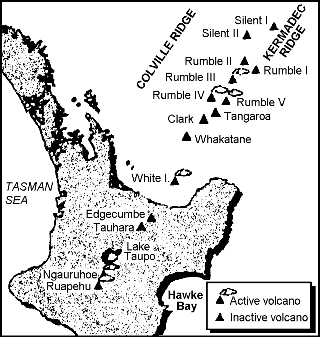 |
Figure 1. Sketch map of New Zealand's North Island and the southern Kermadec Ridge area, with locations of young volcanoes. Courtesy of Ian Wright. |
Reference. Wright, I.C., 1990, Bay of Plenty-Southern Havre Trough physiography, 1:400,000: New Zealand Oceanographic Institute Chart, Miscellaneous Series no. 68.
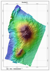
Geological Summary. Rumble III seamount, the largest of the Rumbles group of submarine volcanoes along the South Kermadec Ridge, rises 2,300 m from the seafloor to within about 200 m of the surface. Collapse of the edifice produced a scarp open to the west and a large debris-avalanche deposit. Fresh-looking andesitic rocks have been dredged from the summit and basaltic lava from its flanks. It has been the source of several submarine eruptions detected by hydrophone signals.
Information Contacts: I. Wright, New Zealand Oceanographic Institute, National Institute of Water and Atmospheric Research, Wellington.