Report on Pinatubo (Philippines) — June 1992
Bulletin of the Global Volcanism Network, vol. 17, no. 6 (June 1992)
Managing Editor: Lindsay McClelland.
Pinatubo (Philippines) Lava dome extruded into caldera lake; small steam-and-ash ejections; lahars and secondary explosions
Please cite this report as:
Global Volcanism Program, 1992. Report on Pinatubo (Philippines) (McClelland, L., ed.). Bulletin of the Global Volcanism Network, 17:6. Smithsonian Institution. https://doi.org/10.5479/si.GVP.BGVN199206-273083
Pinatubo
Philippines
15.13°N, 120.35°E; summit elev. 1486 m
All times are local (unless otherwise noted)
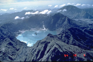
Increased seismicity preceded the emergence of a lava dome into the center of the caldera lake. Moderate steam-and-ash emission was associated with the lava extrusion.
Long-period earthquakes and tremor began to be recorded on 6 July. An aerial survey during the morning of 7 July showed no visible change in steaming from crater vents, although the caldera lake was convecting and somewhat muddier than normal. A small island was reported in the caldera lake early on 9 July. An overflight that day at 1500 revealed a mud cone about 100 m in diameter near the center of the lake, protruding about 5 m above the lake surface. Small phreatic explosions to about 100 m height occurred near the side of the island. PHIVOLCS raised the official alert level to 3, indicating the possibility of an eruption within weeks. The announcement described possible activity as quiet extrusion of a lava dome or moderately explosive phreatomagmatic eruptions. A danger zone of 10-km radius was being enforced.
The cone had reportedly reached 200-300 m in diameter by 12 July. A lava dome 100-150 m in diameter was visible near the center of the island during an aerial survey on 14 July at 0900-1000. The island had grown to around 250-300 m across and was 8-10 m above lake level. A continuous dirty white steam column that included some ash was emerging from the dome and drifting SW during the overflight. Ashfall was reported on two towns ~30 km SW of the summit (San Marcelino and Castillejos) at about 0600 and 1300. The alert level was raised to 5 (eruption in progress).
On the flanks of the volcano, monsoon rains triggered secondary explosions and lahars that forced the evacuation of thousands of people living along rivers. Two people were reported killed by lahars on 12 July. The Department of Social Welfare said that about 70,000 people remained in evacuation centers and resettlement sites in the aftermath of the June 1991 eruption.
Geological Summary. Prior to 1991 Pinatubo volcano was a relatively unknown, heavily forested lava dome complex located 100 km NW of Manila with no records of historical eruptions. The 1991 eruption, one of the world's largest of the 20th century, ejected massive amounts of tephra and produced voluminous pyroclastic flows, forming a small, 2.5-km-wide summit caldera whose floor is now covered by a lake. Caldera formation lowered the height of the summit by more than 300 m. Although the eruption caused hundreds of fatalities and major damage with severe social and economic impact, successful monitoring efforts greatly reduced the number of fatalities. Widespread lahars that redistributed products of the 1991 eruption have continued to cause severe disruption. Previous major eruptive periods, interrupted by lengthy quiescent periods, have produced pyroclastic flows and lahars that were even more extensive than in 1991.
Information Contacts: PHIVOLCS; UPI; Reuters; AP.

