Report on Unzendake (Japan) — June 1992

Bulletin of the Global Volcanism Network, vol. 17, no. 6 (June 1992)
Managing Editor: Lindsay McClelland.
Unzendake (Japan) Continued lava dome growth generates pyroclastic flows
Please cite this report as:
Global Volcanism Program, 1992. Report on Unzendake (Japan) (McClelland, L., ed.). Bulletin of the Global Volcanism Network, 17:6. Smithsonian Institution. https://doi.org/10.5479/si.GVP.BGVN199206-282100
Unzendake
Japan
32.761°N, 130.299°E; summit elev. 1483 m
All times are local (unless otherwise noted)
Growth of the lava dome continued through early July. Partial collapses of the dome complex frequently generated pyroclastic flows. Dome 7, which had begun to emerge in late March, grew exogenously against dome 6 (figure 43), which was buried and eroded by dome 7's lava blocks. Frequent rockfalls from the front and margins of dome 7 reduced its length (to ~ 200 m) and height (to ~ 50 m). Petal or peel structures, which had always appeared on the dome's surface during periods of rapid lava extrusion, were not evident, perhaps indicating a declining magma supply rate. The cryptodome, including dome 5, grew endogenously, frequently generating small rockfalls that were probably triggered by earthquakes within or beneath the dome complex.
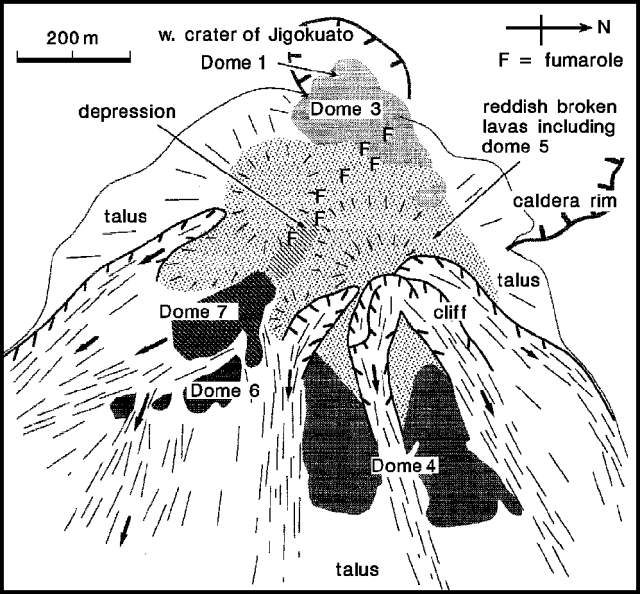 |
Figure 43. Sketch of the dome complex at the summit of Unzen, 8 July 1992. Courtesy of Setsuya Nakada. |
Volcanic gas was emitted continuously from the E part of dome 3, as well as from the depression between domes 3 and 7. The depression divides the cryptodome area into a conical NE section that includes the dome's summit, and a lower SW section with a flat top.
Deposits of the pyroclastic flows that cascade down the SE flank continue to bury the Akamatsu valley. The lowest saddle of the valley's southern cliff remains ~ 10 m high. On 23 June, the ash-cloud surge from a pyroclastic flow struck the saddle, but the main flow did not reach the cliff. The surge toppled brush on the saddle and to ~ 100 m distance, but small cedar trees remained standing. Bark and leaves were not burned, but leaves in the area died. About 10 cm of ash was deposited on the saddle. Thin lead foil, set in a stainless-steel hole to detect the pressure of the ash-cloud surge, was hollowed, and aluminum foil was broken.
Debris flows that have occasionally occurred during the current rainy season eroded pyroclastic flow deposits in the valley. Pyroclastic-flow material was deposited along the valley's N side and in its upper reaches. This deposition pattern, erosion by debris flows, and the declining magma-supply rate delayed the overflow of the lowest part of the saddle by southern-cliff pyroclastic flow deposits. In early July, the Nagasaki prefectural government began to construct a steel fence, 35 m wide and 10 m high, in a stream originating from the saddle, hoping to prevent ash-cloud surges from entering the stream.
JMA reported that the daily number of seismically detected pyroclastic flows ranged from 6 to 21 in June. The total of 373 in June was almost unchanged from previous months. The longest June flow extended 3 km SE from the dome. Most ash clouds generated by the flows rose about 1,000 m, with the highest, to 1,200 m, on 13 and 17 June.
Small earthquakes continued to occur within and beneath the dome complex, at rates of 50-200/day through mid-July. The June total, 3,671 recorded earthquakes, was similar to previous months.
Evacuated areas . . . were somewhat reduced on 11 July, decreasing the number of evacuees from 6,746 to 6,064.
Geological Summary. The massive Unzendake volcanic complex comprises much of the Shimabara Peninsula east of the city of Nagasaki. An E-W graben, 30-40 km long, extends across the peninsula. Three large stratovolcanoes with complex structures, Kinugasa on the north, Fugen-dake at the east-center, and Kusenbu on the south, form topographic highs on the broad peninsula. Fugendake and Mayuyama volcanoes in the east-central portion of the andesitic-to-dacitic volcanic complex have been active during the Holocene. The Mayuyama lava dome complex, located along the eastern coast west of Shimabara City, formed about 4000 years ago and was the source of a devastating 1792 CE debris avalanche and tsunami. Historical eruptive activity has been restricted to the summit and flanks of Fugendake. The latest activity during 1990-95 formed a lava dome at the summit, accompanied by pyroclastic flows that caused fatalities and damaged populated areas near Shimabara City.
Information Contacts: S. Nakada, Kyushu Univ; JMA.