Report on Agrigan (United States) — June 1992
Bulletin of the Global Volcanism Network, vol. 17, no. 6 (June 1992)
Managing Editor: Lindsay McClelland.
Agrigan (United States) Thermal activity but no seismicity or deformation
Please cite this report as:
Global Volcanism Program, 1992. Report on Agrigan (United States) (McClelland, L., ed.). Bulletin of the Global Volcanism Network, 17:6. Smithsonian Institution. https://doi.org/10.5479/si.GVP.BGVN199206-284160
Agrigan
United States
18.77°N, 145.67°E; summit elev. 965 m
All times are local (unless otherwise noted)
A six-member team of USGS volcanologists visited the Commonwealth of the Northern Mariana Islands 11-27 May 1992 at the request of the CNMI Office of Civil Defense. The team observed all of the islands in the chain N of Saipan, installed a new seismic station at the base of frequently active Pagan, remeasured existing EDM networks, mapped the geology of Alamagan, sampled fumaroles and hot springs, and collected rocks and charcoal for radiocarbon dating. No volcanoes in the chain erupted during the observation period.
Remeasurement of five EDM lines on 15-16 May yielded no significant changes (>1 cm) since the network was established in September 1990. Two seismometers temporarily operated on the caldera floor recorded no local shallow seismicity. The temperature of the boiling spring in the caldera was 98°C, the same as in 1990. The volume of water issuing from the hot spring was less than in 1990, maybe because of seasonal rainfall variations. The highest measured fumarole temperature was 102°C, 4° higher than in 1990, perhaps related to a drop in the water table.
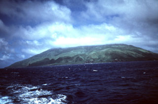
Geological Summary. The highest of the Marianas arc volcanoes, Agrigan contains a 500-m-deep, flat-floored caldera. The elliptical island is 8 km long; its summit is the top of a massive 4000-m-high submarine volcano. Deep radial valleys dissect the flanks of the thickly vegetated stratovolcano. The elongated caldera is 1 x 2 km wide and is breached to the NW, from where a prominent lava flow extends to the coast and forms a lava delta. The caldera floor is surfaced by fresh-looking lava flows and also contains two cones that may have formed during the only historical eruption in 1917. This eruption deposited large blocks and 3 m of ash and lapilli on a village on the SE coast, prompting its evacuation.
Information Contacts: R. Moore, USGS; R. Koyanagi, M. Sako, and F. Trusdell, HVO.