Report on Alamagan (United States) — June 1992
Bulletin of the Global Volcanism Network, vol. 17, no. 6 (June 1992)
Managing Editor: Lindsay McClelland.
Alamagan (United States) Fumarolic activity but no shallow seismicity
Please cite this report as:
Global Volcanism Program, 1992. Report on Alamagan (United States) (McClelland, L., ed.). Bulletin of the Global Volcanism Network, 17:6. Smithsonian Institution. https://doi.org/10.5479/si.GVP.BGVN199206-284180
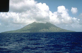
Alamagan
United States
17.6°N, 145.83°E; summit elev. 744 m
All times are local (unless otherwise noted)
A six-member team of USGS volcanologists visited the Commonwealth of the Northern Mariana Islands 11-27 May 1992 at the request of the CNMI Office of Civil Defense. The team observed all of the islands in the chain N of Saipan, installed a new seismic station at the base of frequently active Pagan, remeasured existing EDM networks, mapped the geology of Alamagan, sampled fumaroles and hot springs, and collected rocks and charcoal for radiocarbon dating.
[At Alamagan] the team measured a temperature of 72°C at one fumarole. No shallow earthquakes or volcanic tremor have been recorded on the Alamagan seismic station since it was installed in September 1990. Charcoal was collected that should date the youngest and one of the oldest eruptions.
Geological Summary. Alamagan is the emergent summit of a large stratovolcano in the central Mariana Islands with a roughly 350-m-deep summit crater east of the center of the island. The exposed cone is largely Holocene in age. A 1.6 x 1 km graben cuts the SW flank. An extensive basaltic andesite lava flow has extended the northern coast of the island, and a lava platform also occurs on the S flank. Pyroclastic-flow deposits erupted about 1000 years ago have been dated, but reports of historical eruptions were considered invalid (Moore and Trusdell, 1993).
Information Contacts: R. Moore, USGS; R. Koyanagi, M. Sako, and F. Trusdell, HVO.