Report on Guguan (United States) — June 1992
Bulletin of the Global Volcanism Network, vol. 17, no. 6 (June 1992)
Managing Editor: Lindsay McClelland.
Guguan (United States) No gas emission
Please cite this report as:
Global Volcanism Program, 1992. Report on Guguan (United States) (McClelland, L., ed.). Bulletin of the Global Volcanism Network, 17:6. Smithsonian Institution. https://doi.org/10.5479/si.GVP.BGVN199206-284190
Guguan
United States
17.3137°N, 145.84°E; summit elev. 232 m
All times are local (unless otherwise noted)
A six-member team of USGS volcanologists visited the Commonwealth of the Northern Mariana Islands 11-27 May 1992 at the request of the CNMI Office of Civil Defense. Observations [of Guguan] from an airplane on 13 May and a helicopter on 21 May revealed no gas emission.
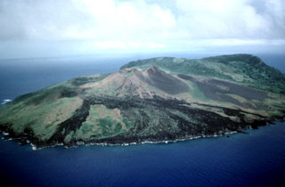
Geological Summary. The island of Guguan, ~2.8 km in diameter, is composed of an eroded volcano on the south, a caldera with a post-caldera cone, and a northern volcano. The latter has three coalescing cones and a breached summit crater that fed lava flows to the W and NW. The only known reported eruption, between 1882 and 1884, produced the northern volcano and lava flows that reached the coast. Freycinet (Uranie 1817 Expedition) confused Guguan and Alamagan; reported eruptions in 1819 and 1901 (Kuno, 1962 CAVW) actually refer to solfataric activity on Alamagan (Corwin, 1971).
Information Contacts: R. Moore, USGS; R. Koyanagi, M. Sako, and F. Trusdell, HVO.