Report on Spurr (United States) — June 1992

Bulletin of the Global Volcanism Network, vol. 17, no. 6 (June 1992)
Managing Editor: Lindsay McClelland.
Spurr (United States) Details of 27 June eruptive cloud
Please cite this report as:
Global Volcanism Program, 1992. Report on Spurr (United States) (McClelland, L., ed.). Bulletin of the Global Volcanism Network, 17:6. Smithsonian Institution. https://doi.org/10.5479/si.GVP.BGVN199206-313040
Spurr
United States
61.299°N, 152.251°W; summit elev. 3374 m
All times are local (unless otherwise noted)
Increased seismicity preceded a brief eruption of Spurr that began on 27 June at 0704, producing an eruption cloud that was carried rapidly NNE. Seismic data suggested that the eruption ended at about 1100, after apparent eruptive pulses at 0814 and 0904. By 1049, shortly before feeding of the plume stopped, data from the Nimbus-7 satellite's TOMS showed its leading edge roughly 500 km from the volcano, near Fairbanks (figure 3), with an apparent SO2 content of 35 kilotons. The next day, the cloud was detached from the volcano but still clearly visible on weather satellite imagery, extending in a 2,000-km arc E and SE over NE Alaska and NW Canada (figures 3 and 4). As the plume elongated, SO2 detected by the TOMS instrument increased to a maximum of 185 kilotons on 28 June at 1125, then decreased slightly to 160 kilotons as it started to dissipate on 29 June. The cloud remained visible on both TOMS data and weather satellite imagery for several more days.
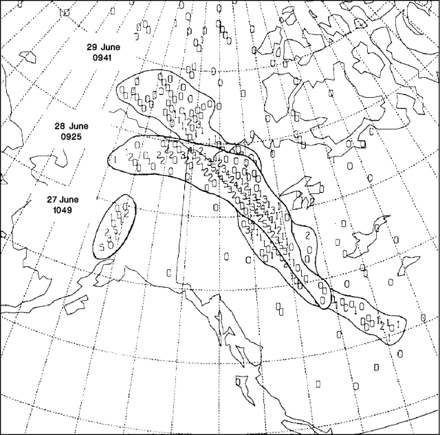 |
Figure 3. Three overlain images of the SO2 cloud from Spurr, as detected by the Total Ozone Mapping Spectrometer on the Nimbus-7 satellite. Values of SO2 in each 50 x 50-km pixel are shown on a relative scale of 0-9, then upward through alphabetic characters with increasing concentration. The cloud slowly dispersed until 3 July, when it could no longer be distinguished above background. Courtesy of Gregg Bluth. |
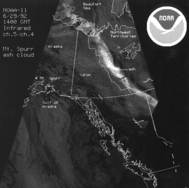 |
Figure 4. Image from the NOAA 11 polar-orbiting weather satellite on 29 June at about 0600, showing the plume from Spurr over the Beaufort Sea and western Canada. Courtesy of NOAA/NESDIS. |
The maximum eruption cloud altitude reported by pilots was about 12 km. However, radar installed on the Kenai Peninsula after the Redoubt eruption, to monitor nearby volcanic activity, measured higher altitudes. At 0803, radar detected a vertical cloud to about 9 km altitude; at 0840, strong returns to 9 km and some material to 14.5 km; at 0950 and 1004, columns to 16 km altitude; and at 1018, to 18 km (figure 5).
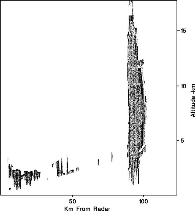 |
Figure 5. One of several radar images of the eruption column from Spurr on 27 June. This image, at 1018, shows echoes from the plume to about 18 km altitude. The instrument, an Enterprise Electronics WSR74C, 5-cm radar, is at Kenai, Alaska, about 80 km away. Vertical scans were used to maximize detection of the vertical cloud; the plume extending downwind is not visible. Courtesy of Joel Curtis and Dale Eubanks. |
Because the plume was carried northward, major air routes to Asia that extend along the Aleutian chain from Anchorage were not affected. A Notice to Airmen warned aircraft to avoid the immediate vicinity of the volcano. No routes were officially closed, but airlines avoided using routes N and NW of the volcano (J501, 111, 133, 120, and 122; and V319, 444, and 480) during the eruption. Flights arriving in Anchorage, 120 km E of Spurr, were routed along normal approaches from the south.
Geological Summary. Mount Spurr is the closest volcano to Anchorage, Alaska (130 km W) and just NE of Chakachamna Lake. The summit is a large lava dome at the center of a roughly 5-km-wide amphitheater open to the south formed by a late-Pleistocene or early Holocene debris avalanche and associated pyroclastic flows that destroyed an older edifice. The debris avalanche traveled more than 25 km SE, and the resulting deposit contains blocks as large as 100 m in diameter. Several ice-carved post-collapse cones or lava domes are present. The youngest vent, Crater Peak, formed at the southern end of the amphitheater and has been the source of about 40 identified Holocene tephra layers. Eruptions from Crater Peak in 1953 and 1992 deposited ash in Anchorage.
Information Contacts: AVO; G. Bluth, NASA GSFC; SAB, NOAA/NESDIS; Joel Curtis and Dale Eubanks, NWS Alaska Region, Anchorage; Darla Gerlach, Air Traffic Division, FAA, Anchorage.