Report on El Chichon (Mexico) — June 1992
Bulletin of the Global Volcanism Network, vol. 17, no. 6 (June 1992)
Managing Editor: Lindsay McClelland.
El Chichon (Mexico) Frequent rockfalls and continued thermal activity
Please cite this report as:
Global Volcanism Program, 1992. Report on El Chichon (Mexico) (McClelland, L., ed.). Bulletin of the Global Volcanism Network, 17:6. Smithsonian Institution. https://doi.org/10.5479/si.GVP.BGVN199206-341120
El Chichon
Mexico
17.3602°N, 93.2297°W; summit elev. 1150 m
All times are local (unless otherwise noted)
The following, from José Luís Macías, Arturo Macías, Jean-Christophe Komorowski, Claus Siebe, and Robert Tilling, describes observations during fieldwork 18 April-21 May 1992, ten years after the major 1982 eruption.
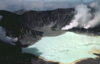
Geology. We made several visits to the crater. The very significant erosion that has occurred in the last 10 years allowed us to descend relatively easily into the crater through its SE wall, where the rim's altitude is 1,060 m. The crater floor is at 900 m elevation.
The only changes that we noticed during our visits were caused by frequent rockfalls from the crater walls. Between the first and second visits, on 19 April and 3 May, new crater-floor rockfall deposits had originated from the SE crater wall. Recently exhumed fault planes veneered by secondary mineralization in the crater wall were also quite common. On the SE part of the rim, a fracture system 90 m long, 6-9 cm wide at its SE end, and 0.2-8 cm wide at the NE end, trended N 65°E, and was associated with mild fumarolic activity. The fracture cuts through bedded domal talus breccia mapped by Rose and others (1984) and might evolve to produce rockfalls in the near future. Several other curviplanar slump fractures encompass apparent areas of several hundred square meters on the crater wall. Thus, more vigorous rockfall activity might be expected, particularly during the coming rainy season or periods of heightened regional seismic activity.
People living near the volcano reported an eruption in late March or early April that produced light ashfall near the volcano, and was accompanied by loud, thunder-like noises. We think that the ashfall most likely was dust produced during large rockfalls from the crater walls, and the noise was the sound of the rockfalls. Eruption-like dust clouds produced by rockfall activity have been described at Kīlauea by Tilling (1974) and Tilling and others (1975).
To try to reduce local alarm, J.L. Macías and J.-C. Komorowski described the current activity and their interpretations of it during an informal conference on 19 May with residents of Chapultenango (11 km ESE of the crater), local authorities, and a group of elementary school teachers. Rumors in El Volcán (5 km E of the crater) that the volcano would erupt on its 10th anniversary caused many women and children to leave their homes.
Crater lake. Temperature and acidity of the crater lake were measured three times at two different sites (table 2). Lake temperature had increased from 28.6°C in 1986 to more than 40° in May 1992, nearing the 42° of October 1983 and February 1984. The pH values of 1.8 and 1.9 measured in 1983 and 1984, respectively, were similar to the April 1992 value. Although no heavy rainfall occurred between 18 April and 8 May, brief rains were common at night and may have diluted the lake with meteoric water, raising its pH. Water samples collected on the lake's N shore are being studied by M.A. Armienta and S. de la Cruz-Reyna at the Instituto de Geofísica, UNAM.
Table 2. Temperature and acidity of the crater lake at El Chichón, measured at sites on the SE and N shores.
| Date | Site | Temperature | pH |
| 18 Apr 1992 | SE shore | 32.4°C | 1.87 |
| 18 Apr 1992 | N shore | 36.9°C | 1.87 |
| 08 May 1992 | SE shore | 32.1°C | 2.15 |
| 08 May 1992 | N shore | 40.1°C | 2.23 |
| 18 May 1992 | SE shore | -- | -- |
| 18 May 1992 | N shore | 40.2°C | 2.31 |
Fumarolic activity. Gas emission from the crater fed a low-altitude plume visible on clear days. Fumarolic activity was observed throughout the crater but was much more extensive and vigorous in its NNE sector (steaming ground zone of Casadevall and others, 1984). Almost all of the fumaroles showed a steady, audible release of overpressured gas, except for one just N of the crater lake, where frequent noise changes showed that output was distinctly discontinuous. At times, vapor formed only within about 1 m above this vent, suggesting that the gas is initially superheated. All of the fumaroles produced sublimates, primarily native sulfur. A high-temperature fumarole NE of the crater lake contains molten orange sulfur within the orifice of a 1-m-high feature otherwise covered with needle-like amorphous yellow sulfur. Numerous mildly steaming areas were found in the NW and NE parts of the crater, and small fumaroles were active several tens of meters above the crater floor along the path descending from the SE crater wall. Relict portions of altered brecciated trachyandesite described by Rose and others (1984) as remnants of the pre-1982 dome and shown on the map of Casadevall and others (1984) as "altered areas" are still actively steaming.
A few fumaroles on the NE side of the crater are characterized by vigorous geyser activity, sending a constant flux of boiling water to 2-3 m height. In the same area, several boiling springs about 2-3 m above the present crater-lake surface produce boiling streams with a significant discharge into the lake, 50 m away. A similar situation was evident near a boiling mud pit in the NW part of the crater. These boiling streams are sites of mineral precipitation, and active red, brown, and green algae growth. Ferns and grasses have returned to some of these hydrothermal areas. Ponds 1 m in diameter on the NW side of the lake contained vigorously boiling mud (rising <1 m) and water.
The crater lake, which had recovered to November 1982 levels by November 1990, was turquoise-blue and had at least two large zones of intense surface effervescence as described by Casadevall and others (1984).
Although an acrid smell was noted at active hydrothermal areas, H2S concentrations must have decreased below the 2-6 ppm that forced geologists to take special precautions in 1983 and to leave the crater in 1984. During several 4-hour periods in the crater, we never needed gas masks, even in the most active areas.
Other observations. In the Río Magdalena near Xochimilco (8 km NW of the crater), vegetation has made a strong comeback on pyroclastic-flow deposits, which are now covered by tall grasses and acacia trees up to 2 m high with trunks several centimeters in diameter. In all other areas within 2-3 km of the crater, the 1982 deposits are covered only by moss, lichen, and tall grass. Where pyroclastic flows and surges did not surmount topographic barriers or deposited only a thin veneer of material, vegetation is much more lush, with trees, ferns, and other broad-leafed tropical plants. Trees that were charred but not totally blown down >5 km away have begun to grow again from their stumps. The river that now passes through El Volcán was formed after the pyroclastic flows changed the former drainage pattern. An abundant, rusty colored precipitate (Fe oxides) was sampled for analysis.
Future work. More extensive field observations within the crater are planned for November or December. We will measure temperature and pH, and sample sites of hydrothermal activity. An attempt will be made to overfly the crater with a COSPEC, to bring portable seismometers into the crater and somma flanks, and to make bathymetric measurements.
References. Casadevall, T., de la Cruz-Reyna, S., Rose, W., Bagley, S., Finnegan, D., and Zoller, W., 1984, Crater lake and post-eruption hydrothermal activity, El Chichón Volcano, México: Journal of Volcanology and Geothermal Research, v. 23, p. 169-191.
Rose, W., Bornhorst, T., Halsor, S., Capaul, W., Plumley, P., de la Cruz-Reyna, S., Mena, M., and Mota, R., 1984, Volcán el Chichón, México: pre-1982 S-rich eruptive activity: Journal of Volcanology and Geothermal Research, v. 23, p. 147-167.
Tilling, R., 1974, Rockfall activity in pit craters, Kīlauea Volcano, Hawaii: Proceedings of the Symposium on "Andean and Antarctic Volcanology Problems", IAVCEI, Santiago, Chile, September 1974, p. 518-528.
Tilling, R., Koyanagi, R., and Holcomb, R., 1975, Rockfall seismicity-correlation with field observations, Makaopuhi Crater, Kīlauea Volcano, Hawaii: Journal of Research, U.S. Geological Survey, v. 3, p. 345-361.
Geological Summary. El Chichón is a small trachyandesitic tuff cone and lava dome complex in an isolated part of the Chiapas region in SE México. Prior to 1982, this relatively unknown volcano was heavily forested and of no greater height than adjacent non-volcanic peaks. The largest dome, the former summit of the volcano, was constructed within a 1.6 x 2 km summit crater created about 220,000 years ago. Two other large craters are located on the SW and SE flanks; a lava dome fills the SW crater, and an older dome is located on the NW flank. More than ten large explosive eruptions have occurred since the mid-Holocene. The powerful 1982 explosive eruptions of high-sulfur, anhydrite-bearing magma destroyed the summit lava dome and were accompanied by pyroclastic flows and surges that devastated an area extending about 8 km around the volcano. The eruptions created a new 1-km-wide, 300-m-deep crater that now contains an acidic crater lake.
Information Contacts: José Luís Macías V. and Michael Sheridan, State Univ of New York, Buffalo, NY; Jean-Christophe Komorowski and Claus Siebe, Instituto de Geofísica, UNAM; Robert Tilling, USGS.