Report on Galeras (Colombia) — June 1992

Bulletin of the Global Volcanism Network, vol. 17, no. 6 (June 1992)
Managing Editor: Lindsay McClelland.
Galeras (Colombia) Strong explosion destroys most of summit lava dome
Please cite this report as:
Global Volcanism Program, 1992. Report on Galeras (Colombia) (McClelland, L., ed.). Bulletin of the Global Volcanism Network, 17:6. Smithsonian Institution. https://doi.org/10.5479/si.GVP.BGVN199206-351080
Galeras
Colombia
1.22°N, 77.37°W; summit elev. 4276 m
All times are local (unless otherwise noted)
An explosion on 16 July, the largest since activity began in 1989, ejected large tephra and may have generated a small pyroclastic flow. Partial collapse of the summit crater's lava dome occurred in June, and minor seismicity had been recorded a few days before the explosion.
June activity. The NW portion of the 1991 lava dome collapsed during June, and explosions and ash emissions occurred from the collapsed area. Las Portillas fumarole, formerly just NW of the dome, was larger after the collapse, and a line of new vents had opened nearby. The fracture on the NW crater wall remained active, and it and Las Portillas appeared to be the highest temperature vents in the crater. Gas columns were generally small, and were dispersed to the N and W. The number and energy release of long-period events (figure 55) and high-frequency earthquakes were low. Ten high-frequency earthquakes occurred in the NW part of the crater, with magnitudes of 0.3-1.7. The amplitude and period of background tremor showed small variations on 15 and 30 June. The maximum rate of SO2 emission measured by COSPEC was ~5,500 t/d.
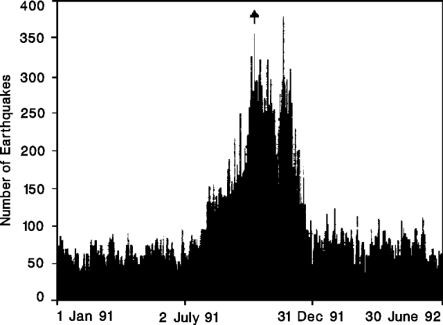 |
Figure 55. Daily number of long-period seismic events at Galeras, 1 January 1991-30 June 1992. The first observation of the summit lava dome is marked by an arrow. Courtesy of INGEOMINAS. |
Precursory seismicity and tilt. Banded tremor episodes of moderate to high energy occurred 11-12 July, accompanied by a small inflationary tilt event recorded on both instruments near the summit. Between 14 and 16 July, six monochromatic long-period events were recorded, with durations on the order of 80 seconds. On 15 July, there was a small swarm of high-frequency events with magnitudes of 0-0.5.
16 July explosion. The explosion began at 1740 with a strong shock felt in Pasto . . . . More than 90% of the summit lava dome was destroyed as at least 120,000 m3 of blocks were ejected, falling primarily on the E and NE flanks. Blocks 30 cm in diameter fell 2.3 km from the crater, and impact craters to 3.5 m across were found 400 m away. Incandescent blocks started fires 2 km from the crater on the NE flank. The tephra severely damaged a small military facility on the crater rim, and dropped 40-cm blocks on telephone and television facilities near the summit. Roughly 30,000 m3 of ash were dispersed in a narrow band to the W, with the 1-mm isopach extending ~10 km. The dark-gray cauliflower-shaped eruption column reached ~4 km altitude. Reports from observers 10 km WSW of the crater (in Consacá) suggested that small pyroclastic flows may have descended the W flank. A powerful sonic wave generated by the explosion broke windows in Pasto, and reportedly in Consacá.
A seismic signal lasting ~8 minutes accompanied the explosion, saturating instruments for the first 37 seconds. Two distinct signals were recognized, one with a frequency of 1 Hz and a duration magnitude of 3, the other a 1.3-Hz tremor episode that lasted 4 minutes. A high-frequency, M 3.2-3.5 event occurred 26 hours after the explosion, in the S part of the volcano at ~5 km depth.
Geological Summary. Galeras, a stratovolcano with a large breached caldera located immediately west of the city of Pasto, is one of Colombia's most frequently active volcanoes. The dominantly andesitic complex has been active for more than 1 million years, and two major caldera collapse eruptions took place during the late Pleistocene. Long-term extensive hydrothermal alteration has contributed to large-scale edifice collapse on at least three occasions, producing debris avalanches that swept to the west and left a large open caldera inside which the modern cone has been constructed. Major explosive eruptions since the mid-Holocene have produced widespread tephra deposits and pyroclastic flows that swept all but the southern flanks. A central cone slightly lower than the caldera rim has been the site of numerous small-to-moderate eruptions since the time of the Spanish conquistadors.
Information Contacts: INGEOMINAS-Observatorio Vulcanológico del Sur.