Report on Lascar (Chile) — June 1992

Bulletin of the Global Volcanism Network, vol. 17, no. 6 (June 1992)
Managing Editor: Lindsay McClelland.
Lascar (Chile) Satellite data show heat from lava dome
Please cite this report as:
Global Volcanism Program, 1992. Report on Lascar (Chile) (McClelland, L., ed.). Bulletin of the Global Volcanism Network, 17:6. Smithsonian Institution. https://doi.org/10.5479/si.GVP.BGVN199206-355100
Lascar
Chile
23.37°S, 67.73°W; summit elev. 5592 m
All times are local (unless otherwise noted)
"A Landsat TM image recorded the night of 15 April 1992 shows the most intense thermal anomaly of a dataset extending back to December 1984. The thermal signature, in the short-wavelength infrared bands 5 (1.55-1.75 mm) and 7 (2.08-2.35 mm), represents the active lava dome in the central crater. Comparison with the previous image (night of 7 January 1991) shows a marked increase in the anomaly's area (figure 11). In the April 1992 scene, the core of the anomaly occupies an irregular area of ~7 x 6 pixels (equivalent to 210 x 180 m). These dimensions correspond closely with the 180-190 m dome diameter estimated from 20 March airphotos (17:5). The increase in area of the TM anomaly may be explained, at least in part, by the growth of a subsidiary lava dome first sighted on 4 March. The summed thermal radiance from the whole hot spot shows a corresponding increase in the April Landsat image (figure 12).
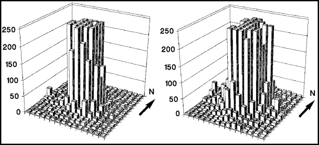 |
Figure 11. 15 x 15 pixel maps (equivalent to 450 x 450 m) of the signal recorded in band 7 of the Landsat TM over Lascar at night on 7 January 1991 (left) and 15 April 1992 (right). The vertical axis represents the number between 0 and 255 proportional to the spectral radiance. In each case, several pixels are saturated. Courtesy of C. Oppenheimer. |
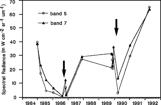 |
Figure 12. Summed spectral radiance in bands 5 and 7 for fifteen images acquired over Lascar since December 1984. The dataset includes several processing formats, and images acquired during the day and night. Only pixels with a thermal signal >=10 were included. The total was then converted to spectral radiance using calibration coefficients supplied with the digital data. Arrows mark the explosive eruptions of September 1986 and February 1990 (12:4-5 and 15:2-3). Courtesy of C. Oppenheimer. |
"An interesting feature of the two most recent TM acquisitions is the persistence of a discrete hot site ~200 m W of the centre of the main anomaly (figure 11). This is very likely the expression of incandescent fumarole vent(s) beyond the steep margin of the extruded lava."
Reference. Oppenheimer, C., Francis, P.W., Rothery, D.A., Carlton, R.W., and Glaze, L.S., Analysis of Volcanic Thermal Features in Infrared Images: Lascar Volcano, Chile, 1984-1992; Journal of Geophysical Research, in press.
Geological Summary. Láscar is the most active volcano of the northern Chilean Andes. The andesitic-to-dacitic stratovolcano contains six overlapping summit craters. Prominent lava flows descend its NW flanks. An older, higher stratovolcano 5 km E, Volcán Aguas Calientes, displays a well-developed summit crater and a probable Holocene lava flow near its summit (de Silva and Francis, 1991). Láscar consists of two major edifices; activity began at the eastern volcano and then shifted to the western cone. The largest eruption took place about 26,500 years ago, and following the eruption of the Tumbres scoria flow about 9000 years ago, activity shifted back to the eastern edifice, where three overlapping craters were formed. Frequent small-to-moderate explosive eruptions have been recorded since the mid-19th century, along with periodic larger eruptions that produced ashfall hundreds of kilometers away. The largest historical eruption took place in 1993, producing pyroclastic flows to 8.5 km NW of the summit and ashfall in Buenos Aires.
Information Contacts: C. Oppenheimer, D. Rothery, P. Francis, and R. Carlton, Open Univ.