Report on Unzendake (Japan) — July 1992

Bulletin of the Global Volcanism Network, vol. 17, no. 7 (July 1992)
Managing Editor: Lindsay McClelland.
Unzendake (Japan) Dome growth slows, but rockfalls and heavy rain trigger destructive pyroclastic and debris flows
Please cite this report as:
Global Volcanism Program, 1992. Report on Unzendake (Japan) (McClelland, L., ed.). Bulletin of the Global Volcanism Network, 17:7. Smithsonian Institution. https://doi.org/10.5479/si.GVP.BGVN199207-282100
Unzendake
Japan
32.761°N, 130.299°E; summit elev. 1483 m
All times are local (unless otherwise noted)
The lava dome complex continued to grow through mid-August (table 9). Viscous lava did not continuously reach the surface, although magmatic intrusion caused some endogenous growth. Changes to the size of the dome complex were small, and the magma-supply rate has decreased to half of its peak of > 300,000 m3/day in late 1991-early 1992. A rough estimate of the late July-early August rate is 110,000-160,000 m3/day. Earthquakes had been frequent during periods of endogenous growth at the higher magma-supply rate, but recently there have been few seismic events in the absence of lava extrusion, implying that magma is no longer being continuously supplied to the dome complex.
Table 9. Chronology of eruptive events at Unzen, July 1990 to mid-August 1992. Courtesy of JMA.
| Date | Volcanic Activity |
| Jul 1990 | Earthquakes and tremor episodes began. |
| 17 Nov 1990 | Phreatic ash eruption. |
| 12 Feb 1991 | Phreatic ash eruption resumed at Byobu-iwa crater. |
| Apr 1991 | Phreatic eruptions at Jigoku-ato crater. |
| 13 May 1991 | Summit seismicity and deformation begin. |
| 20 May 1991 | Lava dome 1 emerged in Jigoku-ato crater. |
| 24 May 1991 | First pyroclastic flow observed. |
| 03 Jun 1991 | Large pyroclastic flow killing 43 people and damaging 179 houses; growth of lava dome 2 began shortly thereafter. |
| 08 Jun 1991 | Large pyroclastic flow, extending 5.5 km and damaging 207 houses. |
| 11 Jun 1991 | Explosion, producing block fall in inhabited areas. |
| 30 Jun 1991 | The largest debris flow, caused by heavy rainfall, damaging 202 houses. |
| 11 Aug 1991 | Summit seismicity began to increase. |
| 12 Aug 1991 | Ejection of incandescent blocks. Continuous ash emission. Sudden decrease in pyroclastic flows. |
| 13 Aug 1991 | Dome 3 recognized, W of dome 2. |
| 25 Aug 1991 | Beginning of pyroclastic flow activity into Oshiga valley. |
| 31 Aug 1991 | Evacuation from Senbongi area, NE of the summit. |
| 06 Sep 1991 | Summit seismicity began to increase. |
| 15 Sep 1991 | The largest pyroclastic flow, extending 5.5 km, damaged 218 houses. |
| 16 Sep 1991 | Peak of summit seismicity. |
| 17 Sep 1991 | Summit seismicity declined. New dome 4 recognized from the air. |
| 24 Oct 1991 | Summit seismicity began to increase. |
| 25 Oct 1991 | Dome inflation recognized from the air. |
| Nov 1991 | Inflation of dome 4. Increase in summit seismicity, and decrease in pyroclastic flow activity. |
| late Nov 1991 | Cryptodome 5 formed. |
| 03 Dec 1991 | Lava dome 6 began to emerge. |
| through Dec 1991 | Continuous growth of dome 6. Pyroclastic flows to SE and ESE (Tansanui and Oshiga valleys). |
| late Dec 1991 | Summit seismicity declined. |
| 27 Dec 1991 | Shimabara Railway traffic resumed. |
| 29 Dec 1991 | Summit seismicity resumed. |
| Jan 1992 | High seismicity at summit. Pyroclastic flows to E and ESE. |
| 02 Feb 1992 | Large pyroclastic flow, extending 3 km; no damage. |
| 12 Feb 1992 | 30-minute pyroclastic flow sequence triggered by partial collapse of dome 6. Many pyroclastic flows to the SE. |
| 22 Apr 1992 | Many pyroclastic flows to the SE. |
| 08 Aug 1992 | Many pyroclastic flows to the SE damage 17 houses; large debris flow damages 72 houses. |
| 12-13 Aug 1992 | Large debris flows destroy 55 houses. |
| 15 Aug 1992 | Debris flow destroys 40 houses. |
Dome 7 (figure 44), which began to emerge in late March, grew exogenously in late July, creating petal and peel structures on its surface. A few days after dome 7 stopped growing, the axis of the petal structures was buried by material that collapsed from the dome above it, and its surface became reddish, implying that magma supply had nearly ceased.
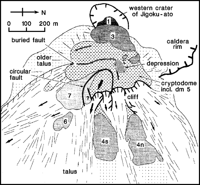 |
Figure 44. Sketch of the dome complex at the summit of Unzen, 7 August 1992. A plug-like lava block surrounded by a circular fault was being slowly pushed eastward, as shown by the arrow on the plug. Arrows on the talus show the directions taken by rockfalls. Volcanic gases were emitted from dome 3 and along the buried fault. Courtesy of Setsuya Nakada. |
In early August, plug-like blocks of the cryptodome, a mass of brown lava surrounded by circular faults, were pushed horizontally eastward at an average rate of ~ 10 m/day. Geologists believe that the plug may represent a magma conduit inclining westward beneath Jigoku-ato crater that was the source of viscous lava when the magma-supply rate was high. A grayish fresh lava surface with step-growth wrinkles appeared along the circular fault.
Rockfalls from the plug and its periphery generated pyroclastic flows along the Mizunashi River (SE of the summit) and Akamatsu Valley (S and SE of the volcano), traveling ~ 3 km from the crater. When a part of the cryptodome collapsed, a reddish ash cloud rose from the rockfalls to ~1,000 m, the highest to 1,300 m on 5 July. Ash frequently fell on inhabited areas around the volcano (including Shimabara city and Fukae town, which extend to within 7 and 4 km of the dome, respectively, and the Unzen spa area).
Small earthquakes continued to occur within and beneath the dome complex, at rates recorded by JMA of 50-400/day in July and the first half of August. Rates in late July were the highest since March, and the July total of 5,614 was also the largest since March.
Seismometers began to record a burst of pyroclastic flows, the most vigorous since 22 April, on 8 August at 0823. Sixteen were recorded by 1030, including events with durations of 180 seconds at 0945, 130 seconds at 0953, and 170 seconds at 1000. Heavy rains and dense clouds from a typhoon, which passed near the volcano that morning, obscured the volcano and prevented determination of pyroclastic-flow lengths and directions. Pyroclastic flows traveling along the Akamatsu Valley ~ 3.5 km from the dome burned 17 houses in an area (Minami-Kamikoba, Fukae town) that had been evacuated since June 1991. An additional house burned on 9 August at about 1330, but the cause of the fire was not known. No houses had been burned by pyroclastic flows since the destruction of 218 on 15 September 1991.
Typhoon rains fell at rates to 60 mm/hour on 8 August, triggering debris flows that produced distinctive signatures on seismic records. Debris flows were frequent along the Mizunashi River on 8 August between 0730 and 0900. The largest extended 7 km E of the dome, burying highways and the Shimabara railway, and damaging 72 houses in Shimabara city and Fukae town. Rain that fell from about noon on 12 August until the next morning caused 2 more large debris flows, at about 1930 on the 12th and 0400 on the 13th. Peak precipitation rates were 30 mm/hour and 10 mm/hour at two nearby rain gauges. The flows again traveled along the Mizunashi river, burying highways and the railway, and destroying 55 houses along both sides of the river's lower reaches. Structural damage from the August debris flows was the first since 30 June 1991. Highways were reopened by the evening of 13 August, but railway traffic was still halted as of 16 August. Forty more houses were destroyed along the Mizunashi River by a rain-induced debris flow early on 15 August. Another typhoon . . . was expected to reach the Unzen area late on 18 August.
Weather prevented observations of changes in dome morphology, as the succession of large pyroclastic flows and debris flows occurred for about a week in mid-August. When geologists examined the debris flows, they were steaming vigorously, and contained hot fragments of lava blocks derived from the youngest pyroclastic flows. A few hours after a debris flow was deposited, surface and interior temperatures of one of its lava blocks were about 80°C and 300°C, respectively. Debris flows were generated in the middle sections of the Oshiga (NE flank) and Akamatsu valleys. The middle portion of the Mizunashi valley was always covered by a sequence of new pyroclastic-flow deposits when visited by geologists.
The evacuated areas . . . were unchanged as of mid-August, and 6,054 residents remained evacuated. None were reported injured by the activity.
Geological Summary. The massive Unzendake volcanic complex comprises much of the Shimabara Peninsula east of the city of Nagasaki. An E-W graben, 30-40 km long, extends across the peninsula. Three large stratovolcanoes with complex structures, Kinugasa on the north, Fugen-dake at the east-center, and Kusenbu on the south, form topographic highs on the broad peninsula. Fugendake and Mayuyama volcanoes in the east-central portion of the andesitic-to-dacitic volcanic complex have been active during the Holocene. The Mayuyama lava dome complex, located along the eastern coast west of Shimabara City, formed about 4000 years ago and was the source of a devastating 1792 CE debris avalanche and tsunami. Historical eruptive activity has been restricted to the summit and flanks of Fugendake. The latest activity during 1990-95 formed a lava dome at the summit, accompanied by pyroclastic flows that caused fatalities and damaged populated areas near Shimabara City.
Information Contacts: S. Nakada, Kyushu Univ; JMA.