Report on Bogoslof (United States) — July 1992

Bulletin of the Global Volcanism Network, vol. 17, no. 7 (July 1992)
Managing Editor: Lindsay McClelland.
Bogoslof (United States) New lava dome enlarges island
Please cite this report as:
Global Volcanism Program, 1992. Report on Bogoslof (United States) (McClelland, L., ed.). Bulletin of the Global Volcanism Network, 17:7. Smithsonian Institution. https://doi.org/10.5479/si.GVP.BGVN199207-311300
Bogoslof
United States
53.93°N, 168.03°W; summit elev. 150 m
All times are local (unless otherwise noted)
A large new lava dome grew on the N side of Bogoslof Island (figure 1) during the steam-and-ash eruption reported in 17:6. The eruption apparently began about 6 July, and the last reports of activity were received on 24 July.
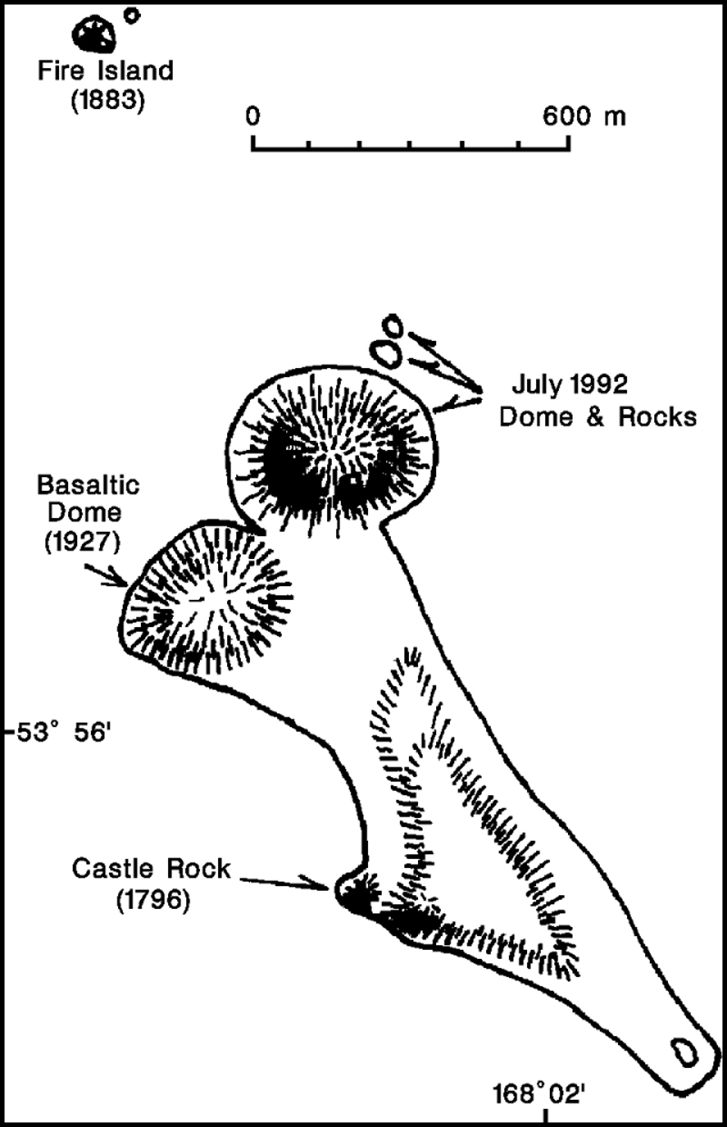 |
Figure 1. Sketch map of Bogoslof Island, showing the 1992 dome and new flat land just offshore (labeled "rocks"). Pre-1992 features are drawn from a 1982 pocket-transit survey by John Reeder, which had shown substantial erosion of the soft 1926-27 pyroclastic deposits since USGS mapping in 1947 (Byers, 1959). Courtesy of John Reeder. |
A plume was first visible on satellite imagery at about 1500 on 6 July, rising to an estimated 3 km altitude. Previous small plumes, if any, would have been obscured by clouds at about 6 km altitude that had remained over the area for the previous few days. Just after 1700 on 6 July, Thomas Madsen (Aleutian Air) saw a continuously rising steam column that disappeared into low clouds at 350 m altitude. From his vantage point 30 km SSE, the column appeared to be emerging from the sea just beyond the island. No eruptive activity had been evident during his previous flight two days earlier. At about 1800, Joe May and David Alborn (MarkAir) saw a white plume reaching at least 1.8 km altitude. During the late afternoon of 7 July, a commercial fisherman saw a rocky new island, with steam and some ash emerging from its summit, between Bogoslof Island and Fire Island (the 1883 dome). A fracture extended from the new island's summit to the sea, from where steam was also rising. No eruptive activity had been evident when the fisherman passed Bogoslof early 6 July.
Only intermittent small plumes appeared on satellite imagery through 13 July. However, plumes were continuous for the next two days, reaching a maximum altitude, on 14 July, of 5.5 km. The largest plume, at 1140 on 15 July, extended ~100 km ESE over neighboring Unalaska Island at 3-3.5 km altitude. At 1755 that day, May and Alborn saw a fairly dark, continuous, steam-and-ash plume that reached about 3.5 km elevation. Satellite images again showed only intermittent plumes 16-17 July, and none since then. Additional pilot observations included a rapidly rising mushroom-shaped cloud with a black stem, reaching at least 4.5 km above sea level on 17 July at 1623 (Wyman Owens, Peninsula Airways). On 20 July at 1830 Joseph Maricelli (Northwest Airlines) saw a gray plume rising from Bogoslof, with a very pale top that may have reached 8 km altitude. A gray cloud was still rising to 4.5 km when Randy Lovett and Tom Peebles (MarkAir) passed at 2056.
Photographs taken from a boat by Larry Shaishnikoff on 21 July, and video footage from a U.S. Coast Guard C-130 aircraft on 24 July, show a profusely steaming new lava dome at the N tip of the main island. Steam with some ash was emerging from most of the dome's surface during Shaishnikoff's visit. Incandescent lava could be seen within large crags over most of the dome, but was brightest on the upper NW and SE flanks. Estimates of its size from the video footage (AVO) and photographs (John Reeder) were similar, at ~80-90 m high and roughly 300-400 m across. It has a steep-sided central spire surrounded by a blocky, more gently sloping debris apron, and is adjacent to the remnant of the 1927 dome. Rock color and surface texture looked very similar to those of the 1927 dome in the Shaishnikoff photos. Approximately horizontal new land ("rocks" on figure 1) extended slightly above sea level just NNE of the dome. No steaming was occurring from these rocks, which may have been uplifted sea floor. Dall porpoises, numerous birds, and some Steller sea lions near Fire Island, several hundred meters from the new dome, did not appear to have been affected by the activity.
Pilot reports of steaming and possible ash emission continued through 24 July, after which occasional pilot observations indicated no further significant activity.
No ashfall has been reported at the two nearest towns, Dutch Harbor/Unalaska (100 km E of Bogoslof) and Nikolski (Umnak I., 120 km SW). The principal hazards from Bogoslof's eruptions are to aircraft in the Aleutian Islands and on Trans-Pacific international routes across the Bering Sea. No aircraft incidents have been reported. A SIGMET issued 20 July was cancelled the next day. No seismometers are maintained near the island.
The volcano's subaerial portion consists of fragmental deposits, agglomerate, lava spires, dome remnants, and beach sediments, all of historical age (Byers, 1959). All sampled rocks are high-potassium andesites and basalts (Arculus et al., 1977). The island is remote and uninhabited, but houses a large sea-lion rookery. The island's low elevation and frequent explosive activity since the first historical eruption in 1796 have resulted in rapid, well-documented morphologic changes over the past 200 years. Particularly vigorous eruptions occurred in 1883, 1907 (both of which deposited small amounts of ash on Dutch Harbor), and 1926-27. These eruptions were characterized by sporadic, violent explosions, with lava flows and dome-building continuing for several months (Jaggar, 1930). Three kilometers of muddy water encountered by a ship near the island in September 1951 may have been from a submarine eruption.
References. Arculus, R., Delong, S., Kay, R.W., Brooks, C., and Sun, S., 1977, The Alkalic Rock Suite of Bogoslof Island, Eastern Aleutian Arc, Alaska: Journal of Geology, v. 85, p. 177-186.
Byers, F.M., 1959, Geology of Umnak and Bogoslof Islands, Alaska: USGS Bulletin 1028-L.
Jaggar, T., 1930, Recent Activity of Bogoslof Volcano: The Volcano Letter, no. 275, p. 1-3.
Geological Summary. Bogoslof is the emergent summit of a submarine volcano that lies 40 km N of the main Aleutian arc. It rises 1,500 m above the Bering Sea floor. Repeated construction and destruction of lava domes at different locations during historical time has greatly modified the appearance of this "Jack-in-the-Box" volcano and has introduced a confusing nomenclature applied during frequent visits by exploring expeditions. The present triangular-shaped, 0.75 x 2 km island consists of remnants of lava domes emplaced from 1796 to 1992. Castle Rock (Old Bogoslof) is a steep-sided pinnacle that is a remnant of a spine from the 1796 eruption. The small Fire Island (New Bogoslof), about 600 m NW of Bogoslof Island, is a remnant of a lava dome formed in 1883.
Information Contacts: AVO; J. Reeder, ADGGS.