Report on Spurr (United States) — July 1992

Bulletin of the Global Volcanism Network, vol. 17, no. 7 (July 1992)
Managing Editor: Lindsay McClelland.
Spurr (United States) Brief but vigorous explosive activity; large cloud causes widespread light ashfall
Please cite this report as:
Global Volcanism Program, 1992. Report on Spurr (United States) (McClelland, L., ed.). Bulletin of the Global Volcanism Network, 17:7. Smithsonian Institution. https://doi.org/10.5479/si.GVP.BGVN199207-313040
Spurr
United States
61.299°N, 152.251°W; summit elev. 3374 m
All times are local (unless otherwise noted)
A brief explosive eruption of Spurr occurred on 18 August, with little or no apparent precursory seismicity. Preliminary data suggested that the 18 August activity was similar to somewhat stronger than the previous explosive episode, on 27 June. The 27 June ash had been carried N, away from nearby populated areas, but the 18 August ash fell on Anchorage, Alaska's largest city, 130 km E of Spurr, closing its international airport and forcing most of its residents indoors.
The eruption was first reported at 1548 by an airplane pilot who saw a dark cloud, probably an ash plume, breaking through weather clouds. About 8 minutes of seismicity at slightly above background preceded the pilot report. No lightning pulses, which often accompany ash eruptions, were detected, but there were additional pilot reports of ash during the next half-hour. Seismicity increased markedly at 1641, and by 1645, NOAA C-band radar had detected a plume to almost 11 km altitude. The National Weather Service released a SIGMET, warning pilots of the ash plume, at 1653.
AVO personnel overflew the volcano about an hour after strong activity began. Dark ash engulfed the entire S portion of the edifice, suggesting that the source of the tephra was in the general vicinity of Crater Peak, the S-flank vent at ~2,300 m elevation that was the source of the 27 June explosive episode. The summit area was clear, but AVO geologists filmed violently roiling, turbulent pulses of black ash ascending through the weather cloud deck at ~2,400 m altitude. Large ballistic fragments were being thrown to 300 m above the cloud deck, and white, lenticular shock-wave clouds ringed the vent area. S of Crater Peak, ash ascended from a light-colored pyroclastic avalanche that had descended to ~900 m elevation (above the Chakachatna river valley). No evidence of flooding was observed, but ash and weather clouds prevented low-altitude flights down the valley. Although lightning apparently was not triggered by the 27 June eruption, 171 lightning strikes were recorded by the AVO detection system in the 1-hour period beginning at 1841 on 18 August. Seismicity began to decline at about 2000, and seismic data suggested that the main phase of the eruption was over at 2020.
The axis of ashfall extended ESE (across Cook Inlet, along Turnagain Arm, and over Prince William Sound) (figure 6). Pilots reported ash to about 18 km altitude, but radar and satellite data suggested that it reached a maximum of about 13.5 km altitude. Ashfall began to diminish at the nearby Beluga Power Plant at 2100. About 0.15-0.3 cm of ash fell on Anchorage between 2000 and 2300; similar amounts were reported from Valdez (300 km E) and Cordova (350 km ESE), where ashfall started at about 0145 and was continuing 4 hours later. Anchorage International Airport was closed at about 2020 and remained closed for much of 19 August, as cleanup efforts were hampered by wind redistribution of the ash. Flights were also halted to and from Elmendorf Air Force Base and Merrill Field (both in the Anchorage area) and Kenai Municipal Airport. A Notice to Airmen announced temporary flight restrictions within 50 km of Spurr, and advised extreme caution downwind of the restricted area. No aircraft encounters with the ash cloud were reported. Health officials warned Anchorage residents, especially those with respiratory problems, to remain indoors during the ashfall.
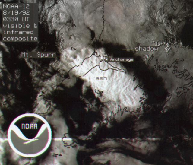 |
Figure 6. Visible/infrared composite image from the NOAA-12 polar-orbiting weather satellite on 18 August at 1930, less than 3 hours after the onset of Spurr's explosive eruption. The ash cloud is illuminated by the sun, and casts a shadow to the NE. Ashfall began at Anchorage about 30 minutes later. Courtesy of G. Stephens. |
Satellite images showed a large plume moving SE at roughly 70 km/hour after feeding from the volcano ended. By the early afternoon of 19 August, ash was observed at 9-10.5 km altitude from an aircraft near Juneau (about 1,000 km ESE of Spurr), and a diffuse ash layer was seen at 2-4.5 km. Very light ashfall was reported at Juneau. By 20 August, the plume had spread over Queen Charlotte Island and coastal British Columbia. Ash was seen at about 10 km altitude from an aircraft near the NW end of Vancouver Island, nearly 2000 km from Spurr. Early on 21 August, satellite imagery showed an arcuate NE-SW plume extending roughly 3500 km from about 55°N in central Saskatchewan across central Alberta, SW British Columbia, and into the Pacific Ocean, to about 38°N, 145°W, off the coast of N California.
Data from the Nimbus-7 satellite's Total Ozone Mapping Spectrometer showed a cloud about 2000 km long, covering an area of 370,000 km2 and containing about 240 kilotons of SO2, on 19 August at 0251 (figure 7). Maximum SO2 values from the 27 June eruption were 185 kilotons (BGVN 17:06).
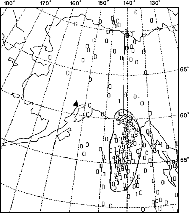 |
Figure 7. Image of the SO2 cloud from Spurr, as detected by the Nimbus-7 satellite's Total Ozone Mapping Spectrometer on 19 August at 0251, about 10 hours after the onset of strong activity. Values of SO2 in each 50 x 50-km pixel are shown on a relative scale of 0-9, then upward through alphabetic characters with increasing concentration. Spurr is marked with a solid triangle. Courtesy of Gregg Bluth. |
A steam plume containing a little ash rose about 2.5 km above the Crater Peak vent during an AVO overflight at 1145 on 19 August, and similar activity was observed by pilots during the afternoon. A swarm of about 12 volcanic earthquakes occurred between 1400 and 1415, and may have been associated with increased steaming. Seismic activity generally decreased slowly, but remained slightly above background during the night. The next day, AVO personnel observed a small steam plume rising less than 500 m above the Crater Peak vent, and minor steaming from the surface of a hot avalanche that had descended the SE flank. Seismicity continued to decline.
Geological Summary. Mount Spurr is the closest volcano to Anchorage, Alaska (130 km W) and just NE of Chakachamna Lake. The summit is a large lava dome at the center of a roughly 5-km-wide amphitheater open to the south formed by a late-Pleistocene or early Holocene debris avalanche and associated pyroclastic flows that destroyed an older edifice. The debris avalanche traveled more than 25 km SE, and the resulting deposit contains blocks as large as 100 m in diameter. Several ice-carved post-collapse cones or lava domes are present. The youngest vent, Crater Peak, formed at the southern end of the amphitheater and has been the source of about 40 identified Holocene tephra layers. Eruptions from Crater Peak in 1953 and 1992 deposited ash in Anchorage.
Information Contacts: AVO; G. Bluth, NASA GSFC; SAB, NOAA/NESDIS; G. Stephens, NOAA/NESDIS; N. Krull, FAA.