Report on Pacaya (Guatemala) — August 1992

Bulletin of the Global Volcanism Network, vol. 17, no. 8 (August 1992)
Managing Editor: Lindsay McClelland.
Pacaya (Guatemala) Stronger explosive activity; lava flows
Please cite this report as:
Global Volcanism Program, 1992. Report on Pacaya (Guatemala) (McClelland, L., ed.). Bulletin of the Global Volcanism Network, 17:8. Smithsonian Institution. https://doi.org/10.5479/si.GVP.BGVN199208-342110
Pacaya
Guatemala
14.382°N, 90.601°W; summit elev. 2569 m
All times are local (unless otherwise noted)
A new cycle of activity has begun since June, with increased energy released by explosions. Continuous degassing from the active (MacKenney) crater produced sustained whitish columns that rose 200-300 m. In July, explosion seismicity increased, with explosions occurring at intervals of 5-30 seconds (figure 11). The strongest were quite energetic, ejecting abundant pyroclastic material that rose 300-400 m above the crater, and generating acoustic waves that were heard and felt in nearby towns. A moderate amount of ash was carried about 5 km W and NW by winds (toward El Patrocinio and El Cedro).
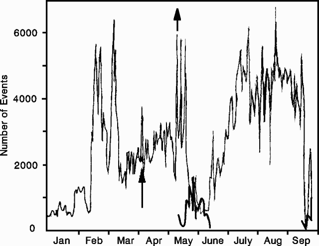 |
Figure 11. Number of explosion events (thin line) and B-type shocks (heavy line) recorded at Pacaya, January-early September 1992. Arrows mark the strongest explosive episodes. Courtesy of INSUVEMEH. |
Activity continued through August. Increased lava extrusion 22-23 August fed a flow that advanced 750 m down the W flank. Two others traveled 75 and 250 m to the SW. Explosions, generally moderate to strong, continued at a rate of 2-5/minute, generating sound waves. The Comité Nacional de Emergencia (CONE) was alerted to the possibility of a stronger eruption.
Activity intensified on 6 September between about 0900 and 1700. Vigorous lava extrusion produced two flows that descended 300 and 1,150 m down the W and SW flanks, respectively, accompanied by moderate Strombolian activity. Explosions from MacKenney Crater ejected abundant ash and fine sand within clouds of white fume that reached about 500 m height. Ash fell on towns about 3.5 km W to SW of the volcano (El Patrocinio, El Rodeo, and El Caracol). Activity then returned to normal levels, about 200-300 explosions per day.
INSIVUMEH officials warned that this pattern of activity could last several weeks and could precede a much stronger eruption. The authorities and people living around the volcano were advised to remain alert to emergency pronouncements issued by CONE. Powerful pyroclastic episodes had forced temporary evacuations of villages near the foot of the volcano in early May (17:05).
Geological Summary. Eruptions from Pacaya are frequently visible from Guatemala City, the nation's capital. This complex basaltic volcano was constructed just outside the southern topographic rim of the 14 x 16 km Pleistocene Amatitlán caldera. A cluster of dacitic lava domes occupies the southern caldera floor. The post-caldera Pacaya massif includes the older Pacaya Viejo and Cerro Grande stratovolcanoes and the currently active Mackenney stratovolcano. Collapse of Pacaya Viejo between 600 and 1,500 years ago produced a debris-avalanche deposit that extends 25 km onto the Pacific coastal plain and left an arcuate scarp inside which the modern Pacaya volcano (Mackenney cone) grew. The NW-flank Cerro Chino crater was last active in the 19th century. During the past several decades, activity has consisted of frequent Strombolian eruptions with intermittent lava flow extrusion that has partially filled in the caldera moat and covered the flanks of Mackenney cone, punctuated by occasional larger explosive eruptions that partially destroy the summit.
Information Contacts: Rodolfo Morales, Gustavo Chigna, and E. Sánchez, INSIVUMEH, Guatemala City.