Report on Eldey (Iceland) — August 1992

Bulletin of the Global Volcanism Network, vol. 17, no. 8 (August 1992)
Managing Editor: Lindsay McClelland.
Eldey (Iceland) Young lava flow identified from submersible
Please cite this report as:
Global Volcanism Program, 1992. Report on Eldey (Iceland) (McClelland, L., ed.). Bulletin of the Global Volcanism Network, 17:8. Smithsonian Institution. https://doi.org/10.5479/si.GVP.BGVN199208-371022
Eldey
Iceland
63.733°N, 23°W; summit elev. 70 m
All times are local (unless otherwise noted)
The following is from a report by Lynn Johnson. "A young lava flow has been identified from deep-diving submersible observations on the northern Reykjanes Ridge at 59.87°N, 29.65°W. A complete lack of sediment cover or biological colonization, minimal alteration, and a distinct boundary between this flow and underlying sediments suggest that this flow is less than 10-20 years old. However, exceptional bottom conditions including unusually strong currents might act to prevent sediment accumulation and biological colonization, allowing this flow to be significantly older (a few hundred to a few thousand years).
"In June, 1992 a 5-member team from the United States joined 10 Russian scientists on Russian Mir deep-diving submersibles to study a possible young lava flow on the Reykjanes Ridge at 59.78°N 29.72°W. The cruise was a cooperative project organized by Kathy Crane (Lamont-Doherty Geological Observatory), Peter Vogt (Naval Research Lab), and Anatoly Sagalavitch (Laboratory of Deep Manned Submersibles, Shirshov Institute of Oceanology, Moscow). The site was chosen because of a microseismic swarm located there by the Worldwide Standardized Seismic Net and an airborne sonobuoy survey in 1989 (Nishimura and others, 1989, and 14:5). In 1990 a SeaMARC II sidescan sonar study showed a highly reflective patch of seafloor within the error radius of the sonobuoy-based epicentral region of the seismic swarm (Shor and others, 1990, and 15:8).
"Our Mir submersible observations reveal that the high backscatter region at 59.78°N is not a young flow, but a flat featureless plain covered with 20-40 cm of sediment. Subsequent dives identified a young flow farther north, but outside of the epicentral region calculated for the 1989 seismic swarm. Four dives in the region between 59.75°N and 59.85°N traversed the ridge axis and several of the ubiquitous small seamounts along the ridge crest (figure 5). Two of these dives also investigated the bounding scarps of the large double ridge segment at that location. Two dives traversed over the northern end of this large segment and the southern end of a smaller segment to the north (59.90°N). With the exception of the one young flow, all of the seafloor observed during over 50 hours of bottom time is comprised of relatively old, sediment-covered and biologically colonized pillow lavas. The young flow was observed and sampled on the flanks of a small seamount at the southern end of the smaller northern axial-ridge segment. Abundant fresh glass is preserved in rocks recovered from this location, and palagonite development is essentially non-existent. The flow lacks sediment cover and biological colonization, and appears to have advanced over an older, sedimented area. Although, except in a few special cases, radiometric dating of mid-ocean ridge basalts (MORB) younger than a few thousand years is not possible, we will try to have the sample dated by recent experimental methods to obtain a more accurate age for recent volcanism at this site.
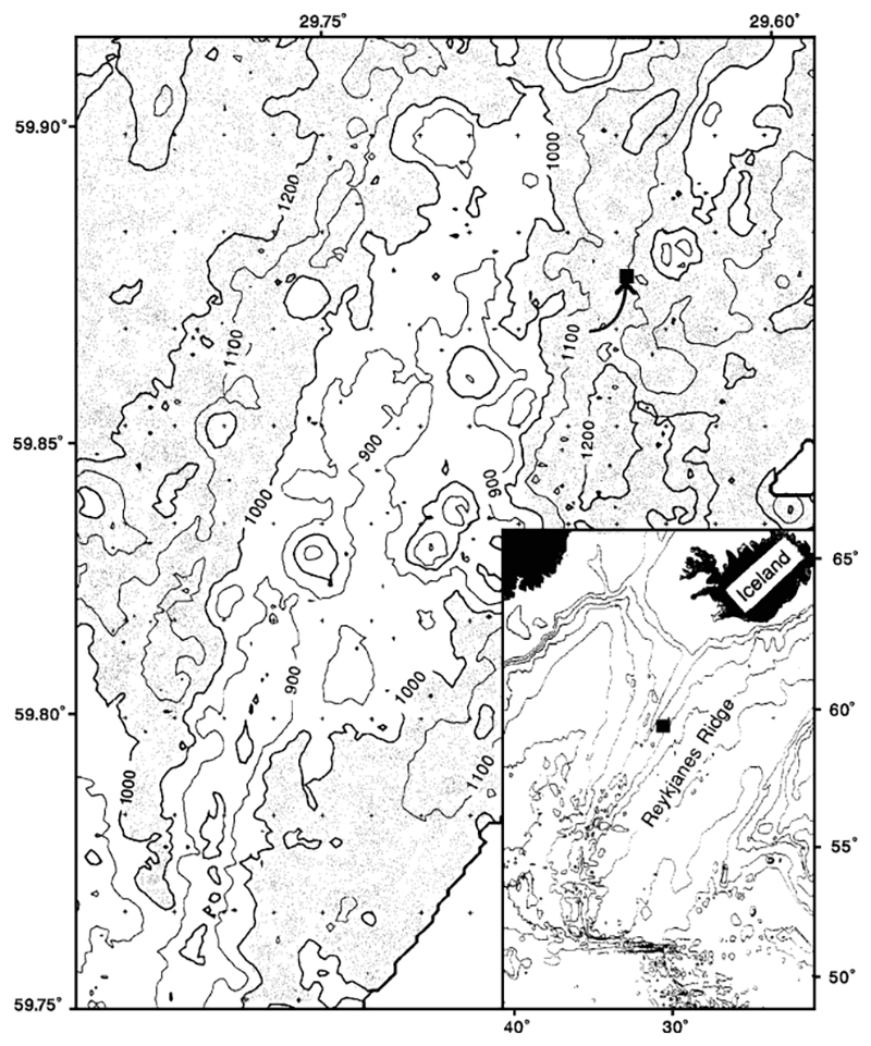 |
Figure 5. Bathymetric map of a segment of the Reykjanes Ridge. Location is shown by a box on the inset map. The arrow marks the site of a young lava flow. Contour interval, 100 m; areas deeper than 1,000 m are shaded. Courtesy of L. Johnson. |
"In addition to video and photographic observations we collected conductivity, temperature, and depth information from one of the submersibles and from the R/V Keldysh, the support ship. No temperature or salinity anomalies indicating hydrothermal activity were recorded. We also collected samples of volcanic rock, water, and sediment using both the submersibles and the surface ship, and conducted a magnetic survey over a 100 km2 area."
References. Nishimura, C.E., Vogt, P.R., Smith, L., and Boyd, J.D., 1989, Investigations of a possible underwater volcanic eruption on the Reykjanes Ridge by airborne sonobuoys and AXBT's: EOS, v. 70, p. 1301.
Shor, A.N., Nishimura, C.E., Czarnecki, M., and Vogt, P.R., 1990, Lava extrusion from the 1989 Reykjanes Ridge seismic swarm? Probably yes (SeaMARC II): EOS, v. 71, p. 1602.
Geological Summary. The Eldey volcanic system is located on the northernmost part of the Reykjanes Ridge and is submarine with the exception of Eldey Island and the skerries (small rocky islands) Eldeyjardrangur, Geirfugladrangur, and Geirfuglasker. Maximum water depth within the system is about 250 m. Characteristic activity consists of explosive submarine basaltic eruptions. Six small eruptions have been located within this system during the last 1,100 years, the last occurring in 1926 CE. Bulletin reports that are included here cover a larger area of the Reykjanes Ridge south of Iceland without a clear source or enough evidence for a separate volcano entry.
Information Contacts: L. Johnson, Naval Research Lab.