Report on Unzendake (Japan) — September 1992

Bulletin of the Global Volcanism Network, vol. 17, no. 9 (September 1992)
Managing Editor: Lindsay McClelland.
Unzendake (Japan) Continued lava-dome growth; collapses generate pyroclastic flows
Please cite this report as:
Global Volcanism Program, 1992. Report on Unzendake (Japan) (McClelland, L., ed.). Bulletin of the Global Volcanism Network, 17:9. Smithsonian Institution. https://doi.org/10.5479/si.GVP.BGVN199209-282100
Unzendake
Japan
32.761°N, 130.299°E; summit elev. 1483 m
All times are local (unless otherwise noted)
The period mid-September to mid-October was characterized by exogenous growth of dome 8 on the SE part of the lava-dome complex. Lava emerged from the SE end of an arc-shaped crack (described as a circular fault in 17:08), piled up near the vent, and repeatedly collapsed from the flow front, ~ 100 m away. This short flow-length implied high-viscosity lava due to a low magma-supply rate, estimated at ~ 105 m3/day from helicopter observations. In 1991, lava domes extended up to 400 m from vents when magma-supply rates exceeded 3 x 10⁵ m3/day. The part of dome 8 that formed along the crack in mid-August and subsequently stopped growing has been uplifted and pushed E.
Rockfalls continued to occur on the E flank (figure 45), increasing the thickness of talus deposits around the dome complex. Domes 7 and 8 generated many pyroclastic flows, mainly toward the SE (Akamatsu Valley), with others to the E (Mizunashi Valley) and NE (Oshiga Valley). Most of the pyroclastic flows traveled 1-2 km, but some extended > 3 km. Ash clouds from the flows rose about 0.5-1 km. Relatively large pyroclastic flows generated by rockfalls from dome 7, which was pushed above dome 6 during the growth of dome 8 in mid-August, occurred at 0918 on 27 September, 1550 on 3 October, and 1944 on 10 October. These pyroclastic flows reached the Kita-Kamikoba and Kami-Onokoba (Fukae town) areas, after traveling 3.4 km along the Mizunashi Valley (3 October) and 3.6 km down the Akamatsu Valley (10 October) from the toe of the dome (~ 400 m from Jigokuato Crater). No damage was done, and the surrounding forest was not burned or destroyed. The rockfall volume that generated these pyroclastic flows was estimated at 0.5-1.0 x 10⁵ m3. Seismic duration of the flow was 160 seconds. Vertical drop during travel was ~ 1 km. The main block-and-ash flows were the longest in 1992 and traveled slightly farther than those of 3 June 1991 . . . .
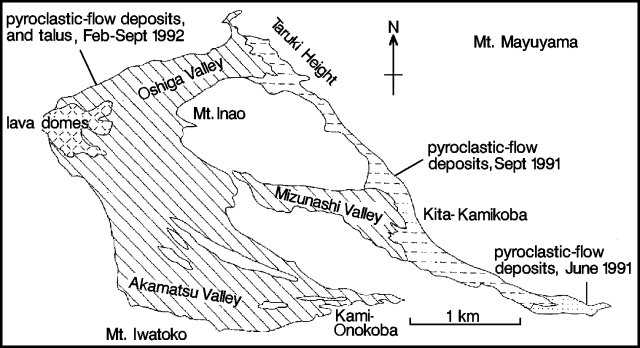 |
Figure 45. Lava dome complex and distribution of pyroclastic-flow deposits at Unzen, mid-September 1992. Deposits from larger pyroclastic flows in late September and early October are not shown. Courtesy of S. Nakada. |
The 27 September pyroclastic flow was videotaped from a helicopter by the Ground Self-Defense Force. The frontal 1/3 of dome 7 (~ 105 m3; 140 m wide, 80 m high, and 20 m deep) suddenly fell away, developing into pyroclastic flows along the divide between the Mizunashi and Akamatsu valleys. The main flow split in two after striking a large block. One portion traveled 3.5 km along the Akamatsu Valley, equaling the 8 August flow (17:08). The videotape showed ash clouds moving steadily (rather than surging) on the ground in the area S and SW of Kami-Onokoba. An inspection from the air 6 hours later showed thick ash covering trees and houses. New damage might be impossible to detect because most of the area had already been destroyed by the 8 August flows and covered with ash.
The frequency of pyroclastic flows detected seismically by JMA ranged from 4 to 36 in September, for a monthly total of 395. Small earthquakes continued both beneath and within the dome complex at rates of 50-600/day and totaled 5,947 for September. Seismicity was most active in mid-September, with 632 events recorded on the 11th. The number of evacuees from Shimbara city and Fukae town was reduced to 3,017 from 6,054 on 9 September. Mayors of the two towns decided on 9 October to leave that number unchanged through the end of the year.
Lava composition has been constant throughout the current activity, which began in May 1991; a 65 wt.% SiO2 dacite with hornblende and biotite phenocrysts. With the exception of volcanic bombs ejected by Vulcanian eruptions on 8 and 11 June 1991, the specific gravity of the lava has remained constant. An ash-laden eruption column was observed on 1 October coming from cracks in dome 3 and filling Jigokuato Crater. The only other ash column observed this year was on 3 April. Volcanic gas activity was strong during this period.
Geological Summary. The massive Unzendake volcanic complex comprises much of the Shimabara Peninsula east of the city of Nagasaki. An E-W graben, 30-40 km long, extends across the peninsula. Three large stratovolcanoes with complex structures, Kinugasa on the north, Fugen-dake at the east-center, and Kusenbu on the south, form topographic highs on the broad peninsula. Fugendake and Mayuyama volcanoes in the east-central portion of the andesitic-to-dacitic volcanic complex have been active during the Holocene. The Mayuyama lava dome complex, located along the eastern coast west of Shimabara City, formed about 4000 years ago and was the source of a devastating 1792 CE debris avalanche and tsunami. Historical eruptive activity has been restricted to the summit and flanks of Fugendake. The latest activity during 1990-95 formed a lava dome at the summit, accompanied by pyroclastic flows that caused fatalities and damaged populated areas near Shimabara City.
Information Contacts: S. Nakada, Kyushu Univ; JMA.