Report on Rincon de la Vieja (Costa Rica) — September 1992
Bulletin of the Global Volcanism Network, vol. 17, no. 9 (September 1992)
Managing Editor: Lindsay McClelland.
Rincon de la Vieja (Costa Rica) Strong fumarolic activity; seismic swarm
Please cite this report as:
Global Volcanism Program, 1992. Report on Rincon de la Vieja (Costa Rica) (McClelland, L., ed.). Bulletin of the Global Volcanism Network, 17:9. Smithsonian Institution. https://doi.org/10.5479/si.GVP.BGVN199209-345020
Rincon de la Vieja
Costa Rica
10.83°N, 85.324°W; summit elev. 1916 m
All times are local (unless otherwise noted)
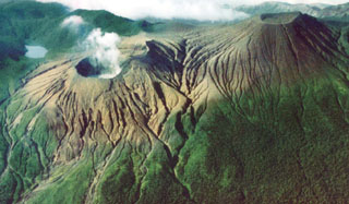
Intense fumarolic activity continued from the SE inner wall of the active crater (figure 5). The emissions were rich in water vapor and sulfurous gases, emerging with a jet-engine sound and rising 350 m above the level of the crater lake in the absence of wind. Sulfur cones formed at the vents. Four main hot areas were evident in the crater lake (near the center, and on the NW, N, and NE sides), which was about 250 m in diameter. The lake was colored gray by the large amount of muddy sediment that it carried in suspension. Strands of mud and sulfur floated on the lake surface. Its temperature was measured by the Instituto Costarricense de Electricidad (ICE) at 52°C on 25 September. Of the 403 events of medium to high frequency recorded in September, 388 occurred between 1 and 10 September, the period in which the medium-frequency seismicity (>2.5 Hz) was recorded (figure 6). Sporadic low-frequency harmonic tremor was detected for periods of up to 2.5 minutes.
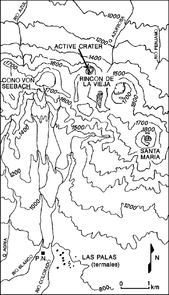 |
Figure 5. Topographic map of the Rincón de la Vieja complex, showing the site of the currently active crater. A national park building near the Las Pailas thermal area on the lower S flank is marked P.N. Contour interval, 200 m below 1,400 m elevation, 100 m at higher altitudes. Courtesy of ICE. |
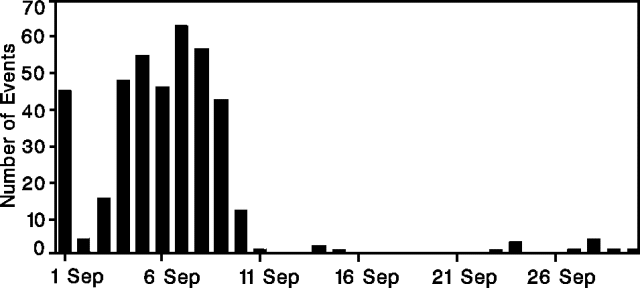 |
Figure 6. Number of seismic events per day at Rincón de la Vieja, recorded by a UNA seismic station (RIN3), 5 km SW of the main crater. Courtesy of UNA. |
Geological Summary. Rincón de la Vieja, the largest volcano in NW Costa Rica, is a remote volcanic complex in the Guanacaste Range. The volcano consists of an elongated, arcuate NW-SE-trending ridge constructed within the 15-km-wide early Pleistocene Guachipelín caldera, whose rim is exposed on the south side. Sometimes known as the "Colossus of Guanacaste," it has an estimated volume of 130 km3 and contains at least nine major eruptive centers. Activity has migrated to the SE, where the youngest-looking craters are located. The twin cone of Santa María volcano, the highest peak of the complex, is located at the eastern end of a smaller, 5-km-wide caldera and has a 500-m-wide crater. A Plinian eruption producing the 0.25 km3 Río Blanca tephra about 3,500 years ago was the last major magmatic eruption. All subsequent eruptions, including numerous historical eruptions possibly dating back to the 16th century, have been from the prominent active crater containing a 500-m-wide acid lake located ENE of Von Seebach crater.
Information Contacts: E. Fernández, J. Barquero, and V. Barboza, OVSICORI; G. Soto and R. Barquero, ICE.