Report on Krakatau (Indonesia) — October 1992

Bulletin of the Global Volcanism Network, vol. 17, no. 10 (October 1992)
Managing Editor: Lindsay McClelland.
Krakatau (Indonesia) Lava flows and incandescent tephra
Please cite this report as:
Global Volcanism Program, 1992. Report on Krakatau (Indonesia) (McClelland, L., ed.). Bulletin of the Global Volcanism Network, 17:10. Smithsonian Institution. https://doi.org/10.5479/si.GVP.BGVN199210-262000
Krakatau
Indonesia
6.1009°S, 105.4233°E; summit elev. 285 m
All times are local (unless otherwise noted)
An eruption that began at 1802 on 7 November ejected lava fragments to 150 m height, followed by an ash explosion to 800 m. Increased seismicity during the first week in November preceded the eruption. A VSI team climbed the volcano on 12 November and reported that the eruption was from Anak Krakatau's NE crater. Lava flows extended 300 m NE and 100 m SE, filling a valley. Approximately 36,000 m2 of the island has been covered by an estimated 178,000 m3 of lava, mostly basaltic andesite with porphyritic to vitrophyric texture. Degassing and ejection of lava fragments was continuing on 12 November at about 3-minute intervals, to heights of 100-200 m. The number of explosion earthquakes decreased from 499 on 11 November to 406 on the 12th, and 296 on the 13th (figure 3). Volcanic tremor with a maximum amplitude of 30.5 mm and a frequency of 0.4 Hz was recorded from 1905 on 12 November until 0800 the next day.
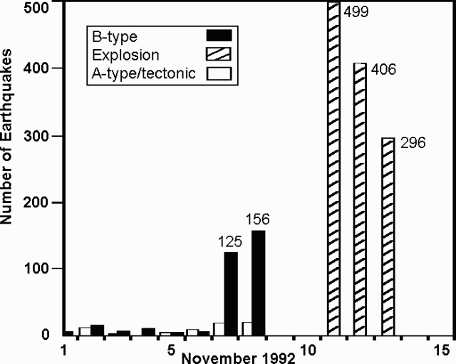 |
Figure 3. Number of earthquakes recorded at Anak Krakatau, 1-13 Nov 1992. Courtesy of VSI. |
Eruptive and seismic activity was continuing on 14 November. Based on the number of explosion earthquakes and the characteristics of volcanic tremor and occasional A-type events, VSI believes that the eruption may continue for several months at the current level of activity. VSI is discouraging visits to the island until further notice.
Geological Summary. The renowned Krakatau (frequently mis-named as Krakatoa) volcano lies in the Sunda Strait between Java and Sumatra. Collapse of an older edifice, perhaps in 416 or 535 CE, formed a 7-km-wide caldera. Remnants of that volcano are preserved in Verlaten and Lang Islands; subsequently the Rakata, Danan, and Perbuwatan cones were formed, coalescing to create the pre-1883 Krakatau Island. Caldera collapse during the catastrophic 1883 eruption destroyed Danan and Perbuwatan, and left only a remnant of Rakata. This eruption caused more than 36,000 fatalities, most as a result of tsunamis that swept the adjacent coastlines of Sumatra and Java. Pyroclastic surges traveled 40 km across the Sunda Strait and reached the Sumatra coast. After a quiescence of less than a half century, the post-collapse cone of Anak Krakatau (Child of Krakatau) was constructed within the 1883 caldera at a point between the former Danan and Perbuwatan cones. Anak Krakatau has been the site of frequent eruptions since 1927.
Information Contacts: W. Modjo, VSI.