Report on Copahue (Chile-Argentina) — October 1992

Bulletin of the Global Volcanism Network, vol. 17, no. 10 (October 1992)
Managing Editor: Lindsay McClelland.
Copahue (Chile-Argentina) Small explosions; earthquakes and tremor; pyroclastic sulfur ejected
Please cite this report as:
Global Volcanism Program, 1992. Report on Copahue (Chile-Argentina) (McClelland, L., ed.). Bulletin of the Global Volcanism Network, 17:10. Smithsonian Institution. https://doi.org/10.5479/si.GVP.BGVN199210-357090
Copahue
Chile-Argentina
37.856°S, 71.183°W; summit elev. 2953 m
All times are local (unless otherwise noted)
Explosive activity at Copahue began on 31 July. Tephra from repeated moderate explosions was generally carried eastward, and mudflows extended several kilometers down streams draining the glaciated summit area. Airfall from the largest explosion, on 2 August, covered ~ 88 km2 and debris flows were generated within the valleys of the Agrio (Argentina) and Lomin (Chile) rivers. Tephra from the 6 August explosion covered ~ 23 km2, from the 31 July explosion ~ 1 km2 (figure 4). [All times are Chile local time.]
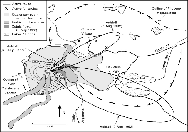 |
Figure 4. Preliminary geologic map of Copahue, showing outlines of Pliocene and Pleistocene calderas, post-caldera lava flows, faults, and fumaroles (not including the one in Del Agrio crater). Distribution of airfall tephra from the 3 main 1992 explosions is also shown. Contour interval, 100 m. Courtesy of A. Bermúdez and D. Delpino. |
Eruptive activity and seismicity, 15 August-20 October. Fumarolic activity was continuous through mid-October, occasionally accompanied by rhythmic explosions. Roaring noise typically preceded the rise of a vapor cloud by some minutes. Fumarolic activity and explosions originated from the same area in the S part of the crater lake. The entire lake was obscured by an intense vapor cloud on some days. The level of water in the lake remains unchanged. Successive explosions have melted the ice on the crater walls, leaving them completely ice-free (unusual at this time of year), and covered the walls with ejecta. Experienced mountaineers often climbed to the crater, reporting an intense sulfur smell and rapid development of eye irritation (perhaps from hydrochloric acid vapor).
The following is from the Grupo de Estudios Vulcanológicos, Proyecto Riesgo Volcánico de Neuquen.
Emission of the light-gray gas cloud reported 15 August was accompanied by increasing harmonic tremor activity (~ 40 episodes/hour) and three high-frequency shocks. Between 18 and 21 August, 80 long-period events were recorded, some of which coincided with phreatic and phreatomagmatic explosions. Material from some of the explosions remained inside Del Agrio crater, but on 19 August, mushroom-shaped columns ~20 and 50 m high were seen. At 1700, a phreatomagmatic explosion from Del Agrio crater fed a gray column ~100 m high. The column rapidly drifted SE, covering the flank with a dark-gray airfall deposit. A heavy snowstorm obscured the volcano 20-23 August, but when weather cleared on the 23rd, dark gray material was visible on the flank. Tremor episodes became increasingly frequent (~ 80/hour) 24-26 August, and nine new long-period events coincided with explosions that ejected dark-gray material. Event durations ranged to 2 minutes 10 seconds. Tremor was harmonic with some high-frequency activity, particularly on 25 August, when high-frequency tremor alternated with harmonic episodes at rates of ~100/hour. Fumarolic activity from Del Agrio crater was accompanied by a light-gray gas cloud on 24 August. Three high-frequency shocks and two long-period events were recorded on 27 August, as intense fumarolic activity formed a dense cloud that covered the crater and appeared to flow toward the E.
A strong increase in tremor episodes (to around 200/hour) characterized the period 28 August-3 September. Ten small high-frequency shocks were recorded 28-30 August. The largest, on 29 August at 1117, had an amplitude of 34 mm and a duration of 35 seconds. It was felt in Caviahue (15 km SE of the volcano) and was accompanied by an explosion sound. Intense fumarolic activity occurred inside the crater 1-2 September. Dense, white, mushroom-shaped clouds sometimes formed within the crater, and others rose 50 m above the summit. Some were light-gray, suggesting the presence of gases other than water vapor. On 3 September, two high-frequency shocks were detected, with a maximum amplitude of 21 mm. Intense tremor activity continued 4-9 September, including some high-frequency episodes.
Tremor decreased somewhat and became banded 10-17 September, with bands of less-frequent episodes (40-50/hour) of low amplitude alternating with those of more-frequent (100-150/hour) stronger tremor. Four small high-frequency shocks were recorded on 16 September (maximum amplitude, 17 mm) but no long-period events were detected. Tremor decreased in amplitude and duration 17-24 September, but was present on all seismograms. Some tremor was banded, and other episodes alternated with quiet periods. Three high-frequency events were recorded on 23 Spetember, one of which (at 0247) was felt at MM II in Caviahue. Four long-period events were registered during the period, but cloud cover and persistent snowfall prevented visual observations. The number of tremor episodes diminished drastically 25 September-11 October. Two patterns were evident, one with isolated periods of tremor on otherwise quiet records, the other (less common) in which weak harmonic tremor covered the seismogram, followed by quiet intervals of 2-5 minutes, then high-frequency tremor. A long-period event lasting 3 minutes on 1 October accompanied an explosion that ejected material. Tremor increased slightly 12-20 October, and five small high-frequency shocks were recorded.
Preliminary information from the Copahue geothermal field, 4 km NNE of Del Agrio crater, indicates no substantial changes. Snow continues to prevent road access to the geothermal field.
Petrology. Samples obtained from debris flows are composed of: lithics; rounded fragments of argillaceous white material; black, shiny fragments of uncertain composition; and small, globular to ribbon-shaped greenish particles. Proportions and size distributions of each component are still being determined. X-ray diffraction shows that the greenish particles are composed entirely of sulfur. Morphology and grain size resemble scoriae, with vesiculated surfaces and interiors. Some show elongation and separation into branches with ball-like terminations. Others are tiny spheres, sometimes deformed and flattened, or Pele's tears. Geologists proposed an eruptive mechanism producing pyroclastic sulfur scoriae similar to those at Poás (Bennett and Raccichini (1978) and Francis and others (1980).
Monitoring. An MEQ-800 seismograph owned by INPRES (Argentina's National Institute of Seismic Warning) and operated by residents of Caviahue municipality is positioned 7.5 km ESE of the active E (Del Agrio) crater. Seismic data and visual observations are telephoned daily to volcanologists Adriana Bermúdez and Daniel Delpino. After 1 September, Delpino left his monitoring post in Caviahue, but he and Bermúdez visit the volcano when activity warrants. Seismograms are sent once a week for reading by the volcanologists, and monthly to INPRES for final interpretation. The provincial government has established the Technical Group for Volcanological Studies to work on the Volcanic Risk Project of Neuquen Province, covering all active volcanoes in the province. A program of volcanological monitoring, detailed mapping, and preparation of a risk map for Copahue has the support of the provincial government. The limited seismic and volcanological monitoring have not revealed a consistent pattern of eruptive behavior at Copahue. For example, no relationship is apparent between increases in fumarolic and tremor activity, or between explosions and high-frequency shocks.
References. Bennett, F.D., and Raccichini, S.M., 1978, Subaqueous sulphur lake in Volcán Poás: Nature, v. 271, p. 342-344.
Francis, P., Thorpe, R., and Brown, G., 1980, Pyroclastic sulphur eruption at Poás volcano, Costa Rica: Nature, v. 283, p. 754-756.
Geological Summary. Volcán Copahue is an elongated composite cone constructed along the Chile-Argentina border within the 6.5 x 8.5 km wide Trapa-Trapa caldera that formed between 0.6 and 0.4 million years ago near the NW margin of the 20 x 15 km Pliocene Caviahue (Del Agrio) caldera. The eastern summit crater, part of a 2-km-long, ENE-WSW line of nine craters, contains a briny, acidic 300-m-wide crater lake (also referred to as El Agrio or Del Agrio) and displays intense fumarolic activity. Acidic hot springs occur below the eastern outlet of the crater lake, contributing to the acidity of the Río Agrio, and another geothermal zone is located within Caviahue caldera about 7 km NE of the summit. Infrequent mild-to-moderate explosive eruptions have been recorded since the 18th century. Twentieth-century eruptions from the crater lake have ejected pyroclastic rocks and chilled liquid sulfur fragments.
Information Contacts: D. Delpino and A. Bermúdez, Dirección Provincial de Minería, Neuquen, Argentina.