Report on Unzendake (Japan) — November 1992

Bulletin of the Global Volcanism Network, vol. 17, no. 11 (November 1992)
Managing Editor: Lindsay McClelland.
Unzendake (Japan) Continued dome growth spawns more pyroclastic flows
Please cite this report as:
Global Volcanism Program, 1992. Report on Unzendake (Japan) (McClelland, L., ed.). Bulletin of the Global Volcanism Network, 17:11. Smithsonian Institution. https://doi.org/10.5479/si.GVP.BGVN199211-282100
Unzendake
Japan
32.761°N, 130.299°E; summit elev. 1483 m
All times are local (unless otherwise noted)
Lava extrusion continued to build dome 8 through mid-November. A depression 150 m across had developed in the center of the lava-dome complex by late October, with dome 8 at the SE edge. Dome growth was dominantly endogenous from mid-November through early December, as older blocks of lava were uplifted into mounds at the NNE and S edges of the depression. The S mound grew eastward and was divided by a NE-trending graben in which a new lava dome (dome 9) appeared on 3 December (figure 46). By 9 December, the dome had grown to ~ 200 m long, 100 m wide, and 30 m high. The light-gray lava from this vent was viscous, blocky, and developed a crude "peel structure" at the vent site. The SE mound near dome 9 continued to grow eastward as of mid-December, implying both endogenous and exogenous growth.
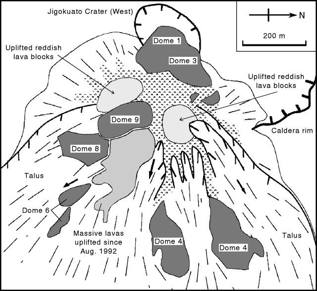 |
Figure 46. Sketch map of the lava dome complex on 9 December 1992. Note that N is to the right. Courtesy of S. Nakada. |
Relatively small-scale pyroclastic flows from dome 8 traveled 1-2.5 km SE into the Akamatsu Valley in mid-November. Ash clouds from the flows rose 0.5-1 km. Small pyroclastic flows to the E and NE generated by the collapse of older lava blocks from the NNE mound sometimes overflowed from the middle of the Oshiga Valley into a northern valley. Rockfalls decreased in frequency during the period of endogenous growth from late November to early December, but resumed on the E sides of the mounds a few days after dome 9 appeared. The frequency of seismically detected pyroclastic flows declined on 13 November and remained at a low level (a few events/day) for more than a month. There were 255 recorded pyroclastic flows in November . . . .
Based on digital mapping by the Geographical Survey Institute, the volume of the lava dome complex is estimated at 47 x 106 m3, with 120 x 106 m3 of magma erupted since 20 May 1991. The volume of the complex is almost the same as in August, implying that the volume of collapsed lava blocks approximately equaled new magma production during this period. The average magma-supply rate from early August to mid-November was ~ 1.3 x 10⁶ m3/day. Field observations suggest that the rate was as much as 2.5 x 10⁶ m3/day in mid-August and declined to < 0.5 x 10⁶ m3/day by late November. The rate increased to ~ 1 x 10⁶ m3/day after extrusion of dome 9 in early December.
Gas emission decreased in November, but gases remained at a temperature of ~ 800°C, based on direct measurement by SEVO. Ash-laden eruption columns were observed in mid-November for the first time since early October. Small earthquakes beneath and within the dome complex continued to occur at rates of 100-400/day. A total of 4,865 earthquakes occurred in November, a significant increase from the 2,948 recorded in October. Seismicity continued at a similar rate through mid-December. The number of evacuees . . . has remained unchanged since being reduced to 3,017 on 9 September.
Geological Summary. The massive Unzendake volcanic complex comprises much of the Shimabara Peninsula east of the city of Nagasaki. An E-W graben, 30-40 km long, extends across the peninsula. Three large stratovolcanoes with complex structures, Kinugasa on the north, Fugen-dake at the east-center, and Kusenbu on the south, form topographic highs on the broad peninsula. Fugendake and Mayuyama volcanoes in the east-central portion of the andesitic-to-dacitic volcanic complex have been active during the Holocene. The Mayuyama lava dome complex, located along the eastern coast west of Shimabara City, formed about 4000 years ago and was the source of a devastating 1792 CE debris avalanche and tsunami. Historical eruptive activity has been restricted to the summit and flanks of Fugendake. The latest activity during 1990-95 formed a lava dome at the summit, accompanied by pyroclastic flows that caused fatalities and damaged populated areas near Shimabara City.
Information Contacts: S. Nakada, Kyushu Univ; JMA.