Report on Whakaari/White Island (New Zealand) — December 1992
Bulletin of the Global Volcanism Network, vol. 17, no. 12 (December 1992)
Managing Editor: Lindsay McClelland.
Whakaari/White Island (New Zealand) Eruptive activity declines; rapid deflation
Please cite this report as:
Global Volcanism Program, 1992. Report on Whakaari/White Island (New Zealand) (McClelland, L., ed.). Bulletin of the Global Volcanism Network, 17:12. Smithsonian Institution. https://doi.org/10.5479/si.GVP.BGVN199212-241040
Whakaari/White Island
New Zealand
37.52°S, 177.18°E; summit elev. 294 m
All times are local (unless otherwise noted)
No significant eruptive activity has occurred since June 1992, although a minor ash emission was observed on 25 November. Observations are based on crater visits of 30 October, 19 November, and 8 December.
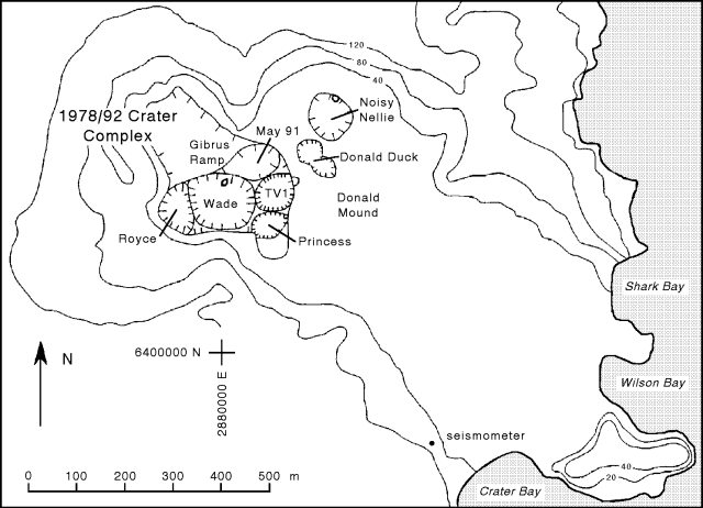
Within the 1978/92 Crater Complex, the three sub-craters observed on 2 September remained on 30 October (figure 18). The divide between May 91 and Wade Craters had collapsed, but two strong fumaroles were re-established through the collapse debris, creating a new "hot wall" in a horseshoe-shaped area on the N side of the former divide. The lake in the center of Wade Crater appeared to be deeper and slightly larger. A fumarole-vent in the western Wade subcrater (named Royce) had enlarged and was emitting white steam. A large SE-trending cavern was observed ~40-50 m below the rim of Princess Crater.
 |
Figure 18. Sketch map of the main crater area of White Island showing crater and peg locations as of 5 May 1993. Crater locations unchanged since September 1992. Courtesy of the IGNS. |
No changes were noted during the 19 November visit, but views were often obscured by strong steam emissions. A small crater lake remained in Wade Crater. Fumarolic activity on the main crater floor was weak, and there was no new ash.
Heavy rains in early December caused landsliding and sedimentation in the Crater Complex. Large landslides from various points around the steep crater wall were heard during fieldwork on 8 December. No new ash or other ejecta was recognized on the crater floor. Royce Crater, now mostly infilled, contained a small pond that was overflowing into the larger lake in Wade Crater. Extensive slumping along the N wall of Wade Crater had partially covered the crater floor. The most intense thermal feature on the island was a large new open vent in the slump deposits that was emitting colorless gas at high pressure. Little change was evident in the other craters.
A levelling survey completed on 8 December revealed that very rapid subsidence (maximum 130 mm), centered near the NE rim of the 1978/92 Crater Complex, had occurred since 13 May. Previous surveys indicate that major subsidence began about one year ago, but the rate has increased in the past 7 months. The deformation has been interpreted as a long-term pattern of steady deflation centered E of the 1978/92 Crater Complex (near Donald Mound). Based on chemical evidence, this deflation is believed to be associated with withdrawal of underlying brine fluids and reduced heat flow. The extremely rapid recent deflation is thought to reflect subterranean collapse.
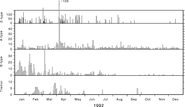
Seismicity has remained consistently low since the last report, on 2 September, with 0-14 A-type events/day, very few B-type, and five E-type (explosion) events (figure 19). Short bursts of low-amplitude tremor were recorded, mostly in late September and early October. Low-frequency tremor was recorded for 12 hours on 22-23 November, just before helicopter pilot R. Fleming reported ash emission from Royce Crater.
Geological Summary. The uninhabited Whakaari/White Island is the 2 x 2.4 km emergent summit of a 16 x 18 km submarine volcano in the Bay of Plenty about 50 km offshore of North Island. The island consists of two overlapping andesitic-to-dacitic stratovolcanoes. The SE side of the crater is open at sea level, with the recent activity centered about 1 km from the shore close to the rear crater wall. Volckner Rocks, sea stacks that are remnants of a lava dome, lie 5 km NW. Descriptions of volcanism since 1826 have included intermittent moderate phreatic, phreatomagmatic, and Strombolian eruptions; activity there also forms a prominent part of Maori legends. The formation of many new vents during the 19th and 20th centuries caused rapid changes in crater floor topography. Collapse of the crater wall in 1914 produced a debris avalanche that buried buildings and workers at a sulfur-mining project. Explosive activity in December 2019 took place while tourists were present, resulting in many fatalities. The official government name Whakaari/White Island is a combination of the full Maori name of Te Puia o Whakaari ("The Dramatic Volcano") and White Island (referencing the constant steam plume) given by Captain James Cook in 1769.
Information Contacts: I. Nairn and B. Scott, IGNS Rotorua.


