Report on Ruapehu (New Zealand) — December 1992

Bulletin of the Global Volcanism Network, vol. 17, no. 12 (December 1992)
Managing Editor: Lindsay McClelland.
Ruapehu (New Zealand) Lake temperature increases; seismic swarm
Please cite this report as:
Global Volcanism Program, 1992. Report on Ruapehu (New Zealand) (McClelland, L., ed.). Bulletin of the Global Volcanism Network, 17:12. Smithsonian Institution. https://doi.org/10.5479/si.GVP.BGVN199212-241100
Ruapehu
New Zealand
39.28°S, 175.57°E; summit elev. 2797 m
All times are local (unless otherwise noted)
Fieldwork on 21 December revealed no evidence of eruptions since the last summit visit on 29 October. Suspended sediment carried by convection colored the crater lake battleship-gray, a change from the clear blue-green color observed in August and September. Evidence for upwelling centers was obscured by wind-generated waves. Pilot observations indicated that the color change began in late November, although the lake was reported to be blue-green on 17 December. Lake temperature was 28.2°C, an increase of 16°C since late October and 18°C since 13 September (figure 14). Snow almost to the waters' edge indicated a lack of recent eruptive surges.
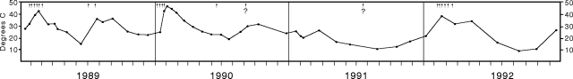 |
Figure 14. Temperature and minor eruptive activity (arrows) at Ruapehu's crater lake, 1989-92. Courtesy of IGNS. |
Seismicity recorded at the nearby Dome shelter station 5-23 November consisted of a sequence of high-frequency shocks followed by strong 2-Hz tremor that gradually declined to background levels over 5-10 days. Tremor was replaced by small discrete volcanic earthquakes, the largest, M 2.0, on 9 November. The signal from the Dome station was lost 23 November-7 December, but occasional volcanic earthquakes were recorded by the more distant Chateau seismograph. When recording from Dome resumed on 7 December, activity was at background levels. No significant deformation was detected during a survey limited by snow conditions.
Based on the seismicity and past activity patterns, geologists believe that the current heating phase began around mid-November, and that small eruptive events are possible in the near future.
Geological Summary. Ruapehu, one of New Zealand's most active volcanoes, is a complex stratovolcano constructed during at least four cone-building episodes dating back to about 200,000 years ago. The dominantly andesitic 110 km3 volcanic massif is elongated in a NNE-SSW direction and surrounded by another 100 km3 ring plain of volcaniclastic debris, including the NW-flank Murimoto debris-avalanche deposit. A series of subplinian eruptions took place between about 22,600 and 10,000 years ago, but pyroclastic flows have been infrequent. The broad summait area and flank contain at least six vents active during the Holocene. Frequent mild-to-moderate explosive eruptions have been recorded from the Te Wai a-Moe (Crater Lake) vent, and tephra characteristics suggest that the crater lake may have formed as recently as 3,000 years ago. Lahars resulting from phreatic eruptions at the summit crater lake are a hazard to a ski area on the upper flanks and lower river valleys.
Information Contacts: P. Otway, IGNS Wairakei; I. Nairn, IGNS Rotorua.