Report on Mayon (Philippines) — January 1993
Bulletin of the Global Volcanism Network, vol. 18, no. 1 (January 1993)
Managing Editor: Lindsay McClelland.
Mayon (Philippines) Explosion generates pyroclastic flow that kills 68 people; activity continuing
Please cite this report as:
Global Volcanism Program, 1993. Report on Mayon (Philippines) (McClelland, L., ed.). Bulletin of the Global Volcanism Network, 18:1. Smithsonian Institution. https://doi.org/10.5479/si.GVP.BGVN199301-273030
Mayon
Philippines
13.257°N, 123.685°E; summit elev. 2462 m
All times are local (unless otherwise noted)
An explosion at 1311 on 2 February generated a pyroclastic flow that traveled 6 km SSE down the Bonga gully and spread out over most of the fan built by 1984 pyroclastic flows. A cauliflower-shaped cloud rose 4.5 km above the summit, and ash fell near Camalig, about 9 km SW. A seismograph 4 km N of the summit recorded the explosion earthquake, which lasted for 6 minutes and 40 seconds, and corresponded with a booming sound. The eruption lasted for about 30 minutes.
Prior to the 2 February eruption, PHIVOLCS conducted visual observations, and seismic monitoring from three permanent stations around the volcano: Mayon Rest House Observatory (MRHO), on the N slope 4 km from the summit; Sta. Misericordia Observatory (SMO), in Sto. Domingo on the E slope 7 km from the summit; and the Lignon Hill Observatory (LHO), in Legaspi City on the SE slope 12 km from the summit. Ground deformation measurements were done at MRHO using a water-tube tiltmeter, a precise leveling line on the N slopes, and two electronic distance meter lines on the N and E slopes. White steam emission varied from wispy to moderate through 1992 and into 1993, with no increase or discoloration prior to the explosion. Seismicity over the same period was usually low, with 0-10 events/day, again with no significant increase before the 2 February event. No inflation or crater glow was observed. PHIVOLCS has since installed six additional seismic stations, with three telemetered seismic stations planned. Teams were also deployed to make ground deformation measurements.
A part of the SE crater rim and/or a block of the wall of the Bonga gully slumped into the gully 1900-1930 on 2 February. There were a few small ash emissions on 3 February. A degassed plug of lava was also growing in the crater, causing incandescent rocks to tumble into Bonga gully. There were two small explosions on 6 February at 0400 and 1600. The one at 0400 produced a small pyroclastic flow. A NOTAM advising all pilots to avoid flying over the area was issued on 4 February. Eruptions larger than the initial explosion occurred on 12 February at 1127 and 1230. The first eruption produced an ash cloud that rose about 1.5 km, and a pyroclastic flow 4 km down the Bonga gully. The second sent an ash cloud to 3 km height and a pyroclastic flow 5 km down the Matanag gully, also on the SE flank of the volcano.
COSPEC measurements from a helicopter detected 1,415 metric tons/day (t/d) SO2 on 3 February. Additional measurements 6, 7, and 8 February were 700, 800, and 900 t/d, respectively.
Press sources have reported at least 68 dead and over 100 injured, almost all resulting from the 2 February pyroclastic flow. No casualties were reported from the 12 February eruptions. An evacuation order has been issued for the area within 6 km of the summit, already off-limits for settlement. Most of the dead were farmers tending crops within the 6 km danger zone. A zone within 10 km on the SE side of the volcano has also been evacuated. The evacuated population was about 60,000 on 17 February.
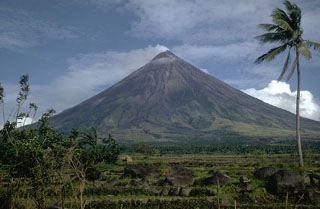
Geological Summary. Symmetrical Mayon, which rises above the Albay Gulf NW of Legazpi City, is the most active volcano of the Philippines. The steep upper slopes are capped by a small summit crater. Recorded eruptions since 1616 CE range from Strombolian to basaltic Plinian, with cyclical activity beginning with basaltic eruptions, followed by longer periods of andesitic lava flows. Eruptions occur predominately from the central conduit and have also produced lava flows that travel far down the flanks. Pyroclastic density currents and mudflows have commonly swept down many of the approximately 40 ravines that radiate from the summit and have often damaged populated lowland areas. A violent eruption in 1814 killed more than 1,200 people and devastated several towns.
Information Contacts: PHIVOLCS; AP.

